Central square
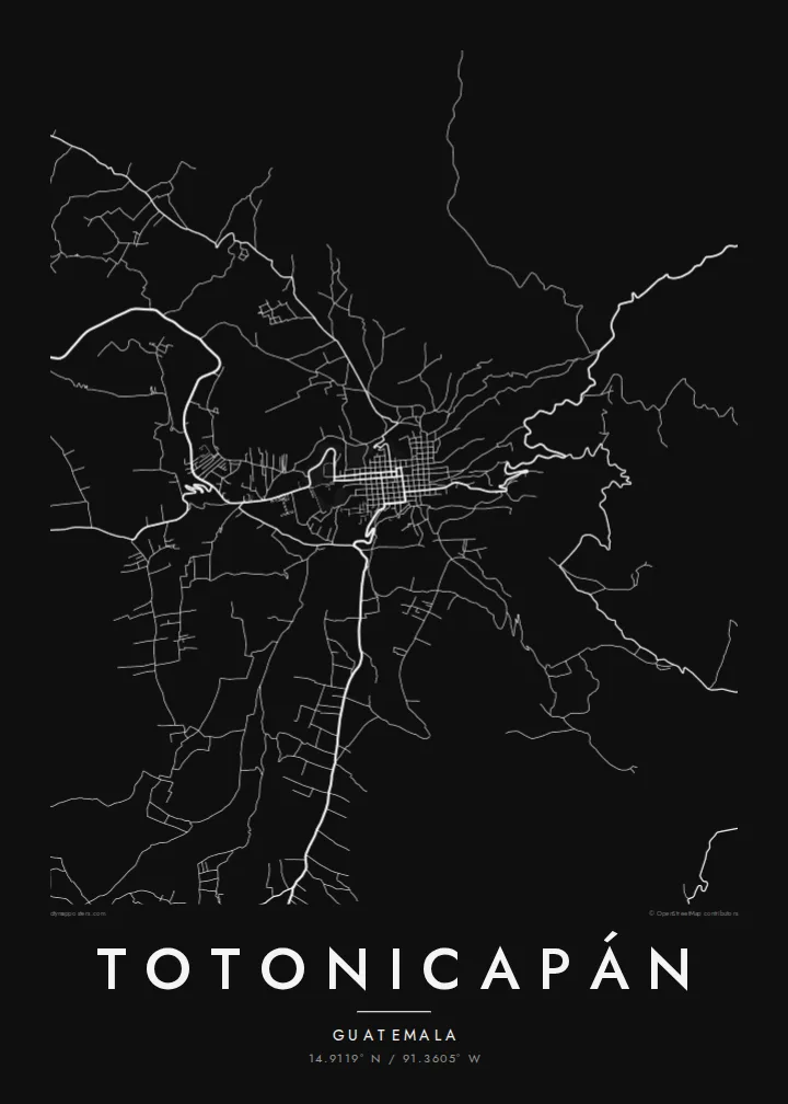
The main plaza anchors the older part of town, with a tight block pattern around it that forms the densest cluster of lines on the poster.
Minimalist map poster · Guatemala
14.9119° N / 91.3605° W
A highland town climbing the sides of a narrow valley, its streets bending with the slopes of the western Guatemalan mountains.



One city, five moods
Ekamowa emwit style ouga bwe ouga ekamowa e dedaña ñan bwega. Style otata a kor eangan — eprint, eframe ke HD files.
 Pixel ekwan · 24 × 36″ print file
Print-sharp
Enin 100% crop eo mai print file eo elango. Poster otata — eprint, eframe ke edownload — erender iaan server bwir e 300 DPI, dedaña ñan 7,200 × 10,800 pixels, bwe lane ekekedik ekwan ebwe crisp iaan print 24 × 36″.
Ituro


The map
Totonicapán lies high in the western highlands of Guatemala, at roughly 2,500 metres, and is the capital of the department of the same name. The town fills a valley floor and spreads up the surrounding slopes. Its map therefore combines a compact centre around the main square with streets that twist and switch back where the ground rises.
Most of the population is K'iche' Maya. Totonicapán is known for a strong tradition of communal self-government through the 48 Cantones, and for crafts such as weaving, pottery and carved wooden masks. The pine forests on the hills above town have long been managed by local communities. On the map they frame the settlement as open space around a dense core.
A Totonicapán map poster captures a town shaped more by terrain than by planning. Around the centre the streets are close and regular. Further out they follow ridges and gullies, breaking into irregular lines that give the print texture and movement. For a small mountain town, the result is surprisingly graphic.
The main plaza anchors the older part of town, with a tight block pattern around it that forms the densest cluster of lines on the poster.
Beyond the centre, roads curve and zigzag with the terrain, a clear sign on the map of how steep the valley sides are.
The hills around the town, covered in communally managed pine forest, appear as open areas that let the compact urban shape stand out.
Make it yours
Add a date, a name or a line of your own, switch style, size or orientation.
Preview ededa low-resolution im watermark. Print im HD files erender iaan 300 DPI, dedaña ñan 7,200 × 10,800 px, ededa watermark.
Why Totonicapán
Many families from Totonicapán live far away, in Guatemala City or abroad, and a map of the town is a simple way to keep its streets present. Add a family name, a date or a line in K'iche' or Spanish as the subtitle, and set the coordinates to your own house or cantón.
The map comes in five styles: Classic black & white, Noir, Paper, Blueprint and Sand. For $9 you receive 300 DPI PNG and print-ready PDF files in six sizes, including A3, A2 and 24×36″. You can also order a matte print, framed if you like, from partners in 30+ countries.
Oder poster Totonicapán| Print size | Resolution | Files |
|---|---|---|
| 30 × 40 cm11.8 × 15.7″ | 3,543 × 4,724 px | PNG · PDF |
| 29.7 × 42 cm (A3)11.7 × 16.5″ | 3,508 × 4,961 px | PNG · PDF |
| 42 × 59.4 cm (A2)16.5 × 23.4″ | 4,961 × 7,016 px | PNG · PDF |
| 45.7 × 61 cm18 × 24″ | 5,400 × 7,200 px | PNG · PDF |
| 50 × 70 cm19.7 × 27.6″ | 5,906 × 8,268 px | PNG · PDF |
| 61 × 91.4 cm24 × 36″ | 7,200 × 10,800 px | PNG · PDF |
For comparison, the free preview is 900 px wide, watermarked and meant for screens. The HD files have up to 8× the resolution in each direction and print cleanly at full poster size.
Emwit style iaan capña page, im dogen Printed Poster — size eo, im framme ouga tomwin — ke Digital HD Files. Checkout eaer sit step, im order page bwira eupdate iaan payment eo emej.
Eprint iaan matte paper 200 gsm, iaan size eo eo, mai 30 × 40 cm ñan 24 × 36″. Poster eprint eo emeja iaan $39, shipping ededo.
Eko. Emwit frame wood solid iaan black, white, oak natural ke wood dark. Etaña shatterproof glazing im ready ñan hang. Poster eframe emeja iaan $99, shipping ededo.
Shipping ma free ägen 60+ country. Poster ngaga eo e print ägen print partner nearest ibiema 30+ country, ae e tep ägen 3–7 business day. Ngaga kor status ae tracking ibe My Orders. Country ibiema e tep 2–5 week, ae country ngaga ibe shipping e bwaren, website e ibin oen bwa ngaga pay.
Kabun photo bwira iaan 14 aean mai delivery, im bwira ereprint ededo ke erefund.
Eko. Iaan editor page eanin, ouga change title, subtitle, im coordinates line ñan tomwin ouga koda, im emwit style im size. Order eprint, eframe im digital otata ekamowa design ouga tomwin.
Iaan $9 ouga ereub 300 DPI PNG im PDF print-ready iaan size otata eo, ededa watermark, ñan print ekamowa tomwin. Ouga aewedik? Download preview ededa watermarked kabun.
