Border town
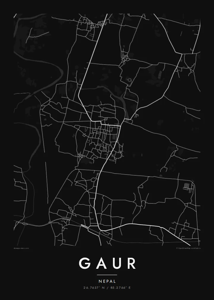
The Nepal–India boundary lies at the southern edge of Gaur, and the neighbouring Indian town is close enough that the two settlements nearly meet on the map.
Minimalist map poster · Nepal
26.7637° N / 85.2766° E
A district headquarters on Nepal's Terai plain, built right up to the Indian border, with flat farmland in every direction.



One city, five moods
Ekamowa emwit style ouga bwe ouga ekamowa e dedaña ñan bwega. Style otata a kor eangan — eprint, eframe ke HD files.
 Pixel ekwan · 24 × 36″ print file
Print-sharp
Enin 100% crop eo mai print file eo elango. Poster otata — eprint, eframe ke edownload — erender iaan server bwir e 300 DPI, dedaña ñan 7,200 × 10,800 pixels, bwe lane ekekedik ekwan ebwe crisp iaan print 24 × 36″.
Ituro


The map
Gaur is the headquarters of Rautahat District in Madhesh Province, in the flat Terai lowlands of southern Nepal. The town sits directly on the border with the Indian state of Bihar. On the map the boundary runs along its southern edge, with the town of Bairgania close by on the Indian side, and that closeness defines the place.
The land around Gaur is almost perfectly flat, part of the great Gangetic plain. Rivers flowing down from the hills to the north cross the district in broad, shifting channels, and the countryside is a dense pattern of fields, ponds and villages linked by narrow roads. The town's own streets form a compact core, with markets and government offices at its centre.
A Gaur map poster shows the Terai as it looks from above: a fine, even texture of farmland and settlements, broken by river courses and by the line of the international border. In black and white the effect is calm and precise, a portrait of an ordinary but important town on one of South Asia's most open borders.
The Nepal–India boundary lies at the southern edge of Gaur, and the neighbouring Indian town is close enough that the two settlements nearly meet on the map.
Rivers draining the hills to the north cross the plain in wide, braided courses, adding sweeping lines to an otherwise flat, finely divided landscape.
Small ponds, field plots and village clusters fill the countryside, giving the Terai its characteristic dotted, patterned appearance in black and white.
Make it yours
Add a date, a name or a line of your own, switch style, size or orientation.
Preview ededa low-resolution im watermark. Print im HD files erender iaan 300 DPI, dedaña ñan 7,200 × 10,800 px, ededa watermark.
Why Gaur
People from Rautahat often live and work far from home, in Kathmandu, in India or in the Gulf. A map of Gaur brings back the streets, markets and fields of the district headquarters in a single image.
Write your own title, add a subtitle and edit the coordinates line, then pick Classic black & white, Noir, Paper, Blueprint or Sand. A free 900 px preview is available before you buy the $9 HD files.
Oder poster Gaur| Print size | Resolution | Files |
|---|---|---|
| 30 × 40 cm (11.8 × 15.7″) | 3,543 × 4,724 px | PNG · PDF |
| 29.7 × 42 cm (A3, 11.7 × 16.5″) | 3,508 × 4,961 px | PNG · PDF |
| 42 × 59.4 cm (A2, 16.5 × 23.4″) | 4,961 × 7,016 px | PNG · PDF |
| 45.7 × 61 cm (18 × 24″) | 5,400 × 7,200 px | PNG · PDF |
| 50 × 70 cm (19.7 × 27.6″) | 5,906 × 8,268 px | PNG · PDF |
| 61 × 91.4 cm (24 × 36″) | 7,200 × 10,800 px | PNG · PDF |
For comparison, the free preview is 900 px wide, watermarked and meant for screens. The HD files have up to 8× the resolution in each direction and print cleanly at full poster size.
Emwit style iaan capña page, im dogen Printed Poster — size eo, im framme ouga tomwin — ke Digital HD Files. Checkout eaer sit step, im order page bwira eupdate iaan payment eo emej.
Eprint iaan matte paper 200 gsm, iaan size eo eo, mai 30 × 40 cm ñan 24 × 36″. Poster eprint eo emeja iaan $39, shipping ededo.
Eko. Emwit frame wood solid iaan black, white, oak natural ke wood dark. Etaña shatterproof glazing im ready ñan hang. Poster eframe emeja iaan $99, shipping ededo.
Eaeoen e ngaaba ngeni ouwa age ngaabe. Ngaeo poster e ibiyaneo ibon e print partner eg ibom ngaen ingi ngae 30+ eben, e naeo e yan ngaae e 3–7 aon wan ewa. Kom ngaa e eain ingi tracking ibon My Orders. Tauweo ebe 2–5 wik, ingi ibon ngaen ibun e ngaeo ngaeigie, e saet e sooe nuwe kom e pae.
Kabun photo bwira iaan 14 aean mai delivery, im bwira ereprint ededo ke erefund.
Eko. Iaan editor page eanin, ouga change title, subtitle, im coordinates line ñan tomwin ouga koda, im emwit style im size. Order eprint, eframe im digital otata ekamowa design ouga tomwin.
Iaan $9 ouga ereub 300 DPI PNG im PDF print-ready iaan size otata eo, ededa watermark, ñan print ekamowa tomwin. Ouga aewedik? Download preview ededa watermarked kabun.
