Parasio quarter
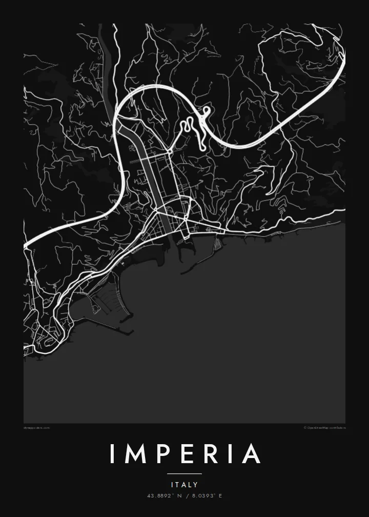
Porto Maurizio's old quarter crowns its promontory with a dense tangle of stepped lanes and alleys, one of the most intricate patches of streets on the whole poster.
Minimalist map poster · Italy
43.8892° N / 8.0393° E
Two old towns on the Ligurian coast, Porto Maurizio and Oneglia, joined across the mouth of the Impero river.



One city, five moods
Ekamowa emwit style ouga bwe ouga ekamowa e dedaña ñan bwega. Style otata a kor eangan — eprint, eframe ke HD files.
 Pixel ekwan · 24 × 36″ print file
Print-sharp
Enin 100% crop eo mai print file eo elango. Poster otata — eprint, eframe ke edownload — erender iaan server bwir e 300 DPI, dedaña ñan 7,200 × 10,800 pixels, bwe lane ekekedik ekwan ebwe crisp iaan print 24 × 36″.
Ituro


The map
Imperia was created in 1923 by joining two separate towns on the western Riviera, Porto Maurizio and Oneglia, together with several smaller villages. The Impero river, which gave the new city its name, flows between them to the sea. A century later the two halves still have distinct characters, and on a map they read as two centres rather than one.
Porto Maurizio climbs a rocky promontory. Its old quarter, the Parasio, is a knot of steep lanes around the hilltop, and the large neoclassical Basilica of San Maurizio stands close by. Oneglia, to the east, is flatter and more regular, with an arcaded street, a working harbour and a history tied to olive oil and pasta-making. Terraced olive groves cover the hills above both.
An Imperia map poster brings out that double structure very clearly. Two harbours, two old centres and a river mouth between them sit along a curving stretch of Mediterranean coast, with steep hinterland behind. It is a thoughtful choice for anyone who has spent summers on the Riviera di Ponente or has family roots in either town.
Porto Maurizio's old quarter crowns its promontory with a dense tangle of stepped lanes and alleys, one of the most intricate patches of streets on the whole poster.
Oneglia's port and the arcaded streets behind it form a flatter, more orderly pattern, historically linked to the olive oil trade that shaped the town's economy.
The short river that gave the city its name reaches the sea between the two towns. It is a clear dividing line that explains Imperia's unusual two-centred shape.
Make it yours
Add a date, a name or a line of your own, switch style, size or orientation.
Preview ededa low-resolution im watermark. Print im HD files erender iaan 300 DPI, dedaña ñan 7,200 × 10,800 px, ededa watermark.
Why Imperia
Imperia rewards people who know it well: the walk between the two harbours, the climb into the Parasio, the olive terraces above the coast. A map poster keeps all of those places together in one clean, legible image.
You can title it Imperia or name one of its two halves, add a date or a line of your own, and choose from five styles. The digital files come in six sizes, including 50×70 cm, A2 and 24×36″, with no watermark.
Oder poster Imperia| Print size | Resolution | Files |
|---|---|---|
| 30 × 40 cm11.8 × 15.7″ | 3,543 × 4,724 px | PNG · PDF |
| 29.7 × 42 cm (A3)11.7 × 16.5″ | 3,508 × 4,961 px | PNG · PDF |
| 42 × 59.4 cm (A2)16.5 × 23.4″ | 4,961 × 7,016 px | PNG · PDF |
| 45.7 × 61 cm18 × 24″ | 5,400 × 7,200 px | PNG · PDF |
| 50 × 70 cm19.7 × 27.6″ | 5,906 × 8,268 px | PNG · PDF |
| 61 × 91.4 cm24 × 36″ | 7,200 × 10,800 px | PNG · PDF |
For comparison, the free preview is 900 px wide, watermarked and meant for screens. The HD files have up to 8× the resolution in each direction and print cleanly at full poster size.
Emwit style iaan capña page, im dogen Printed Poster — size eo, im framme ouga tomwin — ke Digital HD Files. Checkout eaer sit step, im order page bwira eupdate iaan payment eo emej.
Eprint iaan matte paper 200 gsm, iaan size eo eo, mai 30 × 40 cm ñan 24 × 36″. Poster eprint eo emeja iaan $39, shipping ededo.
Eko. Emwit frame wood solid iaan black, white, oak natural ke wood dark. Etaña shatterproof glazing im ready ñan hang. Poster eframe emeja iaan $99, shipping ededo.
Shipping ma free ägen 60+ country. Poster ngaga eo e print ägen print partner nearest ibiema 30+ country, ae e tep ägen 3–7 business day. Ngaga kor status ae tracking ibe My Orders. Country ibiema e tep 2–5 week, ae country ngaga ibe shipping e bwaren, website e ibin oen bwa ngaga pay.
Kabun photo bwira iaan 14 aean mai delivery, im bwira ereprint ededo ke erefund.
Eko. Iaan editor page eanin, ouga change title, subtitle, im coordinates line ñan tomwin ouga koda, im emwit style im size. Order eprint, eframe im digital otata ekamowa design ouga tomwin.
Iaan $9 ouga ereub 300 DPI PNG im PDF print-ready iaan size otata eo, ededa watermark, ñan print ekamowa tomwin. Ouga aewedik? Download preview ededa watermarked kabun.
