Niger–Benue confluence
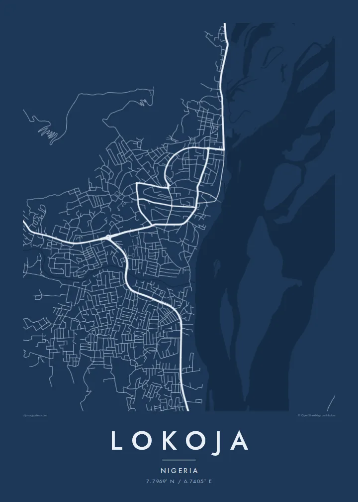
The meeting of Nigeria's two largest rivers dominates the map, a broad Y of open water with sandbars and islands that makes the town's position instantly recognisable.
Minimalist map poster · Nigeria
7.7969° N / 6.7405° E
Two great rivers meet in a wide Y beneath a flat-topped hill, with the town strung along the western bank.



One city, five moods
Ekamowa emwit style ouga bwe ouga ekamowa e dedaña ñan bwega. Style otata a kor eangan — eprint, eframe ke HD files.
 Pixel ekwan · 24 × 36″ print file
Print-sharp
Enin 100% crop eo mai print file eo elango. Poster otata — eprint, eframe ke edownload — erender iaan server bwir e 300 DPI, dedaña ñan 7,200 × 10,800 pixels, bwe lane ekekedik ekwan ebwe crisp iaan print 24 × 36″.
Ituro


The map
Lokoja sits where the Niger and the Benue join, and on a map that confluence is the whole composition. Two broad channels arrive from the north-west and north-east, merge into a single river flowing south, and leave sandbanks and braided islands in their wake. The town itself runs along the west bank in a narrow band, held between the water and the rising ground behind it.
Above the streets, Mount Patti climbs steeply, its plateau top reached by winding roads and tracks. The hill is tied to a widely told story: the name Nigeria is said to have been coined while looking out over this confluence. Lokoja also served as an early administrative centre under British rule, and today it is the capital of Kogi State, a crossroads between the north and south of the country.
A Lokoja map poster reduces all of this to line and space: the dense streets near the river, the highway threading north towards Abuja, and the pale expanse of water that fills much of the frame. Few city maps are so clearly organised around one natural event, and the result reads almost like a diagram of how rivers shape the places that grow beside them.
The meeting of Nigeria's two largest rivers dominates the map, a broad Y of open water with sandbars and islands that makes the town's position instantly recognisable.
The steep hill rising directly behind the town appears as a tight knot of winding roads, a strong contrast to the flat river plain spread out below it.
Squeezed between hill and water, Lokoja's streets form a long, narrow band that follows the west bank, with newer growth pushing along the main roads.
Make it yours
Add a date, a name or a line of your own, switch style, size or orientation.
Preview ededa low-resolution im watermark. Print im HD files erender iaan 300 DPI, dedaña ñan 7,200 × 10,800 px, ededa watermark.
Why Lokoja
For people from Kogi State, or anyone who has crossed the confluence, this map holds a sense of arrival: the point where two rivers and several highways come together. It works as a quiet reminder of home, a posting, a journey or a family story tied to the town.
You can set your own title, subtitle and coordinates line, adding a date or a name, and choose from Classic black & white, Noir, Paper, Blueprint or Sand. The HD files cost $9 and arrive without a watermark, or you can order a matte print from partners in more than 30 countries.
Oder poster Lokoja| Print size | Resolution | Files |
|---|---|---|
| 30 × 40 cm11.8 × 15.7″ | 3,543 × 4,724 px | PNG · PDF |
| 29.7 × 42 cm (A3)11.7 × 16.5″ | 3,508 × 4,961 px | PNG · PDF |
| 42 × 59.4 cm (A2)16.5 × 23.4″ | 4,961 × 7,016 px | PNG · PDF |
| 45.7 × 61 cm18 × 24″ | 5,400 × 7,200 px | PNG · PDF |
| 50 × 70 cm19.7 × 27.6″ | 5,906 × 8,268 px | PNG · PDF |
| 61 × 91.4 cm24 × 36″ | 7,200 × 10,800 px | PNG · PDF |
For comparison, the free preview is 900 px wide, watermarked and meant for screens. The HD files have up to 8× the resolution in each direction and print cleanly at full poster size.
Emwit style iaan capña page, im dogen Printed Poster — size eo, im framme ouga tomwin — ke Digital HD Files. Checkout eaer sit step, im order page bwira eupdate iaan payment eo emej.
Eprint iaan matte paper 200 gsm, iaan size eo eo, mai 30 × 40 cm ñan 24 × 36″. Poster eprint eo emeja iaan $39, shipping ededo.
Eko. Emwit frame wood solid iaan black, white, oak natural ke wood dark. Etaña shatterproof glazing im ready ñan hang. Poster eframe emeja iaan $99, shipping ededo.
Shipping ma free ägen 60+ country. Poster ngaga eo e print ägen print partner nearest ibiema 30+ country, ae e tep ägen 3–7 business day. Ngaga kor status ae tracking ibe My Orders. Country ibiema e tep 2–5 week, ae country ngaga ibe shipping e bwaren, website e ibin oen bwa ngaga pay.
Kabun photo bwira iaan 14 aean mai delivery, im bwira ereprint ededo ke erefund.
Eko. Iaan editor page eanin, ouga change title, subtitle, im coordinates line ñan tomwin ouga koda, im emwit style im size. Order eprint, eframe im digital otata ekamowa design ouga tomwin.
Iaan $9 ouga ereub 300 DPI PNG im PDF print-ready iaan size otata eo, ededa watermark, ñan print ekamowa tomwin. Ouga aewedik? Download preview ededa watermarked kabun.
