The Presqu'île
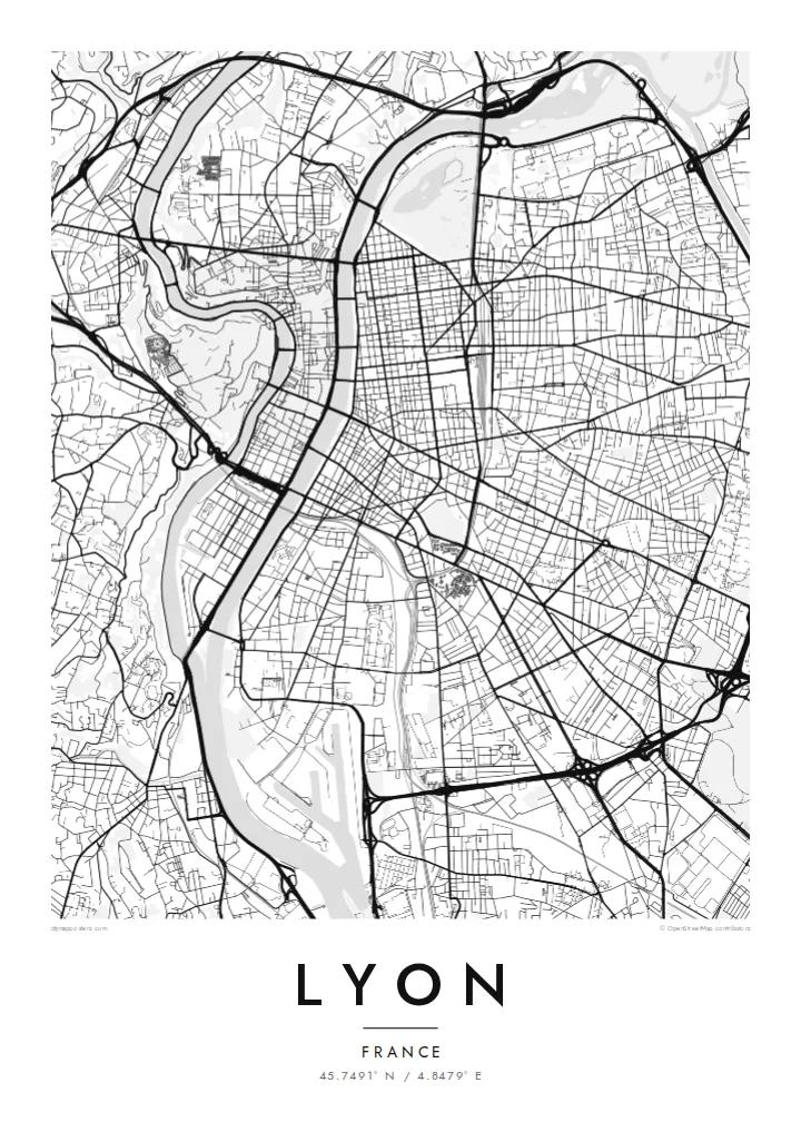
The peninsula between the Rhône and Saône holds a dense, elongated centre with Place Bellecour at its heart, framed on both sides by quays and a steady rhythm of bridges.
Minimalist map poster · France
45.7491° N / 4.8479° E
Two rivers, two hills and a narrow peninsula between them: the Rhône and Saône give Lyon one of France's clearest city maps.


One city, five moods
Ekamowa emwit style ouga bwe ouga ekamowa e dedaña ñan bwega. Style otata a kor eangan — eprint, eframe ke HD files.
 Pixel ekwan · 24 × 36″ print file
Print-sharp
Enin 100% crop eo mai print file eo elango. Poster otata — eprint, eframe ke edownload — erender iaan server bwir e 300 DPI, dedaña ñan 7,200 × 10,800 pixels, bwe lane ekekedik ekwan ebwe crisp iaan print 24 × 36″.
Ituro


The map
Lyon is built where the Saône meets the Rhône, and the two rivers give the city an unusually legible shape. Between them runs the Presqu'île, a long, narrow peninsula that holds the historic commercial centre, Place Bellecour and the Hôtel de Ville. At its southern tip, the former docklands of Confluence have been rebuilt as a modern district where the two rivers meet.
West of the Saône, Fourvière hill rises steeply above Vieux Lyon. Its basilica can be seen from across the city, and its slopes hold the remains of Roman Lugdunum, once a capital of Gaul. North of the Presqu'île, the Croix-Rousse hill was home to the silk weavers, whose covered passageways, the traboules, still run through buildings and courtyards. The historic centre is a UNESCO World Heritage Site.
East of the Rhône the city opens into a broader grid, and Parc de la Tête d'Or, one of the largest urban parks in France, curves along the riverbank. A Lyon map poster shows all of this at once: bridges linking the banks, hills pressing against the old town and the orderly east bank spreading toward the plain.
The peninsula between the Rhône and Saône holds a dense, elongated centre with Place Bellecour at its heart, framed on both sides by quays and a steady rhythm of bridges.
On the west bank, the medieval streets of Vieux Lyon are squeezed between the Saône and the steep slope of Fourvière, where winding roads climb to the basilica.
The large park on the left bank of the Rhône shows as a broad open area with a lake, a clear green anchor against the regular blocks of the east side.
Make it yours
Add a date, a name or a line of your own, switch style, size or orientation.
Preview ededa low-resolution im watermark. Print im HD files erender iaan 300 DPI, dedaña ñan 7,200 × 10,800 px, ededa watermark.
Why Lyon
People come to Lyon to study, eat and work, and many stay longer than planned. A map of its rivers and hills is a quiet reminder of an apartment on the Croix-Rousse slope, a café on the Presqu'île or a first job near Part-Dieu station.
Set the title and subtitle to anything you like, from an arrondissement to the day you arrived, and edit the coordinates line. Each of the five styles, Classic black & white, Noir, Paper, Blueprint and Sand, shows Lyon's rivers differently. HD files cost $9, and prints ship from partners in 30+ countries.
Oder poster Lyon| Print size | Resolution | Files |
|---|---|---|
| 30 × 40 cm11.8 × 15.7″ | 3,543 × 4,724 px | PNG · PDF |
| 29.7 × 42 cm (A3)11.7 × 16.5″ | 3,508 × 4,961 px | PNG · PDF |
| 42 × 59.4 cm (A2)16.5 × 23.4″ | 4,961 × 7,016 px | PNG · PDF |
| 45.7 × 61 cm18 × 24″ | 5,400 × 7,200 px | PNG · PDF |
| 50 × 70 cm19.7 × 27.6″ | 5,906 × 8,268 px | PNG · PDF |
| 61 × 91.4 cm24 × 36″ | 7,200 × 10,800 px | PNG · PDF |
For comparison, the free preview is 900 px wide, watermarked and meant for screens. The HD files have up to 8× the resolution in each direction and print cleanly at full poster size.
Emwit style iaan capña page, im dogen Printed Poster — size eo, im framme ouga tomwin — ke Digital HD Files. Checkout eaer sit step, im order page bwira eupdate iaan payment eo emej.
Eprint iaan matte paper 200 gsm, iaan size eo eo, mai 30 × 40 cm ñan 24 × 36″. Poster eprint eo emeja iaan $39, shipping ededo.
Eko. Emwit frame wood solid iaan black, white, oak natural ke wood dark. Etaña shatterproof glazing im ready ñan hang. Poster eframe emeja iaan $99, shipping ededo.
Shipping ma free ägen 60+ country. Poster ngaga eo e print ägen print partner nearest ibiema 30+ country, ae e tep ägen 3–7 business day. Ngaga kor status ae tracking ibe My Orders. Country ibiema e tep 2–5 week, ae country ngaga ibe shipping e bwaren, website e ibin oen bwa ngaga pay.
Kabun photo bwira iaan 14 aean mai delivery, im bwira ereprint ededo ke erefund.
Eko. Iaan editor page eanin, ouga change title, subtitle, im coordinates line ñan tomwin ouga koda, im emwit style im size. Order eprint, eframe im digital otata ekamowa design ouga tomwin.
Iaan $9 ouga ereub 300 DPI PNG im PDF print-ready iaan size otata eo, ededa watermark, ñan print ekamowa tomwin. Ouga aewedik? Download preview ededa watermarked kabun.
