The Solimões River
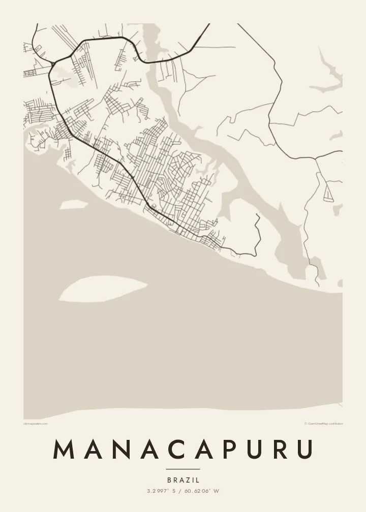
The river runs along the town's edge and covers a large part of the composition. Its width makes the built area look small and deliberate.
Minimalist map poster · Brazil
3.2997° S / 60.6206° W
An Amazon river town on the Solimões, its streets bordered by wide water, lakes and flooded forest.




One city, five moods
Ekamowa emwit style ouga bwe ouga ekamowa e dedaña ñan bwega. Style otata a kor eangan — eprint, eframe ke HD files.
 Pixel ekwan · 24 × 36″ print file
Print-sharp
Enin 100% crop eo mai print file eo elango. Poster otata — eprint, eframe ke edownload — erender iaan server bwir e 300 DPI, dedaña ñan 7,200 × 10,800 pixels, bwe lane ekekedik ekwan ebwe crisp iaan print 24 × 36″.
Ituro


The map
Manacapuru lies west of Manaus on the left bank of the Solimões, as the upper Amazon is called in Brazil. The river here is enormous, and on a map the town is a modest pattern of streets against very large areas of water and forest. It is one of the larger towns in the state of Amazonas outside the capital.
The town is best known for its Festival de Cirandas, an annual celebration in which rival groups perform elaborate dance and music. Its economy is tied to the river: fishing, transport and trade with the communities spread along the waterways. Road connection to Manaus crosses the Rio Negro bridge.
A Manacapuru map poster shows how completely water shapes the place. The street grid stops at the riverbank, while lakes and channels cut into the land from several directions. What looks like open space on the page is mostly river and seasonally flooded forest.
The river runs along the town's edge and covers a large part of the composition. Its width makes the built area look small and deliberate.
Lakes and side channels reach toward the town. Their irregular outlines cut into the street pattern and change noticeably between the wet and dry seasons.
Close to the water, the streets form a simple, fairly regular grid. It is a clear, readable layout typical of Amazonian towns built along the river.
Make it yours
Add a date, a name or a line of your own, switch style, size or orientation.
Preview ededa low-resolution im watermark. Print im HD files erender iaan 300 DPI, dedaña ñan 7,200 × 10,800 px, ededa watermark.
Why Manacapuru
Manacapuru is for those who know the river, the festival or the ferry routes, and for anyone drawn to a place defined by water. It makes an unusual, spacious wall piece.
Personalise the title, subtitle and coordinates line, and choose Classic black & white, Noir, Paper, Blueprint or Sand. Noir gives the river a striking depth. Files are available immediately as HD downloads, or as printed posters shipped from local partners.
Oder poster Manacapuru| Print size | Resolution | Files |
|---|---|---|
| 30 × 40 cm11.8 × 15.7″ | 3,543 × 4,724 px | PNG · PDF |
| 29.7 × 42 cm (A3)11.7 × 16.5″ | 3,508 × 4,961 px | PNG · PDF |
| 42 × 59.4 cm (A2)16.5 × 23.4″ | 4,961 × 7,016 px | PNG · PDF |
| 45.7 × 61 cm18 × 24″ | 5,400 × 7,200 px | PNG · PDF |
| 50 × 70 cm19.7 × 27.6″ | 5,906 × 8,268 px | PNG · PDF |
| 61 × 91.4 cm24 × 36″ | 7,200 × 10,800 px | PNG · PDF |
For comparison, the free preview is 900 px wide, watermarked and meant for screens. The HD files have up to 8× the resolution in each direction and print cleanly at full poster size.
Emwit style iaan capña page, im dogen Printed Poster — size eo, im framme ouga tomwin — ke Digital HD Files. Checkout eaer sit step, im order page bwira eupdate iaan payment eo emej.
Eprint iaan matte paper 200 gsm, iaan size eo eo, mai 30 × 40 cm ñan 24 × 36″. Poster eprint eo emeja iaan $39, shipping ededo.
Eko. Emwit frame wood solid iaan black, white, oak natural ke wood dark. Etaña shatterproof glazing im ready ñan hang. Poster eframe emeja iaan $99, shipping ededo.
Shipping ma free ägen 60+ country. Poster ngaga eo e print ägen print partner nearest ibiema 30+ country, ae e tep ägen 3–7 business day. Ngaga kor status ae tracking ibe My Orders. Country ibiema e tep 2–5 week, ae country ngaga ibe shipping e bwaren, website e ibin oen bwa ngaga pay.
Kabun photo bwira iaan 14 aean mai delivery, im bwira ereprint ededo ke erefund.
Eko. Iaan editor page eanin, ouga change title, subtitle, im coordinates line ñan tomwin ouga koda, im emwit style im size. Order eprint, eframe im digital otata ekamowa design ouga tomwin.
Iaan $9 ouga ereub 300 DPI PNG im PDF print-ready iaan size otata eo, ededa watermark, ñan print ekamowa tomwin. Ouga aewedik? Download preview ededa watermarked kabun.
