Transport interchange
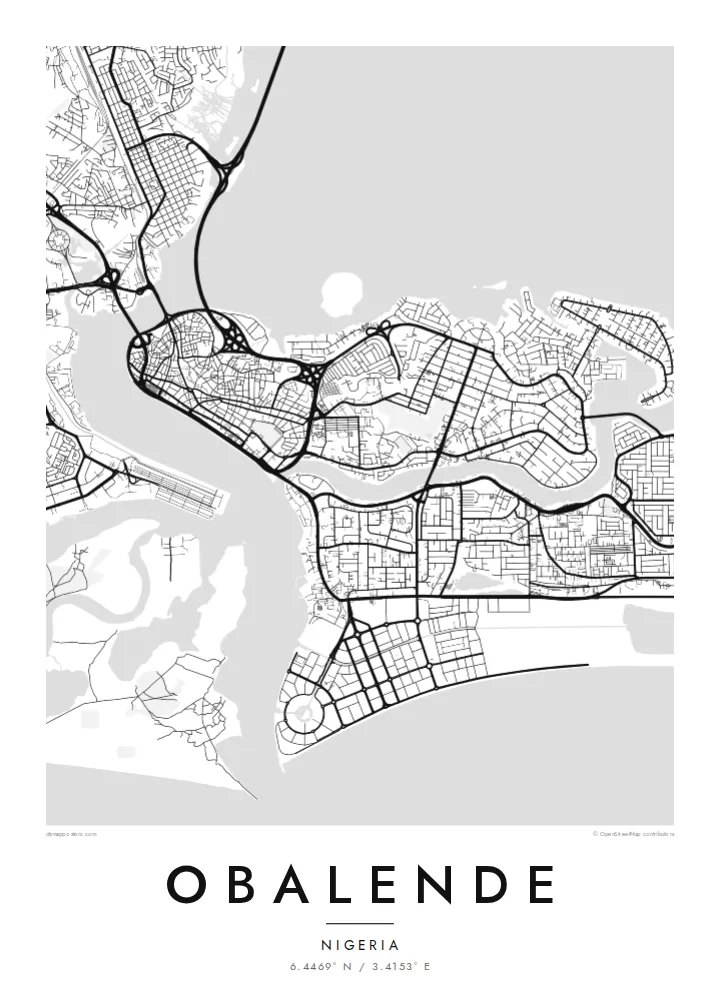
Roads converge on Obalende from several directions, forming loops and junctions that serve one of the busiest bus and commuter hubs in Lagos.
Minimalist map poster · Nigeria
6.4469° N / 3.4153° E
A transit district on the eastern side of Lagos Island, framed by lagoon water, bridge approaches and the leafy streets of Ikoyi.


One city, five moods
Ekamowa emwit style ouga bwe ouga ekamowa e dedaña ñan bwega. Style otata a kor eangan — eprint, eframe ke HD files.
 Pixel ekwan · 24 × 36″ print file
Print-sharp
Enin 100% crop eo mai print file eo elango. Poster otata — eprint, eframe ke edownload — erender iaan server bwir e 300 DPI, dedaña ñan 7,200 × 10,800 pixels, bwe lane ekekedik ekwan ebwe crisp iaan print 24 × 36″.
Ituro


The map
Obalende sits where Lagos Island meets Ikoyi, and on a map it looks like a hinge between two very different street patterns. To the west lie the tight, irregular lanes of the old island centre; to the east, the wider, curving roads of Ikoyi. Obalende itself is dense and busy, organised around roads that feed traffic toward the bridges and the mainland.
The area is best known as one of the city's major transport hubs, where buses, minibuses and motorcycles gather before heading across the lagoon or along the islands. That role is visible from above in the way roads converge, split and loop around interchanges, creating a knot of lines that stands out against the finer grain of nearby residential blocks.
An Obalende map poster captures a small area with an outsized role in daily Lagos life. Framed closely, it shows the meeting of island, lagoon and highway; framed wider, it places the district within the watery geography of Lagos Island and Ikoyi. Either way, the black and white rendering turns a noisy junction into a calm study of movement.
Roads converge on Obalende from several directions, forming loops and junctions that serve one of the busiest bus and commuter hubs in Lagos.
The district marks the transition from the dense, irregular lanes of Lagos Island to the broader, curving residential roads of Ikoyi, a contrast clear at any scale.
Water frames the wider view on several sides, with lagoon channels and bridge approaches giving the map strong, clean boundaries around the built-up land.
Make it yours
Add a date, a name or a line of your own, switch style, size or orientation.
Preview ededa low-resolution im watermark. Print im HD files erender iaan 300 DPI, dedaña ñan 7,200 × 10,800 px, ededa watermark.
Why Obalende
For anyone who has commuted through Lagos, Obalende is a familiar point on the daily route, a place of departures and arrivals. A map of it is a small tribute to those journeys and to the island geography that shapes the whole city.
Set your own title, subtitle and coordinates line, and choose between Classic black and white, Noir, Paper, Blueprint and Sand. Files come as 300 DPI PNG and print-ready PDF in six sizes for $9, or order a matte printed poster shipped from a partner near you.
Oder poster Obalende| Print size | Resolution | Files |
|---|---|---|
| 30 × 40 cm (11.8 × 15.7″) | 3,543 × 4,724 px | PNG · PDF |
| 29.7 × 42 cm (A3, 11.7 × 16.5″) | 3,508 × 4,961 px | PNG · PDF |
| 42 × 59.4 cm (A2, 16.5 × 23.4″) | 4,961 × 7,016 px | PNG · PDF |
| 45.7 × 61 cm (18 × 24″) | 5,400 × 7,200 px | PNG · PDF |
| 50 × 70 cm (19.7 × 27.6″) | 5,906 × 8,268 px | PNG · PDF |
| 61 × 91.4 cm (24 × 36″) | 7,200 × 10,800 px | PNG · PDF |
For comparison, the free preview is 900 px wide, watermarked and meant for screens. The HD files have up to 8× the resolution in each direction and print cleanly at full poster size.
Emwit style iaan capña page, im dogen Printed Poster — size eo, im framme ouga tomwin — ke Digital HD Files. Checkout eaer sit step, im order page bwira eupdate iaan payment eo emej.
Eprint iaan matte paper 200 gsm, iaan size eo eo, mai 30 × 40 cm ñan 24 × 36″. Poster eprint eo emeja iaan $39, shipping ededo.
Eko. Emwit frame wood solid iaan black, white, oak natural ke wood dark. Etaña shatterproof glazing im ready ñan hang. Poster eframe emeja iaan $99, shipping ededo.
Eaeoen e ngaaba ngeni ouwa age ngaabe. Ngaeo poster e ibiyaneo ibon e print partner eg ibom ngaen ingi ngae 30+ eben, e naeo e yan ngaae e 3–7 aon wan ewa. Kom ngaa e eain ingi tracking ibon My Orders. Tauweo ebe 2–5 wik, ingi ibon ngaen ibun e ngaeo ngaeigie, e saet e sooe nuwe kom e pae.
Kabun photo bwira iaan 14 aean mai delivery, im bwira ereprint ededo ke erefund.
Eko. Iaan editor page eanin, ouga change title, subtitle, im coordinates line ñan tomwin ouga koda, im emwit style im size. Order eprint, eframe im digital otata ekamowa design ouga tomwin.
Iaan $9 ouga ereub 300 DPI PNG im PDF print-ready iaan size otata eo, ededa watermark, ñan print ekamowa tomwin. Ouga aewedik? Download preview ededa watermarked kabun.
