River confluence
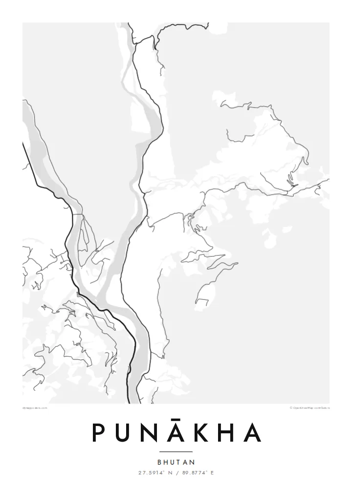
The Pho Chhu and Mo Chhu, often called the father and mother rivers, join just below the dzong and continue down the valley as a single, wider channel.
Minimalist map poster · Bhutan
27.5914° N / 89.8774° E
Two glacial rivers meeting on a warm valley floor, with a fortress set on the point of land where they join.


One city, five moods
Ekamowa emwit style ouga bwe ouga ekamowa e dedaña ñan bwega. Style otata a kor eangan — eprint, eframe ke HD files.
 Pixel ekwan · 24 × 36″ print file
Print-sharp
Enin 100% crop eo mai print file eo elango. Poster otata — eprint, eframe ke edownload — erender iaan server bwir e 300 DPI, dedaña ñan 7,200 × 10,800 pixels, bwe lane ekekedik ekwan ebwe crisp iaan print 24 × 36″.
Ituro


The map
Punākha sits low for Bhutan, in a broad valley at around 1,200 metres where the Pho Chhu and the Mo Chhu flow together. From above, the two rivers make up most of the picture: pale ribbons braiding across gravel bars, then merging into one channel that heads south. Roads keep to the valley sides, and houses gather on the few flat terraces the slopes allow.
On the narrow spit between the rivers stands Punākha Dzong. This fortress-monastery was the seat of government while Punākha served as Bhutan's capital, a role it held until the 1950s, and it is still the winter residence of the country's central monastic body. On the map the dzong is a compact block pressed against the water, reached by a covered bridge across the Mo Chhu.
A Punākha map poster keeps that geography plain. There is no dense grid to fill the frame, so the rivers, the valley road and the scattered lanes of the modern town carry the drawing. The result is quieter than most city maps and closer to a landscape study, with the confluence as its natural centre of gravity.
The Pho Chhu and Mo Chhu, often called the father and mother rivers, join just below the dzong and continue down the valley as a single, wider channel.
The fortress fills the tip of land between the two rivers. Its position makes it one of the most recognisable shapes on any map of the valley.
Near the dzong, a long pedestrian suspension bridge crosses the Pho Chhu. It is a thin, taut line on the map linking the paths and villages on either bank.
Make it yours
Add a date, a name or a line of your own, switch style, size or orientation.
Preview ededa low-resolution im watermark. Print im HD files erender iaan 300 DPI, dedaña ñan 7,200 × 10,800 px, ededa watermark.
Why Punākha
People who have walked or travelled through western Bhutan often want something that recalls the whole valley rather than a single photograph. A map of Punākha does this with line alone: two rivers, one fortress and a road following the water. It suits a study, a hallway or any corner where detail can be read slowly.
You can set your own title and subtitle, and replace the coordinates line with a date or a note about the journey. There are five styles: Classic black & white, Noir, Paper, Blueprint and Sand. Paper and Sand suit the softer valley light. Download the HD files for $9 or order a matte print, framed or unframed.
Oder poster Punākha| Print size | Resolution | Files |
|---|---|---|
| 30 × 40 cm11.8 × 15.7″ | 3,543 × 4,724 px | PNG · PDF |
| 29.7 × 42 cm (A3)11.7 × 16.5″ | 3,508 × 4,961 px | PNG · PDF |
| 42 × 59.4 cm (A2)16.5 × 23.4″ | 4,961 × 7,016 px | PNG · PDF |
| 45.7 × 61 cm18 × 24″ | 5,400 × 7,200 px | PNG · PDF |
| 50 × 70 cm19.7 × 27.6″ | 5,906 × 8,268 px | PNG · PDF |
| 61 × 91.4 cm24 × 36″ | 7,200 × 10,800 px | PNG · PDF |
For comparison, the free preview is 900 px wide, watermarked and meant for screens. The HD files have up to 8× the resolution in each direction and print cleanly at full poster size.
Emwit style iaan capña page, im dogen Printed Poster — size eo, im framme ouga tomwin — ke Digital HD Files. Checkout eaer sit step, im order page bwira eupdate iaan payment eo emej.
Eprint iaan matte paper 200 gsm, iaan size eo eo, mai 30 × 40 cm ñan 24 × 36″. Poster eprint eo emeja iaan $39, shipping ededo.
Eko. Emwit frame wood solid iaan black, white, oak natural ke wood dark. Etaña shatterproof glazing im ready ñan hang. Poster eframe emeja iaan $99, shipping ededo.
Shipping ma free ägen 60+ country. Poster ngaga eo e print ägen print partner nearest ibiema 30+ country, ae e tep ägen 3–7 business day. Ngaga kor status ae tracking ibe My Orders. Country ibiema e tep 2–5 week, ae country ngaga ibe shipping e bwaren, website e ibin oen bwa ngaga pay.
Kabun photo bwira iaan 14 aean mai delivery, im bwira ereprint ededo ke erefund.
Eko. Iaan editor page eanin, ouga change title, subtitle, im coordinates line ñan tomwin ouga koda, im emwit style im size. Order eprint, eframe im digital otata ekamowa design ouga tomwin.
Iaan $9 ouga ereub 300 DPI PNG im PDF print-ready iaan size otata eo, ededa watermark, ñan print ekamowa tomwin. Ouga aewedik? Download preview ededa watermarked kabun.
