Airfield runway
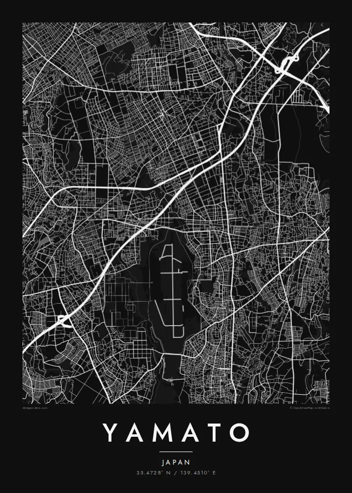
The long runway on the southern edge of the city forms a stark straight line and a large open space, one of the most recognisable shapes on any map of Yamato.
Minimalist map poster · Japan
35.4728° N / 139.4510° E
A dense residential city on the Sagami Plateau, cut by rail lines and edged by a long runway to the south



One city, five moods
Ekamowa emwit style ouga bwe ouga ekamowa e dedaña ñan bwega. Style otata a kor eangan — eprint, eframe ke HD files.
 Pixel ekwan · 24 × 36″ print file
Print-sharp
Enin 100% crop eo mai print file eo elango. Poster otata — eprint, eframe ke edownload — erender iaan server bwir e 300 DPI, dedaña ñan 7,200 × 10,800 pixels, bwe lane ekekedik ekwan ebwe crisp iaan print 24 × 36″.
Ituro


The map
Yamato occupies a narrow strip of the Sagami Plateau in central Kanagawa, and from above it looks like a finely packed mosaic of small lots and winding residential lanes. Several suburban rail lines cross it, each marked by a string of stations around which the streets tighten. There is no single old centre here; instead the city reads as a series of station neighbourhoods joined into one continuous fabric.
The most striking shape on the map is the long straight runway of the Atsugi air facility, which lies across the city's southern boundary and interrupts the dense streets with a clean geometric void. Small rivers run north to south along the plateau, including one that traces the eastern boundary, adding soft curving lines to an otherwise tight grid.
A Yamato map poster captures the texture of commuter-belt Japan at its most characteristic: thousands of short streets, careful green pockets of woodland park and shrine grounds, and railways drawn as firm diagonal strokes. It is a pattern that rewards close looking, because the detail is in the small scale rather than in any one landmark.
The long runway on the southern edge of the city forms a stark straight line and a large open space, one of the most recognisable shapes on any map of Yamato.
Where the rail lines meet their stations, the street grid compresses into small commercial centres, giving the map several focal points instead of a single downtown.
Narrow rivers and their green margins run lengthwise through the city, drawing gentle curves through the otherwise dense and irregular residential street pattern.
Make it yours
Add a date, a name or a line of your own, switch style, size or orientation.
Preview ededa low-resolution im watermark. Print im HD files erender iaan 300 DPI, dedaña ñan 7,200 × 10,800 px, ededa watermark.
Why Yamato
For people who live in or commute through Yamato, the map shows home as it actually is: the lanes walked to the station, the park at the end of the road, the line home from Yokohama or Tokyo. It is a quiet, detailed image that suits a hallway or a study.
The title, subtitle and coordinates can all be changed, so it can mark a first apartment or a family address with a date. Pick one of five styles, from Classic black and white and Noir to Paper, Blueprint and Sand, as a digital download or a framed print.
Oder poster Yamato| Print size | Resolution | Files |
|---|---|---|
| 30 × 40 cm11.8 × 15.7″ | 3,543 × 4,724 px | PNG · PDF |
| 29.7 × 42 cm (A3)11.7 × 16.5″ | 3,508 × 4,961 px | PNG · PDF |
| 42 × 59.4 cm (A2)16.5 × 23.4″ | 4,961 × 7,016 px | PNG · PDF |
| 45.7 × 61 cm18 × 24″ | 5,400 × 7,200 px | PNG · PDF |
| 50 × 70 cm19.7 × 27.6″ | 5,906 × 8,268 px | PNG · PDF |
| 61 × 91.4 cm24 × 36″ | 7,200 × 10,800 px | PNG · PDF |
For comparison, the free preview is 900 px wide, watermarked and meant for screens. The HD files have up to 8× the resolution in each direction and print cleanly at full poster size.
Emwit style iaan capña page, im dogen Printed Poster — size eo, im framme ouga tomwin — ke Digital HD Files. Checkout eaer sit step, im order page bwira eupdate iaan payment eo emej.
Eprint iaan matte paper 200 gsm, iaan size eo eo, mai 30 × 40 cm ñan 24 × 36″. Poster eprint eo emeja iaan $39, shipping ededo.
Eko. Emwit frame wood solid iaan black, white, oak natural ke wood dark. Etaña shatterproof glazing im ready ñan hang. Poster eframe emeja iaan $99, shipping ededo.
Shipping ma free ägen 60+ country. Poster ngaga eo e print ägen print partner nearest ibiema 30+ country, ae e tep ägen 3–7 business day. Ngaga kor status ae tracking ibe My Orders. Country ibiema e tep 2–5 week, ae country ngaga ibe shipping e bwaren, website e ibin oen bwa ngaga pay.
Kabun photo bwira iaan 14 aean mai delivery, im bwira ereprint ededo ke erefund.
Eko. Iaan editor page eanin, ouga change title, subtitle, im coordinates line ñan tomwin ouga koda, im emwit style im size. Order eprint, eframe im digital otata ekamowa design ouga tomwin.
Iaan $9 ouga ereub 300 DPI PNG im PDF print-ready iaan size otata eo, ededa watermark, ñan print ekamowa tomwin. Ouga aewedik? Download preview ededa watermarked kabun.
