Minato Mirai 21
A modern waterfront district built on reclaimed land, with tall towers, open plazas and a large Ferris wheel forming a clean, planned edge along the bay.
Minimalist map poster · Japan
35.4333° N / 139.6500° E
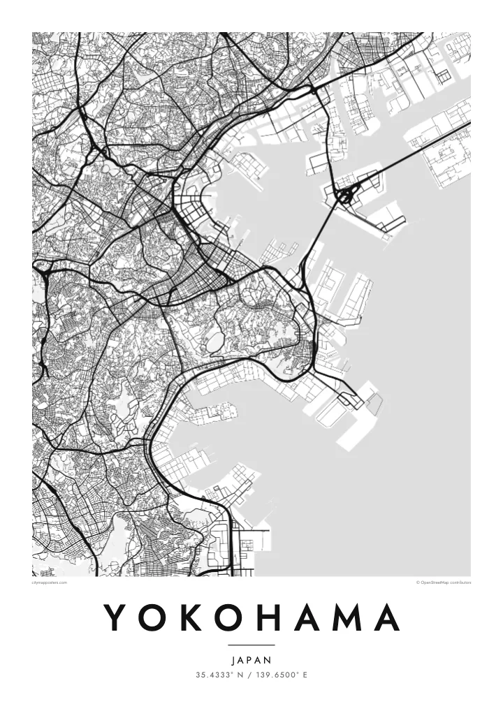
A port city on Tokyo Bay, with a waterfront of piers and reclaimed land and hills rising just behind the harbour.


One city, five moods
Ekamowa emwit style ouga bwe ouga ekamowa e dedaña ñan bwega. Style otata a kor eangan — eprint, eframe ke HD files.
 Pixel ekwan · 24 × 36″ print file
Print-sharp
Enin 100% crop eo mai print file eo elango. Poster otata — eprint, eframe ke edownload — erender iaan server bwir e 300 DPI, dedaña ñan 7,200 × 10,800 pixels, bwe lane ekekedik ekwan ebwe crisp iaan print 24 × 36″.
Ituro


The map
Yokohama faces Tokyo Bay, and from above its waterfront is a line of piers, reclaimed land and container terminals. The older city centre sits close to the harbour, with Yamashita Park running along the shore, while behind it the land climbs quickly into wooded hills. Further inland, residential districts spread across a rolling landscape of valleys and ridges.
The port opened to foreign trade in 1859, and the city grew from a small fishing village into one of the largest cities in Japan. The hill known as the Bluff, or Yamate, became home to foreign residents, and below it Chinatown, the largest in Japan, still fills a tight grid of streets with gates marking its edges.
Minato Mirai 21 added a new waterfront district of towers, museums and a large Ferris wheel on reclaimed land. A Yokohama map poster shows how the harbour, old town, Chinatown and new waterfront sit together, while the Bay Bridge crosses the entrance to the inner port as one of the most graphic lines on the map.
A modern waterfront district built on reclaimed land, with tall towers, open plazas and a large Ferris wheel forming a clean, planned edge along the bay.
The largest Chinatown in Japan fills a compact grid of streets near the harbour, framed by decorative gates that mark its entrances.
A long cable-stayed bridge crosses the harbour entrance, visible on the map as a thin straight line joining piers and industrial land across the water.
Make it yours
Add a date, a name or a line of your own, switch style, size or orientation.
Preview ededa low-resolution im watermark. Print im HD files erender iaan 300 DPI, dedaña ñan 7,200 × 10,800 px, ededa watermark.
Why Yokohama
Yokohama is a city many people know from years of work or study near Tokyo, or from weekends on the harbour. A map poster keeps its waterfront and hills in view long after leaving, and it sits well beside a Tokyo print.
Write your own title and subtitle, add coordinates or a date, and pick a style: Classic black & white, Noir, Paper, Blueprint or Sand. The $9 HD files cover six sizes, including A3 and A2, each without a watermark.
Oder poster Yokohama| Print size | Resolution | Files |
|---|---|---|
| 30 × 40 cm11.8 × 15.7″ | 3,543 × 4,724 px | PNG · PDF |
| 29.7 × 42 cm (A3)11.7 × 16.5″ | 3,508 × 4,961 px | PNG · PDF |
| 42 × 59.4 cm (A2)16.5 × 23.4″ | 4,961 × 7,016 px | PNG · PDF |
| 45.7 × 61 cm18 × 24″ | 5,400 × 7,200 px | PNG · PDF |
| 50 × 70 cm19.7 × 27.6″ | 5,906 × 8,268 px | PNG · PDF |
| 61 × 91.4 cm24 × 36″ | 7,200 × 10,800 px | PNG · PDF |
For comparison, the free preview is 900 px wide, watermarked and meant for screens. The HD files have up to 8× the resolution in each direction and print cleanly at full poster size.
Emwit style iaan capña page, im dogen Printed Poster — size eo, im framme ouga tomwin — ke Digital HD Files. Checkout eaer sit step, im order page bwira eupdate iaan payment eo emej.
Eprint iaan matte paper 200 gsm, iaan size eo eo, mai 30 × 40 cm ñan 24 × 36″. Poster eprint eo emeja iaan $39, shipping ededo.
Eko. Emwit frame wood solid iaan black, white, oak natural ke wood dark. Etaña shatterproof glazing im ready ñan hang. Poster eframe emeja iaan $99, shipping ededo.
Shipping ma free ägen 60+ country. Poster ngaga eo e print ägen print partner nearest ibiema 30+ country, ae e tep ägen 3–7 business day. Ngaga kor status ae tracking ibe My Orders. Country ibiema e tep 2–5 week, ae country ngaga ibe shipping e bwaren, website e ibin oen bwa ngaga pay.
Kabun photo bwira iaan 14 aean mai delivery, im bwira ereprint ededo ke erefund.
Eko. Iaan editor page eanin, ouga change title, subtitle, im coordinates line ñan tomwin ouga koda, im emwit style im size. Order eprint, eframe im digital otata ekamowa design ouga tomwin.
Iaan $9 ouga ereub 300 DPI PNG im PDF print-ready iaan size otata eo, ededa watermark, ñan print ekamowa tomwin. Ouga aewedik? Download preview ededa watermarked kabun.
