Coast and beaches
The Arabian Sea forms the western edge of the map, with the sandy shoreline curving past the town and the fishing settlements along it.
Fakatino mape mukamuka · India
14.6605° N / 74.3047° E
A town on Karnataka's narrow coastal plain, between the Western Ghats and the Arabian Sea, just north of the Gangavali estuary


Taha e taone, lima e onoonoaga
Tapaki e taha puhala ke kitia ai ki luga he puipui. Kua tatai e totogi he tau puhala oti — pete he lolomi, poloka, po ke faila HD.
 Tau pikselo mooli · faila lolomi 24 × 36″
Maama mitaki ke lolomi
Ko e 100% e fahi mooli mai he faila lolomi. Ko e tau poster oti — pete kua lolomi, poloka, po ke utu hifo — kua taute ke he ha mautolu a tau tokoluga (server) ke he 300 DPI, hokotia ke he 7,200 × 10,800 piksela, ke maeke ai e tau ala ikiiki tote ke maaliali fakamitaki he lolomi 24 × 36″.
He Pā


Ko e mape
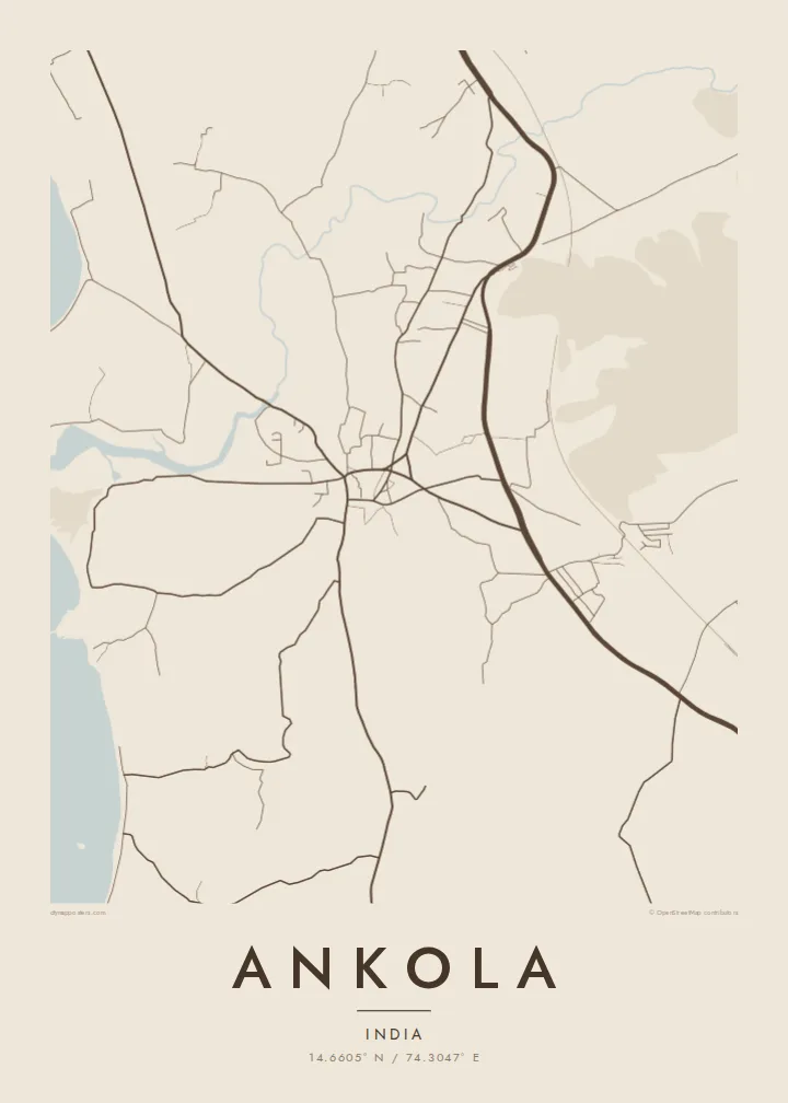
Ankola lies in Uttara Kannada district on the Karnataka coast, between Karwar to the north and Gokarna to the south. It sits on a narrow coastal plain, with beaches and the Arabian Sea to the west. To the east the land rises quickly into the forested slopes of the Western Ghats. On a map, the national highway and the Konkan Railway cross this strip in long parallel lines.
Ankola has a notable place in India's independence movement. During the salt satyagraha of 1930, people here made salt on the coast in defiance of colonial law. Today the town centre is a compact area of market streets. Houses spread out from it among coconut and areca plantations toward the shore and the nearby villages.
An Ankola map poster captures the layers of this coastline: sea, sand, settlement, road, rail and hills, each running roughly north to south. The Gangavali river reaches the sea just south of the town. Its curving line of water adds contrast to a composition otherwise shaped by the coast.
The Arabian Sea forms the western edge of the map, with the sandy shoreline curving past the town and the fishing settlements along it.
National Highway 66 and the Konkan Railway run through Ankola side by side, two long lines that trace the narrow coastal plain.
South of the town, the Gangavali river widens into its estuary before meeting the sea. This broad, curving shape anchors the lower part of the poster.
Taute ke ha hau
Lafi e aho, taha higoa po ke taha kupu haau, hiki e fakatino, lahi po ke tuaga.
Ko e kitiaaga nakai totogi kua tote e maaliali mo e fakamailoga vai. Ko e tau lolomi mo e tau faila HD kua taute ke he 300 DPI, hokotia ke he 7,200 × 10,800 px, nakai fai fakamailoga vai.
Ko e ha Ankola
An Ankola map is a meaningful gift for anyone from Uttara Kannada and a keepsake for travellers who have explored the quieter beaches of the Karnataka coast. Its long north-south lines give the composition a calm, orderly rhythm.
You can set your own title and subtitle, add a date and edit the coordinates line. Styles include Classic black & white, Noir, Paper, Blueprint and Sand. Download print-ready PDF and PNG files for $9, or order a matte poster shipped from a local print partner.
Talaage e poster Ankola| Lahi he lolomi | Maama | Tau faila |
|---|---|---|
| 30 × 40 cm11.8 × 15.7″ | 3,543 × 4,724 px | PNG · PDF |
| 29.7 × 42 cm (A3)11.7 × 16.5″ | 3,508 × 4,961 px | PNG · PDF |
| 42 × 59.4 cm (A2)16.5 × 23.4″ | 4,961 × 7,016 px | PNG · PDF |
| 45.7 × 61 cm18 × 24″ | 5,400 × 7,200 px | PNG · PDF |
| 50 × 70 cm19.7 × 27.6″ | 5,906 × 8,268 px | PNG · PDF |
| 61 × 91.4 cm24 × 36″ | 7,200 × 10,800 px | PNG · PDF |
Ke fakatatai, ko e fakatino noa kua 900 px e laulahi, fai fakamailoga mo e mo e tau mata komipiuta ni. Ko e tau faila HD kua ato hoko ke he 8× e maama ke he tau faahi takitaha mo e lolomi mitaki he lahi katoa he fakatino.
Fifili e taha puhala i luga he kupega, ti fifili e Poster Lolomi — e lahi mo e, kaeke ke manako ai koe, taha poloka — po ke Tau Faila HD Fakaeletonika. Ko e fakaotiaga totogi ko e taha gahua ni, ti ko e kupega he hau a talaaga ka fakafou fakahaga i mua he fakaotiaga e totogi.
Kua lolomi ai ke he pepa mitaki 200 gsm matte he taha he tau lahi ono, mai he 30 × 40 cm ke hoko ke he 24 × 36″. Kamata e tau poster lolomi mai he $39, kua putoia ai e utaaga.
E. Fifili e poloka akau malolō ke he lanu uli, tea, akau oki mooli, po ke akau pouli. Kua fakalataha mo e sioga malolō nakai malepe ti kua mautali ke tautau. Kamata e tau poster poloka mai he $99, kua putoia ai e utaaga.
Nakai totogi e fakafano ke he motu 60+. Ko e fakatino taha kua lolomi he fenoga lolomi ha mautolu kua tata mo e tau motu 30+, kua hoko mai he tau aho gahua 3–7. Maeke ia koe ke kikite e tuaga mo e fakamuitua he lalo he Haku Tau Fakatonu. Ke he falu motu kua 2–5 e tau tapu, ti ka nakai fakafano a mautolu ki ai, to fakaha he api tupe ia ki mua he totogi.
Fakafano mai e taha ata ki a mautolu he loto he 14 e tau aho tali mai he hokoaga, ti to lolomi foki e mautolu nakai totogi po ke liu atu e totogi ki a koe.
E. He editor i luga he kupega nei, hikihiki e matakupu, e matakupu lalo mo e laini coordinates ke he taha mena kua manako a koe ki ai, ti fifili e puhala mo e lahi. Ko e tau talaaga lolomi, poloka mo e fakaeletonika oti kua fakaaoga tonu e hau a fakatino.
Ma e $9 ka moua e koe e tau faila PNG 300 DPI mo e PDF kua mautali ke lolomi he tau lahi ono oti, nakai fai fakamailoga vai, ke lolomi i fe mena. Nakai maopoopo agaia? Utu hifo fakamua e kitiaaga nakai totogi ne fai fakamailoga vai.
