Twin bays
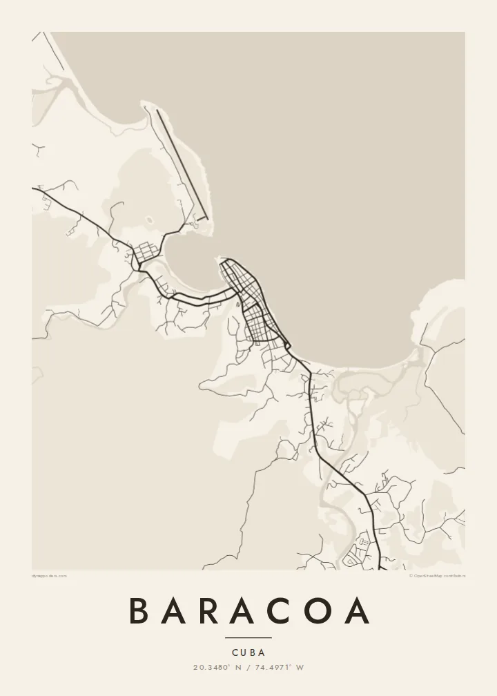
The town sits on a headland between two sheltered bays. Their curved shorelines give the northern and southern edges of the map a rounded shape that reads clearly even at small print sizes.
Fakatino mape mukamuka · Cuba
20.3480° N / 74.4971° W
A small bayside grid on Cuba's far eastern tip, held between a curving seafront, river mouths and a flat-topped mountain




Taha e taone, lima e onoonoaga
Tapaki e taha puhala ke kitia ai ki luga he puipui. Kua tatai e totogi he tau puhala oti — pete he lolomi, poloka, po ke faila HD.
 Tau pikselo mooli · faila lolomi 24 × 36″
Maama mitaki ke lolomi
Ko e 100% e fahi mooli mai he faila lolomi. Ko e tau poster oti — pete kua lolomi, poloka, po ke utu hifo — kua taute ke he ha mautolu a tau tokoluga (server) ke he 300 DPI, hokotia ke he 7,200 × 10,800 piksela, ke maeke ai e tau ala ikiiki tote ke maaliali fakamitaki he lolomi 24 × 36″.
He Pā


Ko e mape
Baracoa sits at the eastern end of Cuba, on a short stretch of coast where the land bends toward the Windward Passage. From above, the town is a compact block of streets on a low point between two bays. A seafront road follows the open shore to the north, and rivers come down from the forested hills behind to meet the sea on either side of the centre.
The town's place in history is simple to state. It was the first settlement the Spanish founded in Cuba, in 1511, and it served for a short time as the island's first capital. For centuries it could only be reached by sea. That changed in the 1960s with La Farola, the mountain road that climbs over the ranges from the south coast and appears on the map as a single thin winding line.
A Baracoa map poster shows how little room the town has between water and slope. The grid is dense and short. The bays give it a soft, rounded outline, and the countryside inland dissolves into thin lanes and river courses. Printed in black and white, the difference between the orderly centre and the loose, open land around it is the first thing you notice.
The town sits on a headland between two sheltered bays. Their curved shorelines give the northern and southern edges of the map a rounded shape that reads clearly even at small print sizes.
West of town rises El Yunque, a flat-topped mountain that sailors used as a landmark. On the map it shows up as open ground inland, with only a few tracks crossing it.
The mountain road that finally connected Baracoa to the rest of Cuba winds south through the hills. Where the street network ends, its switchbacks stand out as one looping line.
Taute ke ha hau
Lafi e aho, taha higoa po ke taha kupu haau, hiki e fakatino, lahi po ke tuaga.
Ko e kitiaaga nakai totogi kua tote e maaliali mo e fakamailoga vai. Ko e tau lolomi mo e tau faila HD kua taute ke he 300 DPI, hokotia ke he 7,200 × 10,800 px, nakai fai fakamailoga vai.
Ko e ha Baracoa
For many visitors, Baracoa is the part of Cuba that felt furthest from everything else: the end of a long road, a town facing the sea. A map of its few streets and two bays records that remoteness quietly, without needing a photograph.
You can set your own title, subtitle and coordinates line, which works well for a trip date or a family connection to Guantánamo Province. Choose Classic black & white, Noir, Paper, Blueprint or Sand. The file is $9 in HD, and printed posters ship from partners in more than 30 countries.
Talaage e poster Baracoa| Lahi he lolomi | Maama | Tau faila |
|---|---|---|
| 30 × 40 cm11.8 × 15.7″ | 3,543 × 4,724 px | PNG · PDF |
| 29.7 × 42 cm (A3)11.7 × 16.5″ | 3,508 × 4,961 px | PNG · PDF |
| 42 × 59.4 cm (A2)16.5 × 23.4″ | 4,961 × 7,016 px | PNG · PDF |
| 45.7 × 61 cm18 × 24″ | 5,400 × 7,200 px | PNG · PDF |
| 50 × 70 cm19.7 × 27.6″ | 5,906 × 8,268 px | PNG · PDF |
| 61 × 91.4 cm24 × 36″ | 7,200 × 10,800 px | PNG · PDF |
Ke fakatatai, ko e fakatino noa kua 900 px e laulahi, fai fakamailoga mo e mo e tau mata komipiuta ni. Ko e tau faila HD kua ato hoko ke he 8× e maama ke he tau faahi takitaha mo e lolomi mitaki he lahi katoa he fakatino.
Fifili e taha puhala i luga he kupega, ti fifili e Poster Lolomi — e lahi mo e, kaeke ke manako ai koe, taha poloka — po ke Tau Faila HD Fakaeletonika. Ko e fakaotiaga totogi ko e taha gahua ni, ti ko e kupega he hau a talaaga ka fakafou fakahaga i mua he fakaotiaga e totogi.
Kua lolomi ai ke he pepa mitaki 200 gsm matte he taha he tau lahi ono, mai he 30 × 40 cm ke hoko ke he 24 × 36″. Kamata e tau poster lolomi mai he $39, kua putoia ai e utaaga.
E. Fifili e poloka akau malolō ke he lanu uli, tea, akau oki mooli, po ke akau pouli. Kua fakalataha mo e sioga malolō nakai malepe ti kua mautali ke tautau. Kamata e tau poster poloka mai he $99, kua putoia ai e utaaga.
Nakai totogi e fakafano ke he motu 60+. Ko e fakatino taha kua lolomi he fenoga lolomi ha mautolu kua tata mo e tau motu 30+, kua hoko mai he tau aho gahua 3–7. Maeke ia koe ke kikite e tuaga mo e fakamuitua he lalo he Haku Tau Fakatonu. Ke he falu motu kua 2–5 e tau tapu, ti ka nakai fakafano a mautolu ki ai, to fakaha he api tupe ia ki mua he totogi.
Fakafano mai e taha ata ki a mautolu he loto he 14 e tau aho tali mai he hokoaga, ti to lolomi foki e mautolu nakai totogi po ke liu atu e totogi ki a koe.
E. He editor i luga he kupega nei, hikihiki e matakupu, e matakupu lalo mo e laini coordinates ke he taha mena kua manako a koe ki ai, ti fifili e puhala mo e lahi. Ko e tau talaaga lolomi, poloka mo e fakaeletonika oti kua fakaaoga tonu e hau a fakatino.
Ma e $9 ka moua e koe e tau faila PNG 300 DPI mo e PDF kua mautali ke lolomi he tau lahi ono oti, nakai fai fakamailoga vai, ke lolomi i fe mena. Nakai maopoopo agaia? Utu hifo fakamua e kitiaaga nakai totogi ne fai fakamailoga vai.
