Tidal channels
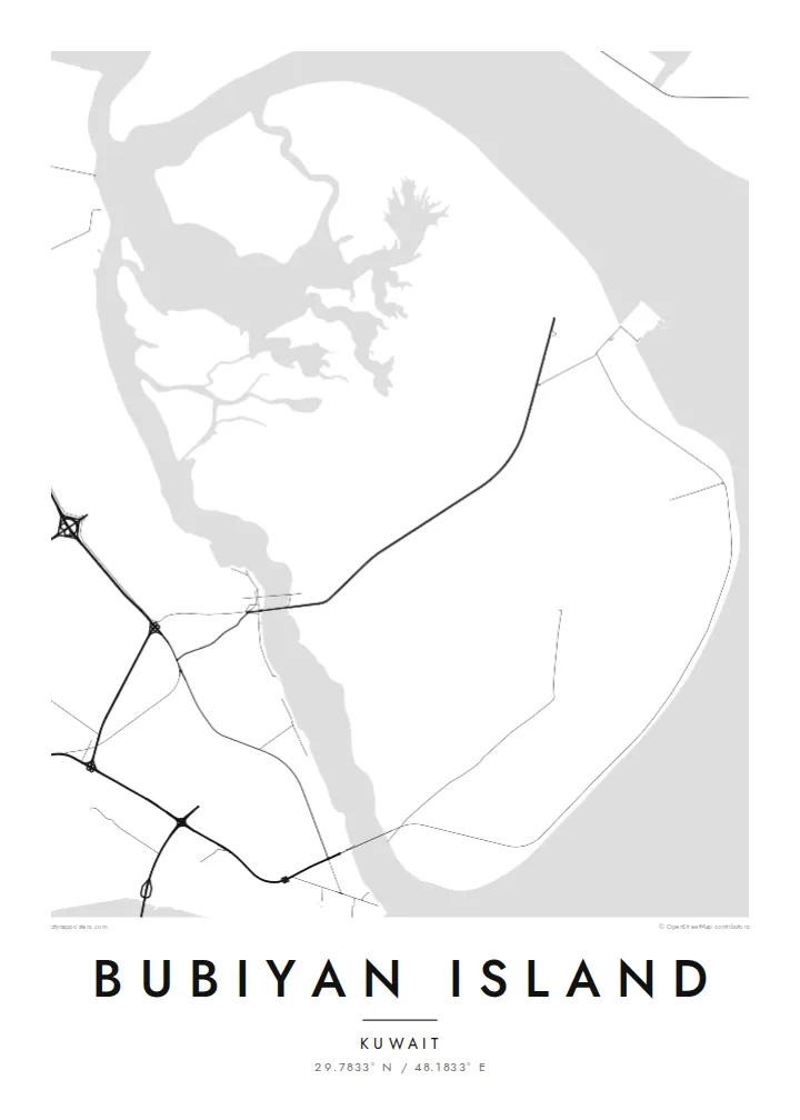
Winding creeks cut across the island's edges and into its marshes, drawing branching, river-like patterns that give the flat ground its only real texture.
Fakatino mape mukamuka · Kuwait
29.7833° N / 48.1833° E
A flat, low-lying island of mudflats and marsh at the head of the Gulf, edged by winding tidal channels.
Taha e taone, lima e onoonoaga
Tapaki e taha puhala ke kitia ai ki luga he puipui. Kua tatai e totogi he tau puhala oti — pete he lolomi, poloka, po ke faila HD.
 Tau pikselo mooli · faila lolomi 24 × 36″
Maama mitaki ke lolomi
Ko e 100% e fahi mooli mai he faila lolomi. Ko e tau poster oti — pete kua lolomi, poloka, po ke utu hifo — kua taute ke he ha mautolu a tau tokoluga (server) ke he 300 DPI, hokotia ke he 7,200 × 10,800 piksela, ke maeke ai e tau ala ikiiki tote ke maaliali fakamitaki he lolomi 24 × 36″.
He Pā


Ko e mape
Bubiyan is the largest island in Kuwait, lying at the northern end of the Gulf near the mouth of the Shatt al-Arab. It is almost perfectly flat, much of it salt marsh and tidal mudflat, and its edges blur into channels and shoals rather than forming a crisp coast. On a map the island reads as a broad, low shape laced with meandering creeks.
Khor Abdullah runs along its eastern side toward Iraq, while a narrow channel divides it from the Kuwaiti mainland, crossed by a bridge. The island has no towns. Large parts are protected for wildlife, and its mudflats are an important site for wading birds, including the crab plover. Recent development has centred on a large port project on its eastern coast.
A Bubiyan Island map poster is an exercise in subtle lines: branching tidal channels, faint tracks and the straight mark of the bridge crossing from the mainland. There is little in the way of streets, and that absence gives the design an almost abstract quality. It suits people with ties to Kuwait who want something quieter than a city plan.
Winding creeks cut across the island's edges and into its marshes, drawing branching, river-like patterns that give the flat ground its only real texture.
A bridge carries the road across the narrow channel from the Kuwaiti mainland, a single straight line tying the island to the coast opposite.
The waterway along the island's eastern side leads toward Iraq's ports and frames Bubiyan against the wider head of the Gulf.
Taute ke ha hau
Lafi e aho, taha higoa po ke taha kupu haau, hiki e fakatino, lahi po ke tuaga.
Ko e kitiaaga nakai totogi kua tote e maaliali mo e fakamailoga vai. Ko e tau lolomi mo e tau faila HD kua taute ke he 300 DPI, hokotia ke he 7,200 × 10,800 px, nakai fai fakamailoga vai.
Ko e ha Bubiyan Island
Bubiyan appeals to Kuwaitis and to people who have lived in the country, as well as to birdwatchers who know it for its wading birds. Its soft, low outline makes a restful, almost abstract piece for a study or office.
Personalise the title, subtitle and coordinates line with a family name or a meaningful date. Choose Classic black & white, Noir, Paper, Blueprint or Sand; the lighter styles bring out the fine channels, while Noir turns the island into a bold silhouette.
Talaage e poster Bubiyan Island| Lahi he lolomi | Maama | Tau faila |
|---|---|---|
| 30 × 40 cm11.8 × 15.7″ | 3,543 × 4,724 px | PNG · PDF |
| 29.7 × 42 cm (A3)11.7 × 16.5″ | 3,508 × 4,961 px | PNG · PDF |
| 42 × 59.4 cm (A2)16.5 × 23.4″ | 4,961 × 7,016 px | PNG · PDF |
| 45.7 × 61 cm18 × 24″ | 5,400 × 7,200 px | PNG · PDF |
| 50 × 70 cm19.7 × 27.6″ | 5,906 × 8,268 px | PNG · PDF |
| 61 × 91.4 cm24 × 36″ | 7,200 × 10,800 px | PNG · PDF |
Ke fakatatai, ko e fakatino noa kua 900 px e laulahi, fai fakamailoga mo e mo e tau mata komipiuta ni. Ko e tau faila HD kua ato hoko ke he 8× e maama ke he tau faahi takitaha mo e lolomi mitaki he lahi katoa he fakatino.
Fifili e taha puhala i luga he kupega, ti fifili e Poster Lolomi — e lahi mo e, kaeke ke manako ai koe, taha poloka — po ke Tau Faila HD Fakaeletonika. Ko e fakaotiaga totogi ko e taha gahua ni, ti ko e kupega he hau a talaaga ka fakafou fakahaga i mua he fakaotiaga e totogi.
Kua lolomi ai ke he pepa mitaki 200 gsm matte he taha he tau lahi ono, mai he 30 × 40 cm ke hoko ke he 24 × 36″. Kamata e tau poster lolomi mai he $39, kua putoia ai e utaaga.
E. Fifili e poloka akau malolō ke he lanu uli, tea, akau oki mooli, po ke akau pouli. Kua fakalataha mo e sioga malolō nakai malepe ti kua mautali ke tautau. Kamata e tau poster poloka mai he $99, kua putoia ai e utaaga.
Nakai totogi e fakafano ke he motu 60+. Ko e fakatino taha kua lolomi he fenoga lolomi ha mautolu kua tata mo e tau motu 30+, kua hoko mai he tau aho gahua 3–7. Maeke ia koe ke kikite e tuaga mo e fakamuitua he lalo he Haku Tau Fakatonu. Ke he falu motu kua 2–5 e tau tapu, ti ka nakai fakafano a mautolu ki ai, to fakaha he api tupe ia ki mua he totogi.
Fakafano mai e taha ata ki a mautolu he loto he 14 e tau aho tali mai he hokoaga, ti to lolomi foki e mautolu nakai totogi po ke liu atu e totogi ki a koe.
E. He editor i luga he kupega nei, hikihiki e matakupu, e matakupu lalo mo e laini coordinates ke he taha mena kua manako a koe ki ai, ti fifili e puhala mo e lahi. Ko e tau talaaga lolomi, poloka mo e fakaeletonika oti kua fakaaoga tonu e hau a fakatino.
Ma e $9 ka moua e koe e tau faila PNG 300 DPI mo e PDF kua mautali ke lolomi he tau lahi ono oti, nakai fai fakamailoga vai, ke lolomi i fe mena. Nakai maopoopo agaia? Utu hifo fakamua e kitiaaga nakai totogi ne fai fakamailoga vai.
Tata mai
