Atlantic Avenue
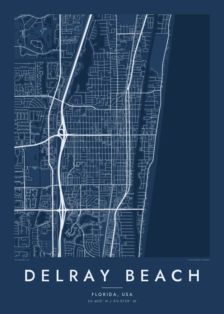
The town's main street runs from the ocean across the Intracoastal and into the downtown grid, a straight line that ties the whole composition together.
Fakatino mape mukamuka · United States
26.4615° N / 80.0728° W
A South Florida town laid out on a grid between the Atlantic beach, the Intracoastal Waterway and the lakes further west.



Taha e taone, lima e onoonoaga
Tapaki e taha puhala ke kitia ai ki luga he puipui. Kua tatai e totogi he tau puhala oti — pete he lolomi, poloka, po ke faila HD.
 Tau pikselo mooli · faila lolomi 24 × 36″
Maama mitaki ke lolomi
Ko e 100% e fahi mooli mai he faila lolomi. Ko e tau poster oti — pete kua lolomi, poloka, po ke utu hifo — kua taute ke he ha mautolu a tau tokoluga (server) ke he 300 DPI, hokotia ke he 7,200 × 10,800 piksela, ke maeke ai e tau ala ikiiki tote ke maaliali fakamitaki he lolomi 24 × 36″.
He Pā


Ko e mape
Delray Beach occupies a strip of south-eastern Florida between the Atlantic Ocean and the flat land inland. Its map is organised in bands: a narrow barrier island with the beach and the ocean road, the Intracoastal Waterway running parallel just behind it, and then the mainland grid extending west toward the suburbs.
Atlantic Avenue is the town's main axis. It runs east to west from the beach, across the waterway and through downtown, where shops, restaurants and galleries line the street. The blocks around it form a regular grid, crossed by railway lines running north to south, a pattern typical of Florida's older coastal towns.
Further west the plan shifts to curving developments, golf courses and lakes. There the Morikami Museum and Japanese Gardens recall the Yamato Colony, a community of Japanese farmers who settled in the area in the early twentieth century. A Delray Beach map poster shows the full range, from the straight ocean edge to the soft shapes of the western neighbourhoods.
The town's main street runs from the ocean across the Intracoastal and into the downtown grid, a straight line that ties the whole composition together.
The waterway runs north to south behind the barrier island, its narrow channel and small inlets forming a clean line of water parallel to the coast.
Inland neighbourhoods are shaped around artificial lakes and golf courses, giving the western part of the map rounded forms that contrast with the coastal grid.
Taute ke ha hau
Lafi e aho, taha higoa po ke taha kupu haau, hiki e fakatino, lahi po ke tuaga.
Ko e kitiaaga nakai totogi kua tote e maaliali mo e fakamailoga vai. Ko e tau lolomi mo e tau faila HD kua taute ke he 300 DPI, hokotia ke he 7,200 × 10,800 px, nakai fai fakamailoga vai.
Ko e ha Delray Beach
Delray Beach is where many people spend winters, holidays or their retirement, and a map of it brings back the walk down Atlantic Avenue to the sea. It works as a gift for someone who has just moved there or who left after many years.
Set the title to the town name or a street, write a date in the subtitle and adjust the coordinates. Blueprint and Sand suit the coastal setting, Classic black & white and Noir give the grid a sharp graphic look, and Paper is softer.
Talaage e poster Delray Beach| Lahi he lolomi | Maama | Tau faila |
|---|---|---|
| 30 × 40 cm11.8 × 15.7″ | 3,543 × 4,724 px | PNG · PDF |
| 29.7 × 42 cm (A3)11.7 × 16.5″ | 3,508 × 4,961 px | PNG · PDF |
| 42 × 59.4 cm (A2)16.5 × 23.4″ | 4,961 × 7,016 px | PNG · PDF |
| 45.7 × 61 cm18 × 24″ | 5,400 × 7,200 px | PNG · PDF |
| 50 × 70 cm19.7 × 27.6″ | 5,906 × 8,268 px | PNG · PDF |
| 61 × 91.4 cm24 × 36″ | 7,200 × 10,800 px | PNG · PDF |
Ke fakatatai, ko e fakatino noa kua 900 px e laulahi, fai fakamailoga mo e mo e tau mata komipiuta ni. Ko e tau faila HD kua ato hoko ke he 8× e maama ke he tau faahi takitaha mo e lolomi mitaki he lahi katoa he fakatino.
Fifili e taha puhala i luga he kupega, ti fifili e Poster Lolomi — e lahi mo e, kaeke ke manako ai koe, taha poloka — po ke Tau Faila HD Fakaeletonika. Ko e fakaotiaga totogi ko e taha gahua ni, ti ko e kupega he hau a talaaga ka fakafou fakahaga i mua he fakaotiaga e totogi.
Kua lolomi ai ke he pepa mitaki 200 gsm matte he taha he tau lahi ono, mai he 30 × 40 cm ke hoko ke he 24 × 36″. Kamata e tau poster lolomi mai he $39, kua putoia ai e utaaga.
E. Fifili e poloka akau malolō ke he lanu uli, tea, akau oki mooli, po ke akau pouli. Kua fakalataha mo e sioga malolō nakai malepe ti kua mautali ke tautau. Kamata e tau poster poloka mai he $99, kua putoia ai e utaaga.
Nakai totogi e fakafano ke he motu 60+. Ko e fakatino taha kua lolomi he fenoga lolomi ha mautolu kua tata mo e tau motu 30+, kua hoko mai he tau aho gahua 3–7. Maeke ia koe ke kikite e tuaga mo e fakamuitua he lalo he Haku Tau Fakatonu. Ke he falu motu kua 2–5 e tau tapu, ti ka nakai fakafano a mautolu ki ai, to fakaha he api tupe ia ki mua he totogi.
Fakafano mai e taha ata ki a mautolu he loto he 14 e tau aho tali mai he hokoaga, ti to lolomi foki e mautolu nakai totogi po ke liu atu e totogi ki a koe.
E. He editor i luga he kupega nei, hikihiki e matakupu, e matakupu lalo mo e laini coordinates ke he taha mena kua manako a koe ki ai, ti fifili e puhala mo e lahi. Ko e tau talaaga lolomi, poloka mo e fakaeletonika oti kua fakaaoga tonu e hau a fakatino.
Ma e $9 ka moua e koe e tau faila PNG 300 DPI mo e PDF kua mautali ke lolomi he tau lahi ono oti, nakai fai fakamailoga vai, ke lolomi i fe mena. Nakai maopoopo agaia? Utu hifo fakamua e kitiaaga nakai totogi ne fai fakamailoga vai.
Tata mai
