Great Belt link
The fixed link to Zealand leaves Funen's east coast near Nyborg and crosses the strait by way of the small island of Sprogø. On the map it is a long, straight line across open water.
Fakatino mape mukamuka · Denmark
55.3367° N / 10.2666° E
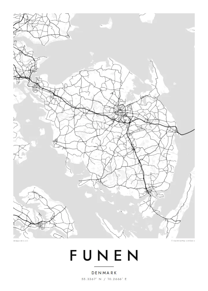
A broad, rounded Danish island between two straits, with Odense near its centre and an archipelago scattered off its southern coast


Taha e taone, lima e onoonoaga
Tapaki e taha puhala ke kitia ai ki luga he puipui. Kua tatai e totogi he tau puhala oti — pete he lolomi, poloka, po ke faila HD.
 Tau pikselo mooli · faila lolomi 24 × 36″
Maama mitaki ke lolomi
Ko e 100% e fahi mooli mai he faila lolomi. Ko e tau poster oti — pete kua lolomi, poloka, po ke utu hifo — kua taute ke he ha mautolu a tau tokoluga (server) ke he 300 DPI, hokotia ke he 7,200 × 10,800 piksela, ke maeke ai e tau ala ikiiki tote ke maaliali fakamitaki he lolomi 24 × 36″.
He Pā


Ko e mape
Funen lies between Jutland and Zealand, and on a map it sits squarely in the middle of Denmark, with the Little Belt to the west and the Great Belt to the east. The island is broad and compact. Country roads cross gently rolling farmland, small towns are spaced evenly across the land, and the coastline is cut by shallow fjords and bays.
Odense, the island's largest city and one of the oldest in Denmark, sits near the centre. Ring roads surround its historic core, and a canal leads north to Odense Fjord. The city is the birthplace of Hans Christian Andersen. Bridges carry road and rail west to Jutland, and the long Great Belt link runs east toward Zealand.
South of the island lies the South Funen Archipelago, with Tåsinge, Ærø and many smaller islands reached by bridge and ferry. Castles and manor estates are scattered across the countryside, among them Egeskov with its moat. A Funen map poster shows the island as a hub: the city at the centre, bridges on either side and islands trailing off to the south.
The fixed link to Zealand leaves Funen's east coast near Nyborg and crosses the strait by way of the small island of Sprogø. On the map it is a long, straight line across open water.
At the heart of the island, ring roads enclose Odense's old centre. The river Odense Å winds through it and through parks, and a canal carries on north to the fjord.
Off the south coast, a scatter of islands and islets breaks up the water around Svendborg Sound. It turns the bottom of the map into a mosaic of small coastlines.
Taute ke ha hau
Lafi e aho, taha higoa po ke taha kupu haau, hiki e fakatino, lahi po ke tuaga.
Ko e kitiaaga nakai totogi kua tote e maaliali mo e fakamailoga vai. Ko e tau lolomi mo e tau faila HD kua taute ke he 300 DPI, hokotia ke he 7,200 × 10,800 px, nakai fai fakamailoga vai.
Ko e ha Funen
This is a map for people from Odense, Svendborg or the small towns in between, and for anyone who thinks of Funen as the green middle of Denmark. The rounded shape, the bridges and the southern islands give the print a pleasing balance.
You can personalise the title, subtitle and coordinates, add a date that matters to you, and choose one of five styles. The $9 digital files cover six sizes, including 50×70 cm and A2, each as a 300 DPI PNG and a print-ready PDF.
Talaage e poster Funen| Lahi he lolomi | Maama | Tau faila |
|---|---|---|
| 30 × 40 cm11.8 × 15.7″ | 3,543 × 4,724 px | PNG · PDF |
| 29.7 × 42 cm (A3)11.7 × 16.5″ | 3,508 × 4,961 px | PNG · PDF |
| 42 × 59.4 cm (A2)16.5 × 23.4″ | 4,961 × 7,016 px | PNG · PDF |
| 45.7 × 61 cm18 × 24″ | 5,400 × 7,200 px | PNG · PDF |
| 50 × 70 cm19.7 × 27.6″ | 5,906 × 8,268 px | PNG · PDF |
| 61 × 91.4 cm24 × 36″ | 7,200 × 10,800 px | PNG · PDF |
Ke fakatatai, ko e fakatino noa kua 900 px e laulahi, fai fakamailoga mo e mo e tau mata komipiuta ni. Ko e tau faila HD kua ato hoko ke he 8× e maama ke he tau faahi takitaha mo e lolomi mitaki he lahi katoa he fakatino.
Fifili e taha puhala i luga he kupega, ti fifili e Poster Lolomi — e lahi mo e, kaeke ke manako ai koe, taha poloka — po ke Tau Faila HD Fakaeletonika. Ko e fakaotiaga totogi ko e taha gahua ni, ti ko e kupega he hau a talaaga ka fakafou fakahaga i mua he fakaotiaga e totogi.
Kua lolomi ai ke he pepa mitaki 200 gsm matte he taha he tau lahi ono, mai he 30 × 40 cm ke hoko ke he 24 × 36″. Kamata e tau poster lolomi mai he $39, kua putoia ai e utaaga.
E. Fifili e poloka akau malolō ke he lanu uli, tea, akau oki mooli, po ke akau pouli. Kua fakalataha mo e sioga malolō nakai malepe ti kua mautali ke tautau. Kamata e tau poster poloka mai he $99, kua putoia ai e utaaga.
Nakai totogi e fakafano ke he motu 60+. Ko e fakatino taha kua lolomi he fenoga lolomi ha mautolu kua tata mo e tau motu 30+, kua hoko mai he tau aho gahua 3–7. Maeke ia koe ke kikite e tuaga mo e fakamuitua he lalo he Haku Tau Fakatonu. Ke he falu motu kua 2–5 e tau tapu, ti ka nakai fakafano a mautolu ki ai, to fakaha he api tupe ia ki mua he totogi.
Fakafano mai e taha ata ki a mautolu he loto he 14 e tau aho tali mai he hokoaga, ti to lolomi foki e mautolu nakai totogi po ke liu atu e totogi ki a koe.
E. He editor i luga he kupega nei, hikihiki e matakupu, e matakupu lalo mo e laini coordinates ke he taha mena kua manako a koe ki ai, ti fifili e puhala mo e lahi. Ko e tau talaaga lolomi, poloka mo e fakaeletonika oti kua fakaaoga tonu e hau a fakatino.
Ma e $9 ka moua e koe e tau faila PNG 300 DPI mo e PDF kua mautali ke lolomi he tau lahi ono oti, nakai fai fakamailoga vai, ke lolomi i fe mena. Nakai maopoopo agaia? Utu hifo fakamua e kitiaaga nakai totogi ne fai fakamailoga vai.
Tata mai
