Mikuma River
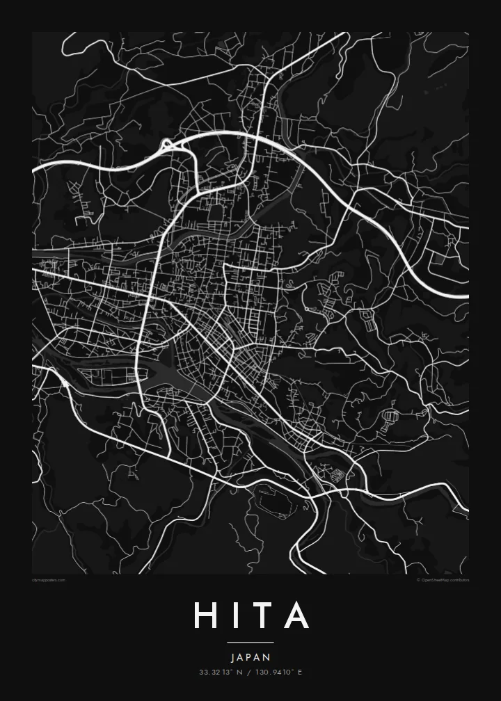
The Mikuma River curves through the heart of the basin, gathering smaller tributaries and dividing the town into districts, the strongest line on the entire map.
Fakatino mape mukamuka · Japan
33.3213° N / 130.9410° E
A mountain basin town gathered around the Mikuma River, its Edo-era merchant streets set among forested Kyushu hills.



Taha e taone, lima e onoonoaga
Tapaki e taha puhala ke kitia ai ki luga he puipui. Kua tatai e totogi he tau puhala oti — pete he lolomi, poloka, po ke faila HD.
 Tau pikselo mooli · faila lolomi 24 × 36″
Maama mitaki ke lolomi
Ko e 100% e fahi mooli mai he faila lolomi. Ko e tau poster oti — pete kua lolomi, poloka, po ke utu hifo — kua taute ke he ha mautolu a tau tokoluga (server) ke he 300 DPI, hokotia ke he 7,200 × 10,800 piksela, ke maeke ai e tau ala ikiiki tote ke maaliali fakamitaki he lolomi 24 × 36″.
He Pā


Ko e mape
Hita occupies a basin in the west of Oita Prefecture, enclosed by forested mountains on every side. Several rivers flow into the basin and join to form the Mikuma River, which runs through the town before continuing toward the Ariake Sea as the Chikugo River. On the map the rivers are the main event, bending through the urban area and dividing it into a series of distinct districts.
During the Edo period Hita was a directly governed territory of the Tokugawa shogunate, and its merchants grew prosperous. The Mamedamachi district preserves their streets, a compact grid of old warehouses and shops that appears on the poster as a finely drawn cluster. Nearby stood Kangien, the private academy founded by the scholar Hirose Tansō, which drew students from across Japan.
Along the Mikuma River, hot spring inns line the banks, and in summer the river is known for traditional cormorant fishing from wooden boats. Around the town, cedar forests cover the slopes that close in the basin. A Hita map poster places the old town, the river and the mountains in a single, balanced frame.
The Mikuma River curves through the heart of the basin, gathering smaller tributaries and dividing the town into districts, the strongest line on the entire map.
The preserved merchant district of Mamedamachi forms a small, dense grid of historic streets, a finely detailed cluster that recalls Hita's Edo-period wealth.
Forested slopes rise on all sides of the basin, and the roads that climb out of town follow the valleys in long winding lines toward the edges.
Taute ke ha hau
Lafi e aho, taha higoa po ke taha kupu haau, hiki e fakatino, lahi po ke tuaga.
Ko e kitiaaga nakai totogi kua tote e maaliali mo e fakamailoga vai. Ko e tau lolomi mo e tau faila HD kua taute ke he 300 DPI, hokotia ke he 7,200 × 10,800 px, nakai fai fakamailoga vai.
Ko e ha Hita
Hita rewards a close look, much like its old streets reward a slow walk, and a map of the town suits anyone who has stayed by the river or grown up among its hills. The basin shape makes a naturally framed composition.
Paper and Sand bring out the warmth of the old town, while Noir and Blueprint give the rivers a sharper edge, and Classic black & white keeps it simple. Personalise the title, subtitle and coordinates, then download six print sizes for $9.
Talaage e poster Hita| Lahi he lolomi | Maama | Tau faila |
|---|---|---|
| 30 × 40 cm11.8 × 15.7″ | 3,543 × 4,724 px | PNG · PDF |
| 29.7 × 42 cm (A3)11.7 × 16.5″ | 3,508 × 4,961 px | PNG · PDF |
| 42 × 59.4 cm (A2)16.5 × 23.4″ | 4,961 × 7,016 px | PNG · PDF |
| 45.7 × 61 cm18 × 24″ | 5,400 × 7,200 px | PNG · PDF |
| 50 × 70 cm19.7 × 27.6″ | 5,906 × 8,268 px | PNG · PDF |
| 61 × 91.4 cm24 × 36″ | 7,200 × 10,800 px | PNG · PDF |
Ke fakatatai, ko e fakatino noa kua 900 px e laulahi, fai fakamailoga mo e mo e tau mata komipiuta ni. Ko e tau faila HD kua ato hoko ke he 8× e maama ke he tau faahi takitaha mo e lolomi mitaki he lahi katoa he fakatino.
Fifili e taha puhala i luga he kupega, ti fifili e Poster Lolomi — e lahi mo e, kaeke ke manako ai koe, taha poloka — po ke Tau Faila HD Fakaeletonika. Ko e fakaotiaga totogi ko e taha gahua ni, ti ko e kupega he hau a talaaga ka fakafou fakahaga i mua he fakaotiaga e totogi.
Kua lolomi ai ke he pepa mitaki 200 gsm matte he taha he tau lahi ono, mai he 30 × 40 cm ke hoko ke he 24 × 36″. Kamata e tau poster lolomi mai he $39, kua putoia ai e utaaga.
E. Fifili e poloka akau malolō ke he lanu uli, tea, akau oki mooli, po ke akau pouli. Kua fakalataha mo e sioga malolō nakai malepe ti kua mautali ke tautau. Kamata e tau poster poloka mai he $99, kua putoia ai e utaaga.
Nakai totogi e fakafano ke he motu 60+. Ko e fakatino taha kua lolomi he fenoga lolomi ha mautolu kua tata mo e tau motu 30+, kua hoko mai he tau aho gahua 3–7. Maeke ia koe ke kikite e tuaga mo e fakamuitua he lalo he Haku Tau Fakatonu. Ke he falu motu kua 2–5 e tau tapu, ti ka nakai fakafano a mautolu ki ai, to fakaha he api tupe ia ki mua he totogi.
Fakafano mai e taha ata ki a mautolu he loto he 14 e tau aho tali mai he hokoaga, ti to lolomi foki e mautolu nakai totogi po ke liu atu e totogi ki a koe.
E. He editor i luga he kupega nei, hikihiki e matakupu, e matakupu lalo mo e laini coordinates ke he taha mena kua manako a koe ki ai, ti fifili e puhala mo e lahi. Ko e tau talaaga lolomi, poloka mo e fakaeletonika oti kua fakaaoga tonu e hau a fakatino.
Ma e $9 ka moua e koe e tau faila PNG 300 DPI mo e PDF kua mautali ke lolomi he tau lahi ono oti, nakai fai fakamailoga vai, ke lolomi i fe mena. Nakai maopoopo agaia? Utu hifo fakamua e kitiaaga nakai totogi ne fai fakamailoga vai.
Tata mai
