Euphrates riverfront
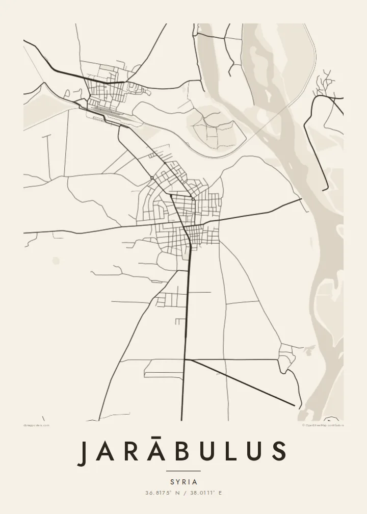
The Euphrates runs broad along the eastern side of the town, its banks lined with fields and floodplain. On the poster, the river gives the whole composition its weight and direction.
Fakatino mape mukamuka · Syria
36.8175° N / 38.0111° E
A town on the west bank of the Euphrates at the Turkish border, beside the ancient mound of Carchemish




Taha e taone, lima e onoonoaga
Tapaki e taha puhala ke kitia ai ki luga he puipui. Kua tatai e totogi he tau puhala oti — pete he lolomi, poloka, po ke faila HD.
 Tau pikselo mooli · faila lolomi 24 × 36″
Maama mitaki ke lolomi
Ko e 100% e fahi mooli mai he faila lolomi. Ko e tau poster oti — pete kua lolomi, poloka, po ke utu hifo — kua taute ke he ha mautolu a tau tokoluga (server) ke he 300 DPI, hokotia ke he 7,200 × 10,800 piksela, ke maeke ai e tau ala ikiiki tote ke maaliali fakamitaki he lolomi 24 × 36″.
He Pā


Ko e mape
Jarābulus stands on the western bank of the Euphrates in northern Syria, directly on the border with Turkey. On the map, the river dominates: a wide band running north to south along the town's eastern edge. The border meets the water just north of the built-up area, so the town sits in a corner formed by a river and a frontier.
Just north of the town lies Carchemish, one of the major cities of the ancient Near East, whose ruins straddle the border. Before the First World War, Leonard Woolley led excavations there, and a young T. E. Lawrence was on the team. Nearby, the historic Baghdad Railway crosses the Euphrates on a long bridge, a clear straight stroke on any map of the area.
The town itself is compact. Its streets sit back from the riverbank, and roads lead south and west into the farmland of the Aleppo countryside. A Jarābulus map poster reduces all of this to a few essential lines: river, rail, border and town. It is a small place whose position has made it significant for thousands of years.
The Euphrates runs broad along the eastern side of the town, its banks lined with fields and floodplain. On the poster, the river gives the whole composition its weight and direction.
The ancient city lies just north of the modern streets, on the river near the border. It is one of the oldest urban sites in the region.
The historic Baghdad Railway crosses the Euphrates near the town on a long bridge. Its straight line across the water is one of the clearest features of the local map.
Taute ke ha hau
Lafi e aho, taha higoa po ke taha kupu haau, hiki e fakatino, lahi po ke tuaga.
Ko e kitiaaga nakai totogi kua tote e maaliali mo e fakamailoga vai. Ko e tau lolomi mo e tau faila HD kua taute ke he 300 DPI, hokotia ke he 7,200 × 10,800 px, nakai fai fakamailoga vai.
Ko e ha Jarābulus
For people from Jarābulus, including the many who now live elsewhere, a map of the town holds on to a specific place by the river. It also suits anyone drawn to the archaeology of Carchemish or the long history of the upper Euphrates.
Add a title in your own words, a subtitle, a date and the coordinates line, and pick Classic black & white, Noir, Paper, Blueprint or Sand. The $9 digital files cover six sizes from 30×40 cm to 24×36″, each as a 300 DPI PNG and a print-ready PDF.
Talaage e poster Jarābulus| Lahi he lolomi | Maama | Tau faila |
|---|---|---|
| 30 × 40 cm11.8 × 15.7″ | 3,543 × 4,724 px | PNG · PDF |
| 29.7 × 42 cm (A3)11.7 × 16.5″ | 3,508 × 4,961 px | PNG · PDF |
| 42 × 59.4 cm (A2)16.5 × 23.4″ | 4,961 × 7,016 px | PNG · PDF |
| 45.7 × 61 cm18 × 24″ | 5,400 × 7,200 px | PNG · PDF |
| 50 × 70 cm19.7 × 27.6″ | 5,906 × 8,268 px | PNG · PDF |
| 61 × 91.4 cm24 × 36″ | 7,200 × 10,800 px | PNG · PDF |
Ke fakatatai, ko e fakatino noa kua 900 px e laulahi, fai fakamailoga mo e mo e tau mata komipiuta ni. Ko e tau faila HD kua ato hoko ke he 8× e maama ke he tau faahi takitaha mo e lolomi mitaki he lahi katoa he fakatino.
Fifili e taha puhala i luga he kupega, ti fifili e Poster Lolomi — e lahi mo e, kaeke ke manako ai koe, taha poloka — po ke Tau Faila HD Fakaeletonika. Ko e fakaotiaga totogi ko e taha gahua ni, ti ko e kupega he hau a talaaga ka fakafou fakahaga i mua he fakaotiaga e totogi.
Kua lolomi ai ke he pepa mitaki 200 gsm matte he taha he tau lahi ono, mai he 30 × 40 cm ke hoko ke he 24 × 36″. Kamata e tau poster lolomi mai he $39, kua putoia ai e utaaga.
E. Fifili e poloka akau malolō ke he lanu uli, tea, akau oki mooli, po ke akau pouli. Kua fakalataha mo e sioga malolō nakai malepe ti kua mautali ke tautau. Kamata e tau poster poloka mai he $99, kua putoia ai e utaaga.
Nakai totogi e fakafano ke he motu 60+. Ko e fakatino taha kua lolomi he fenoga lolomi ha mautolu kua tata mo e tau motu 30+, kua hoko mai he tau aho gahua 3–7. Maeke ia koe ke kikite e tuaga mo e fakamuitua he lalo he Haku Tau Fakatonu. Ke he falu motu kua 2–5 e tau tapu, ti ka nakai fakafano a mautolu ki ai, to fakaha he api tupe ia ki mua he totogi.
Fakafano mai e taha ata ki a mautolu he loto he 14 e tau aho tali mai he hokoaga, ti to lolomi foki e mautolu nakai totogi po ke liu atu e totogi ki a koe.
E. He editor i luga he kupega nei, hikihiki e matakupu, e matakupu lalo mo e laini coordinates ke he taha mena kua manako a koe ki ai, ti fifili e puhala mo e lahi. Ko e tau talaaga lolomi, poloka mo e fakaeletonika oti kua fakaaoga tonu e hau a fakatino.
Ma e $9 ka moua e koe e tau faila PNG 300 DPI mo e PDF kua mautali ke lolomi he tau lahi ono oti, nakai fai fakamailoga vai, ke lolomi i fe mena. Nakai maopoopo agaia? Utu hifo fakamua e kitiaaga nakai totogi ne fai fakamailoga vai.
Tata mai
