The national road
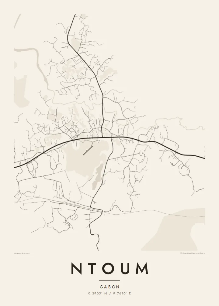
The main highway heading east from Libreville forms the backbone of the map. Nearly every other street connects back to it, so the line of the road organises the whole composition.
Fakatino mape mukamuka · Gabon
0.3905° N / 9.7610° E
A roadside town east of Libreville, its streets strung along the national road and pressed in by equatorial forest




Taha e taone, lima e onoonoaga
Tapaki e taha puhala ke kitia ai ki luga he puipui. Kua tatai e totogi he tau puhala oti — pete he lolomi, poloka, po ke faila HD.
 Tau pikselo mooli · faila lolomi 24 × 36″
Maama mitaki ke lolomi
Ko e 100% e fahi mooli mai he faila lolomi. Ko e tau poster oti — pete kua lolomi, poloka, po ke utu hifo — kua taute ke he ha mautolu a tau tokoluga (server) ke he 300 DPI, hokotia ke he 7,200 × 10,800 piksela, ke maeke ai e tau ala ikiiki tote ke maaliali fakamitaki he lolomi 24 × 36″.
He Pā


Ko e mape
Ntoum sits in Gabon's Estuaire province, a short drive east of Libreville and only a few dozen kilometres north of the equator. On a map it reads as a settlement shaped by a road: the main national route runs through it, and the town has grown along that line rather than around a single centre, with side streets branching off into cleared ground and then stopping where the forest resumes.
That relationship between built area and green mass is what gives the drawing its character. Roads thin out quickly, tracks wander toward small streams, and the blocks near the main route are denser than anywhere else. Printed in black and white, the town becomes a spine with ribs, a clear record of how a commuter settlement forms at the edge of a capital region.
A Ntoum map poster suits someone with a personal link to the place, whether they grew up there, work on the Libreville side of the estuary or passed through on the way inland. The composition is quiet and linear, with plenty of open space around the street network, which keeps the print calm on a wall and lets the title and coordinates carry the story.
The main highway heading east from Libreville forms the backbone of the map. Nearly every other street connects back to it, so the line of the road organises the whole composition.
Beyond the last blocks the street network simply stops. On the poster that boundary shows as an irregular margin of empty paper where cleared land gives way to forest.
At roughly 0.39 degrees north, Ntoum lies less than fifty kilometres from the equator, a detail the coordinates line on the poster records precisely.
Taute ke ha hau
Lafi e aho, taha higoa po ke taha kupu haau, hiki e fakatino, lahi po ke tuaga.
Ko e kitiaaga nakai totogi kua tote e maaliali mo e fakamailoga vai. Ko e tau lolomi mo e tau faila HD kua taute ke he 300 DPI, hokotia ke he 7,200 × 10,800 px, nakai fai fakamailoga vai.
Ko e ha Ntoum
People hang Ntoum as a marker of home or of a working life tied to the Libreville region. The map is not crowded with famous landmarks; it shows the real structure of a growing town, which makes it feel honest and specific rather than decorative.
You can set your own title, subtitle and coordinates line, adding a family name, a date or a short phrase, and choose between five styles: Classic black & white, Noir, Paper, Blueprint and Sand. Download the HD files for $9 or order a printed poster, framed or unframed.
Talaage e poster Ntoum| Lahi he lolomi | Maama | Tau faila |
|---|---|---|
| 30 × 40 cm11.8 × 15.7″ | 3,543 × 4,724 px | PNG · PDF |
| 29.7 × 42 cm (A3)11.7 × 16.5″ | 3,508 × 4,961 px | PNG · PDF |
| 42 × 59.4 cm (A2)16.5 × 23.4″ | 4,961 × 7,016 px | PNG · PDF |
| 45.7 × 61 cm18 × 24″ | 5,400 × 7,200 px | PNG · PDF |
| 50 × 70 cm19.7 × 27.6″ | 5,906 × 8,268 px | PNG · PDF |
| 61 × 91.4 cm24 × 36″ | 7,200 × 10,800 px | PNG · PDF |
Ke fakatatai, ko e fakatino noa kua 900 px e laulahi, fai fakamailoga mo e mo e tau mata komipiuta ni. Ko e tau faila HD kua ato hoko ke he 8× e maama ke he tau faahi takitaha mo e lolomi mitaki he lahi katoa he fakatino.
Fifili e taha puhala i luga he kupega, ti fifili e Poster Lolomi — e lahi mo e, kaeke ke manako ai koe, taha poloka — po ke Tau Faila HD Fakaeletonika. Ko e fakaotiaga totogi ko e taha gahua ni, ti ko e kupega he hau a talaaga ka fakafou fakahaga i mua he fakaotiaga e totogi.
Kua lolomi ai ke he pepa mitaki 200 gsm matte he taha he tau lahi ono, mai he 30 × 40 cm ke hoko ke he 24 × 36″. Kamata e tau poster lolomi mai he $39, kua putoia ai e utaaga.
E. Fifili e poloka akau malolō ke he lanu uli, tea, akau oki mooli, po ke akau pouli. Kua fakalataha mo e sioga malolō nakai malepe ti kua mautali ke tautau. Kamata e tau poster poloka mai he $99, kua putoia ai e utaaga.
Nakai totogi e fakafano ke he motu 60+. Ko e fakatino taha kua lolomi he fenoga lolomi ha mautolu kua tata mo e tau motu 30+, kua hoko mai he tau aho gahua 3–7. Maeke ia koe ke kikite e tuaga mo e fakamuitua he lalo he Haku Tau Fakatonu. Ke he falu motu kua 2–5 e tau tapu, ti ka nakai fakafano a mautolu ki ai, to fakaha he api tupe ia ki mua he totogi.
Fakafano mai e taha ata ki a mautolu he loto he 14 e tau aho tali mai he hokoaga, ti to lolomi foki e mautolu nakai totogi po ke liu atu e totogi ki a koe.
E. He editor i luga he kupega nei, hikihiki e matakupu, e matakupu lalo mo e laini coordinates ke he taha mena kua manako a koe ki ai, ti fifili e puhala mo e lahi. Ko e tau talaaga lolomi, poloka mo e fakaeletonika oti kua fakaaoga tonu e hau a fakatino.
Ma e $9 ka moua e koe e tau faila PNG 300 DPI mo e PDF kua mautali ke lolomi he tau lahi ono oti, nakai fai fakamailoga vai, ke lolomi i fe mena. Nakai maopoopo agaia? Utu hifo fakamua e kitiaaga nakai totogi ne fai fakamailoga vai.
