Atlantic shoreline
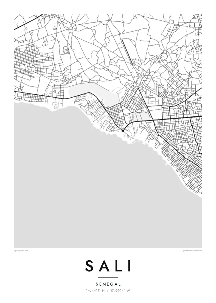
The beach runs as an almost unbroken line along the coast. In black and white it becomes the defining edge of the poster, with the ocean left as open space.
Fakatino mape mukamuka · Senegal
14.4411° N / 17.0194° W
A resort town on Senegal's Petite Côte, laid out along a straight Atlantic beach south of Dakar.


Taha e taone, lima e onoonoaga
Tapaki e taha puhala ke kitia ai ki luga he puipui. Kua tatai e totogi he tau puhala oti — pete he lolomi, poloka, po ke faila HD.
 Tau pikselo mooli · faila lolomi 24 × 36″
Maama mitaki ke lolomi
Ko e 100% e fahi mooli mai he faila lolomi. Ko e tau poster oti — pete kua lolomi, poloka, po ke utu hifo — kua taute ke he ha mautolu a tau tokoluga (server) ke he 300 DPI, hokotia ke he 7,200 × 10,800 piksela, ke maeke ai e tau ala ikiiki tote ke maaliali fakamitaki he lolomi 24 × 36″.
He Pā


Ko e mape
Sali, often written Saly, lies on the Petite Côte, the stretch of Atlantic shore that runs south-east from the Cap-Vert peninsula toward the Saloum delta. It sits just north-west of Mbour and has become one of Senegal's best-known beach destinations. Hotels, residences and villages spread along a long, gently curving sandy coast.
The town's full name, Saly-Portudal, recalls Portudal, a trading post used by Portuguese and later other European merchants on this coast. Today the map shows how tourism has shaped the place. Properties and access roads line the shore, older settlement and newer neighbourhoods sit further inland, and the main road links the town to Mbour and Dakar.
A Sali map poster traces the narrow strip between the road and the sea. The coast forms a clean edge along one side of the frame, and residential streets and resort plots fill the land behind it. It is a simple, strong composition for a place defined above all by its beach and the Atlantic.
The beach runs as an almost unbroken line along the coast. In black and white it becomes the defining edge of the poster, with the ocean left as open space.
Hotels and residences occupy a band close to the shore, each reached by its own access road. This creates a rhythm of short parallel lines between the main road and the sea.
Sali lies just north-west of the fishing town of Mbour, and roads connect the two closely. The map can show them as one continuous stretch of coastal settlement.
Taute ke ha hau
Lafi e aho, taha higoa po ke taha kupu haau, hiki e fakatino, lahi po ke tuaga.
Ko e kitiaaga nakai totogi kua tote e maaliali mo e fakamailoga vai. Ko e tau lolomi mo e tau faila HD kua taute ke he 300 DPI, hokotia ke he 7,200 × 10,800 px, nakai fai fakamailoga vai.
Ko e ha Sali
Sali is where many travellers first see Senegal's coast, and where many Senegalese families spend weekends and holidays. A map of the shoreline makes a restrained souvenir that lasts longer than a photograph and fits easily into any room.
You can personalise the title, subtitle and coordinates, adding the dates of a stay or an anniversary. There are five styles: Classic black & white, Noir, Paper, Blueprint and Sand. Buy the HD files for $9 or order a matte print, with or without a wooden frame.
Talaage e poster Sali| Lahi he lolomi | Maama | Tau faila |
|---|---|---|
| 30 × 40 cm11.8 × 15.7″ | 3,543 × 4,724 px | PNG · PDF |
| 29.7 × 42 cm (A3)11.7 × 16.5″ | 3,508 × 4,961 px | PNG · PDF |
| 42 × 59.4 cm (A2)16.5 × 23.4″ | 4,961 × 7,016 px | PNG · PDF |
| 45.7 × 61 cm18 × 24″ | 5,400 × 7,200 px | PNG · PDF |
| 50 × 70 cm19.7 × 27.6″ | 5,906 × 8,268 px | PNG · PDF |
| 61 × 91.4 cm24 × 36″ | 7,200 × 10,800 px | PNG · PDF |
Ke fakatatai, ko e fakatino noa kua 900 px e laulahi, fai fakamailoga mo e mo e tau mata komipiuta ni. Ko e tau faila HD kua ato hoko ke he 8× e maama ke he tau faahi takitaha mo e lolomi mitaki he lahi katoa he fakatino.
Fifili e taha puhala i luga he kupega, ti fifili e Poster Lolomi — e lahi mo e, kaeke ke manako ai koe, taha poloka — po ke Tau Faila HD Fakaeletonika. Ko e fakaotiaga totogi ko e taha gahua ni, ti ko e kupega he hau a talaaga ka fakafou fakahaga i mua he fakaotiaga e totogi.
Kua lolomi ai ke he pepa mitaki 200 gsm matte he taha he tau lahi ono, mai he 30 × 40 cm ke hoko ke he 24 × 36″. Kamata e tau poster lolomi mai he $39, kua putoia ai e utaaga.
E. Fifili e poloka akau malolō ke he lanu uli, tea, akau oki mooli, po ke akau pouli. Kua fakalataha mo e sioga malolō nakai malepe ti kua mautali ke tautau. Kamata e tau poster poloka mai he $99, kua putoia ai e utaaga.
Nakai totogi e fakafano ke he motu 60+. Ko e fakatino taha kua lolomi he fenoga lolomi ha mautolu kua tata mo e tau motu 30+, kua hoko mai he tau aho gahua 3–7. Maeke ia koe ke kikite e tuaga mo e fakamuitua he lalo he Haku Tau Fakatonu. Ke he falu motu kua 2–5 e tau tapu, ti ka nakai fakafano a mautolu ki ai, to fakaha he api tupe ia ki mua he totogi.
Fakafano mai e taha ata ki a mautolu he loto he 14 e tau aho tali mai he hokoaga, ti to lolomi foki e mautolu nakai totogi po ke liu atu e totogi ki a koe.
E. He editor i luga he kupega nei, hikihiki e matakupu, e matakupu lalo mo e laini coordinates ke he taha mena kua manako a koe ki ai, ti fifili e puhala mo e lahi. Ko e tau talaaga lolomi, poloka mo e fakaeletonika oti kua fakaaoga tonu e hau a fakatino.
Ma e $9 ka moua e koe e tau faila PNG 300 DPI mo e PDF kua mautali ke lolomi he tau lahi ono oti, nakai fai fakamailoga vai, ke lolomi i fe mena. Nakai maopoopo agaia? Utu hifo fakamua e kitiaaga nakai totogi ne fai fakamailoga vai.
Tata mai
