Kiso River levees
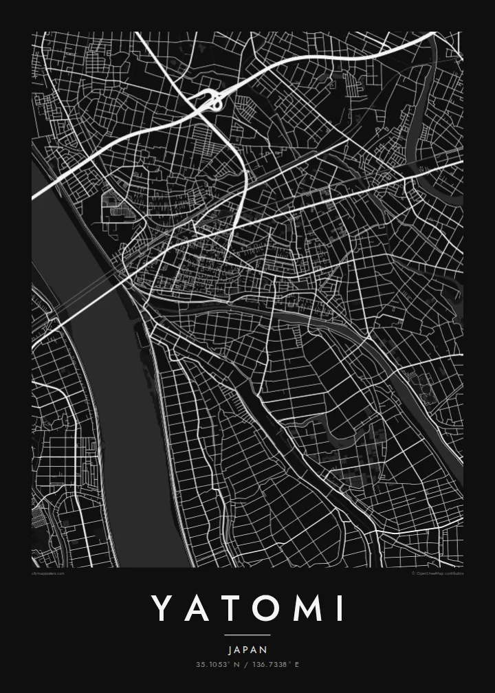
The wide river and its embankments run along the western edge of the city, a long, strong line separating Aichi from Mie.
Fakatino mape mukamuka · Japan
35.1053° N / 136.7338° E
A low-lying Aichi city on the Kiso River delta, laced with drainage channels, rice fields and goldfish ponds west of Nagoya.



Taha e taone, lima e onoonoaga
Tapaki e taha puhala ke kitia ai ki luga he puipui. Kua tatai e totogi he tau puhala oti — pete he lolomi, poloka, po ke faila HD.
 Tau pikselo mooli · faila lolomi 24 × 36″
Maama mitaki ke lolomi
Ko e 100% e fahi mooli mai he faila lolomi. Ko e tau poster oti — pete kua lolomi, poloka, po ke utu hifo — kua taute ke he ha mautolu a tau tokoluga (server) ke he 300 DPI, hokotia ke he 7,200 × 10,800 piksela, ke maeke ai e tau ala ikiiki tote ke maaliali fakamitaki he lolomi 24 × 36″.
He Pā


Ko e mape
Yatomi lies on the delta lands at the western edge of Aichi Prefecture, where the Kiso River forms the boundary with Mie. Much of the city was reclaimed from shallow bays and wetlands over centuries, and a large part of it sits at or below sea level. On a map this history appears as flat, carefully divided land crossed by embankments and drainage channels.
The street pattern is modest and practical, with residential districts clustered along main roads and rail lines, and the rest of the land given over to fields, ponds and waterways. Rivers and canals run roughly north to south toward Ise Bay, and the long embankments of the Kiso on the western side form one of the clearest lines in the composition.
Yatomi is widely known for goldfish farming, a tradition that has made it one of Japan's main producers, and the rectangular breeding ponds add a distinctive geometric texture to the landscape. A Yatomi map poster renders that water-shaped country in fine black lines, from the river levees to the patchwork of ponds and paddies around the town.
The wide river and its embankments run along the western edge of the city, a long, strong line separating Aichi from Mie.
Rectangular breeding ponds sit in neat rows among the fields, forming a repeating pattern that is specific to Yatomi and its goldfish trade.
Straight drainage channels and field boundaries divide land reclaimed from the bay, giving the southern part of the map a calm, ruled geometry.
Taute ke ha hau
Lafi e aho, taha higoa po ke taha kupu haau, hiki e fakatino, lahi po ke tuaga.
Ko e kitiaaga nakai totogi kua tote e maaliali mo e fakamailoga vai. Ko e tau lolomi mo e tau faila HD kua taute ke he 300 DPI, hokotia ke he 7,200 × 10,800 px, nakai fai fakamailoga vai.
Ko e ha Yatomi
For people from Yatomi, and for anyone who knows the flat, watery country west of Nagoya, this map captures a landscape shaped entirely by human effort against water. It is quiet, precise and full of subtle detail.
Add a title, a subtitle such as a year or family name, and the coordinates line, then choose Classic black & white, Noir, Paper, Blueprint or Sand. The $9 download includes A3, A2 and four other sizes as 300 DPI PNG and PDF.
Talaage e poster Yatomi| Lahi he lolomi | Maama | Tau faila |
|---|---|---|
| 30 × 40 cm11.8 × 15.7″ | 3,543 × 4,724 px | PNG · PDF |
| 29.7 × 42 cm (A3)11.7 × 16.5″ | 3,508 × 4,961 px | PNG · PDF |
| 42 × 59.4 cm (A2)16.5 × 23.4″ | 4,961 × 7,016 px | PNG · PDF |
| 45.7 × 61 cm18 × 24″ | 5,400 × 7,200 px | PNG · PDF |
| 50 × 70 cm19.7 × 27.6″ | 5,906 × 8,268 px | PNG · PDF |
| 61 × 91.4 cm24 × 36″ | 7,200 × 10,800 px | PNG · PDF |
Ke fakatatai, ko e fakatino noa kua 900 px e laulahi, fai fakamailoga mo e mo e tau mata komipiuta ni. Ko e tau faila HD kua ato hoko ke he 8× e maama ke he tau faahi takitaha mo e lolomi mitaki he lahi katoa he fakatino.
Fifili e taha puhala i luga he kupega, ti fifili e Poster Lolomi — e lahi mo e, kaeke ke manako ai koe, taha poloka — po ke Tau Faila HD Fakaeletonika. Ko e fakaotiaga totogi ko e taha gahua ni, ti ko e kupega he hau a talaaga ka fakafou fakahaga i mua he fakaotiaga e totogi.
Kua lolomi ai ke he pepa mitaki 200 gsm matte he taha he tau lahi ono, mai he 30 × 40 cm ke hoko ke he 24 × 36″. Kamata e tau poster lolomi mai he $39, kua putoia ai e utaaga.
E. Fifili e poloka akau malolō ke he lanu uli, tea, akau oki mooli, po ke akau pouli. Kua fakalataha mo e sioga malolō nakai malepe ti kua mautali ke tautau. Kamata e tau poster poloka mai he $99, kua putoia ai e utaaga.
Nakai totogi e fakafano ke he motu 60+. Ko e fakatino taha kua lolomi he fenoga lolomi ha mautolu kua tata mo e tau motu 30+, kua hoko mai he tau aho gahua 3–7. Maeke ia koe ke kikite e tuaga mo e fakamuitua he lalo he Haku Tau Fakatonu. Ke he falu motu kua 2–5 e tau tapu, ti ka nakai fakafano a mautolu ki ai, to fakaha he api tupe ia ki mua he totogi.
Fakafano mai e taha ata ki a mautolu he loto he 14 e tau aho tali mai he hokoaga, ti to lolomi foki e mautolu nakai totogi po ke liu atu e totogi ki a koe.
E. He editor i luga he kupega nei, hikihiki e matakupu, e matakupu lalo mo e laini coordinates ke he taha mena kua manako a koe ki ai, ti fifili e puhala mo e lahi. Ko e tau talaaga lolomi, poloka mo e fakaeletonika oti kua fakaaoga tonu e hau a fakatino.
Ma e $9 ka moua e koe e tau faila PNG 300 DPI mo e PDF kua mautali ke lolomi he tau lahi ono oti, nakai fai fakamailoga vai, ke lolomi i fe mena. Nakai maopoopo agaia? Utu hifo fakamua e kitiaaga nakai totogi ne fai fakamailoga vai.
Tata mai
