Converging country roads
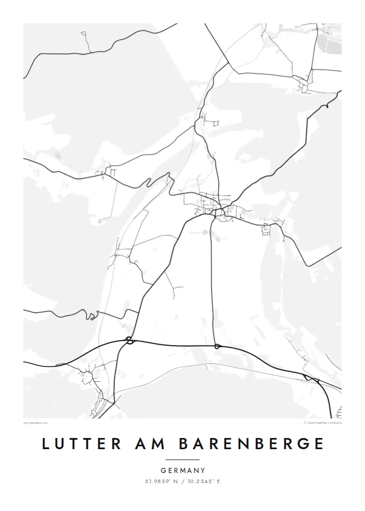
Several local roads meet in the village centre, giving the map a clear focal point from which lines radiate out across the surrounding farmland toward neighbouring villages.
Positala ya mapu yosavuta · Germany
51.9859° N / 10.2545° E
A small village core where country roads meet, framed by open fields and wooded higher ground on the northern edge of the Harz.
Mzinda umodzi, mawonekedwe asanu
Khudzani sitayelo kuti muwone pa khoma. Masitayelo onse amawononga ndalama zofanana — zosindikizidwa, zokutidwa mu chimango kapena ngati mafayilo a HD.
 Ma pixel enieni · fayilo yosindikiza 24 × 36″
Yowala posindikiza
Awa ndi chithunzi 100% chodulidwa cha fayilo yeniyeni yosindikiza. Poster iliyonse — yosindikizidwa, yokutidwa mu chimango kapena yotsitsidwa — imapangidwa pa maseva athu pa 300 DPI, mpaka ma pixel 7,200 × 10,800, choncho ngakhale misewu yaying'ono kwambiri imakhalabe yowoneka bwino pa kope la 24 × 36″.
Pakhoma


Mapu
Lutter am Barenberge sits in the rolling country north of the Harz, in the district of Goslar in Lower Saxony. On a map the village reads as a compact cluster of streets where several roads converge, with farmland spreading out in broad, irregular parcels and patches of woodland rising toward the higher ground. The name itself points to a nearby hill, the Barenberg, a reminder that the landscape here is shaped by gentle relief rather than flat plain.
The place entered European history in August 1626, when the Battle of Lutter was fought nearby during the Thirty Years' War. Imperial and Catholic League troops under Tilly defeated the army of King Christian IV of Denmark, a defeat that sharply weakened the Danish role in the war. Little of that drama shows on paper today. What remains visible is the quiet agricultural pattern that surrounded the battlefield then and still does now.
Since 2021 Lutter has belonged to the town of Langelsheim, yet it keeps its own distinct outline. A Lutter am Barenberge map poster captures that outline in fine lines: the village streets at the centre, the lanes and field tracks running outward, and the softer texture of forest at the margins. It is a small place, and the poster treats it with the same care as any large city.
Several local roads meet in the village centre, giving the map a clear focal point from which lines radiate out across the surrounding farmland toward neighbouring villages.
Large agricultural parcels surround the built-up area, and their boundaries and tracks form a loose geometric background that contrasts with the denser streets of the village.
Wooded higher ground lies within reach of the village, and the Barenberg that gives Lutter its name hints at the rising terrain that eventually becomes the Harz to the south.
Ipangeni yanu
Onjezani tsiku, dzina kapena mawu anu, sinthani mawonekedwe, kukula kapena momwe yaimira.
Chitsanzo chaulere ndi chotsika mu resolution ndipo chili ndi chizindikiro chothira madzi. Zosindikizidwa ndi mafayilo a HD zimapangidwa pa 300 DPI, mpaka ma px 7,200 × 10,800, popanda chizindikiro chothira madzi.
Chifukwa chiyani Lutter am Barenberge
For people with family roots in the Goslar district, or for anyone interested in the Thirty Years' War, this map is a quiet way to keep a specific place in view. It is less about spectacle than about recognising the lanes you know, drawn with clarity and restraint.
You can set your own title and subtitle, add a date such as a wedding or a move, and adjust the coordinates line. Choose between Classic black & white, Noir, Paper, Blueprint and Sand, then download HD files for $9 or order a printed poster.
Odara poster ya Lutter am Barenberge| Kukula kosindikiza | Mphamvu ya chithunzi | Mafayilo |
|---|---|---|
| 30 × 40 cm11.8 × 15.7″ | 3,543 × 4,724 px | PNG · PDF |
| 29.7 × 42 cm (A3)11.7 × 16.5″ | 3,508 × 4,961 px | PNG · PDF |
| 42 × 59.4 cm (A2)16.5 × 23.4″ | 4,961 × 7,016 px | PNG · PDF |
| 45.7 × 61 cm18 × 24″ | 5,400 × 7,200 px | PNG · PDF |
| 50 × 70 cm19.7 × 27.6″ | 5,906 × 8,268 px | PNG · PDF |
| 61 × 91.4 cm24 × 36″ | 7,200 × 10,800 px | PNG · PDF |
Poyerekeza, chithunzi chaulere ndi cha 900 px m'lifupi, chili ndi chizindikiro ndipo ndi cha pa sikirini. Mafayilo a HD ali ndi mphamvu yochulukira mpaka 8× mbali iliyonse ndipo amasindikizika bwino pa kukula konse kwa positala.
Sankhani sitayelo kumtunda kwa tsamba, kenako musankhe Poster Yosindikizidwa — kukula ndi, mukafuna, chimango — kapena Mafayilo a Digital HD. Kulipira kumatenga sitepe imodzi, ndipo tsamba la oda yanu limasinthidwa nthawi yomweyo pambuyo pa kulipira.
Imasindikizidwa pa pepala labwino la matte la 200 gsm mu kukula kumodzi mwa zisanu ndi chimodzi, kuyambira 30 × 40 cm mpaka 24 × 36″. Maposita osindikizidwa amayamba pa $39, kutumiza kuphatikizidwa.
Inde. Sankhani chimango cha mtengo wolimba mu utoto wakuda, woyera, oak wachilengedwe kapena mtengo wakuda. Chimabwera ndi galasi losathyoka ndipo chikonzekera kupachikidwa nthawi yomweyo. Maposita a mu chimango amayamba pa $99, kutumiza kuphatikizidwa.
Kutumiza ndi kwaulere kumayiko oposa 60. Positala iliyonse imasindikizidwa ndi mnzathu wosindikiza wapafupi kwambiri mwa anzathu m'mayiko oposa 30, ndipo nthawi zambiri imafika m'masiku 3–7 antchito. Mukhoza kutsatira momwe oda ilili ndi malo ake pa "Maoda Anga". Mayiko ena amatenga masabata 2–5, ndipo kumene sitinayambe kutumiza, tsambali likuuzani musanalipire.
Titumizireni chithunzi masiku 14 kuchokera pa tsiku la kutumiza ndipo tidzaisindikizanso kwaulere kapena kukubwezerani ndalama zanu.
Inde. Mu chida chokonzera pa tsambali, sinthani mutu, mutu wowonjezera ndi mzere wa ma coordinates kukhala chilichonse chomwe mufuna, ndipo sankhani sitayelo ndi kukula. Maoda osindikizidwa, a mu chimango ndi a digital onse amagwiritsa ntchito kapangidwe kanu enieni.
Pa $9 mumalandira mafayilo a PNG a 300 DPI ndi PDF okonzeka kusindikiza mu kukula konse kwa zisanu ndi chimodzi, popanda chizindikiro chothira madzi, kuti musindikize kulikonse. Simunatsimikize? Tsitsani kaye chitsanzo chaulere chokhala ndi chizindikiro chothira madzi.
Pafupi
