Niger–Benue confluence
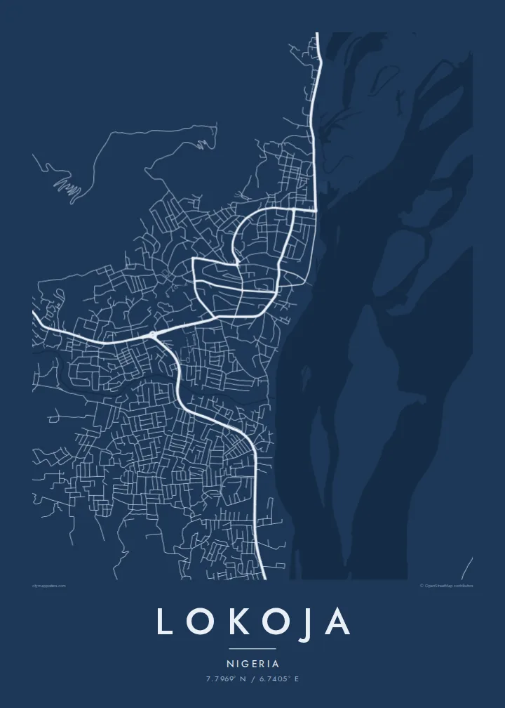
The meeting of Nigeria's two largest rivers dominates the map, a broad Y of open water with sandbars and islands that makes the town's position instantly recognisable.
Poster de mapa minimalista · Nigéria
7.7969° N / 6.7405° E
Two great rivers meet in a wide Y beneath a flat-topped hill, with the town strung along the western bank.



Uma cidade, cinco ambientes
Toque num estilo para o ver na parede. Todos os estilos custam o mesmo — impresso, emoldurado ou em ficheiros HD.
 Pixels reais · ficheiro de impressão 24 × 36″
Nitidez de impressão
Este é um recorte a 100% do ficheiro de impressão real. Todos os pósteres — impressos, emoldurados ou descarregados — são gerados nos nossos servidores a 300 DPI, até 7,200 × 10,800 pixels, para que até as ruas mais pequenas fiquem nítidas numa impressão de 24 × 36″.
Na parede


O mapa
Lokoja sits where the Niger and the Benue join, and on a map that confluence is the whole composition. Two broad channels arrive from the north-west and north-east, merge into a single river flowing south, and leave sandbanks and braided islands in their wake. The town itself runs along the west bank in a narrow band, held between the water and the rising ground behind it.
Above the streets, Mount Patti climbs steeply, its plateau top reached by winding roads and tracks. The hill is tied to a widely told story: the name Nigeria is said to have been coined while looking out over this confluence. Lokoja also served as an early administrative centre under British rule, and today it is the capital of Kogi State, a crossroads between the north and south of the country.
A Lokoja map poster reduces all of this to line and space: the dense streets near the river, the highway threading north towards Abuja, and the pale expanse of water that fills much of the frame. Few city maps are so clearly organised around one natural event, and the result reads almost like a diagram of how rivers shape the places that grow beside them.
The meeting of Nigeria's two largest rivers dominates the map, a broad Y of open water with sandbars and islands that makes the town's position instantly recognisable.
The steep hill rising directly behind the town appears as a tight knot of winding roads, a strong contrast to the flat river plain spread out below it.
Squeezed between hill and water, Lokoja's streets form a long, narrow band that follows the west bank, with newer growth pushing along the main roads.
Personalize-o
Acrescente uma data, um nome ou uma frase sua, e mude o estilo, o tamanho ou a orientação.
A pré-visualização gratuita é de baixa resolução e com marca de água. As impressões e os ficheiros HD são gerados a 300 DPI, até 7,200 × 10,800 px, sem marca de água.
Porquê Lokoja
For people from Kogi State, or anyone who has crossed the confluence, this map holds a sense of arrival: the point where two rivers and several highways come together. It works as a quiet reminder of home, a posting, a journey or a family story tied to the town.
You can set your own title, subtitle and coordinates line, adding a date or a name, and choose from Classic black & white, Noir, Paper, Blueprint or Sand. The HD files cost $9 and arrive without a watermark, or you can order a matte print from partners in more than 30 countries.
Encomendar o póster Lokoja| Tamanho de impressão | Resolução | Ficheiros |
|---|---|---|
| 30 × 40 cm11.8 × 15.7″ | 3,543 × 4,724 px | PNG · PDF |
| 29.7 × 42 cm (A3)11.7 × 16.5″ | 3,508 × 4,961 px | PNG · PDF |
| 42 × 59.4 cm (A2)16.5 × 23.4″ | 4,961 × 7,016 px | PNG · PDF |
| 45.7 × 61 cm18 × 24″ | 5,400 × 7,200 px | PNG · PDF |
| 50 × 70 cm19.7 × 27.6″ | 5,906 × 8,268 px | PNG · PDF |
| 61 × 91.4 cm24 × 36″ | 7,200 × 10,800 px | PNG · PDF |
Para comparação, a pré-visualização gratuita tem 900 px de largura, marca de água e destina-se a ecrãs. Os ficheiros HD têm até 8× a resolução em cada direção e imprimem com nitidez no tamanho total do poster.
Escolha um estilo no topo da página e depois selecione Póster Impresso — um tamanho e, se quiser, uma moldura — ou Ficheiros Digitais HD. O checkout é feito num só passo, e a sua página de encomenda atualiza-se assim que o pagamento é confirmado.
É impresso em papel mate premium de 200 g/m² num de seis tamanhos, de 30 × 40 cm a 24 × 36″. Os pósteres impressos têm preços a partir de $39, portes incluídos.
Sim. Escolha uma moldura de madeira maciça em preto, branco, carvalho natural ou madeira escura. Vem com vidro anti-estilhaço e pronta a pendurar. Os pósteres emoldurados têm preços a partir de $99, portes incluídos.
O envio é grátis para mais de 60 países. Cada pôster é impresso pelo parceiro de impressão mais próximo, entre os nossos parceiros em mais de 30 países, e costuma chegar em 3 a 7 dias úteis. Você pode acompanhar o status e o rastreamento em Meus Pedidos. Alguns países levam de 2 a 5 semanas e, onde ainda não entregamos, o site avisa antes do pagamento.
Envie-nos uma foto até 14 dias após a entrega e reimprimimos gratuitamente ou reembolsamos.
Sim. No editor desta página, altere o título, o subtítulo e a linha de coordenadas como preferir, e escolha um estilo e tamanho. As encomendas impressas, emolduradas e digitais usam exatamente o seu design.
Por $9 recebe ficheiros PNG a 300 DPI e PDF prontos para impressão nos seis tamanhos, sem marca de água, para imprimir onde quiser. Ainda não tem a certeza? Descarregue primeiro uma pré-visualização gratuita com marca de água.
Nas proximidades
