The Indus
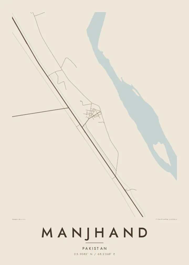
The great river runs to the east of the town, and its broad floodplain forms a wide, open band across one side of the map.
Poster minimalist cu hartă · Pakistan
25.9083° N / 68.2368° E
A Sindh river town on the west bank of the Indus, between the water and the dry hills


Un oraș, cinci atmosfere
Atinge un stil ca să-l vezi pe perete. Toate stilurile costă la fel — tipărite, înrămate sau ca fișiere HD.
 Pixeli reali · fișier de print 24 × 36″
Clar la tipar
Acesta este un decupaj 100% din fișierul de print real. Fiecare poster — tipărit, înrămat sau descărcat — este randat pe serverele noastre la 300 DPI, până la 7,200 × 10,800 pixeli, ca și cele mai fine străzi să rămână clare la un print de 24 × 36″.
Pe perete


Harta
Manjhand is in Jamshoro District in Sindh, on the western side of the Indus. On the map, it sits between two very different landscapes: the flat, irrigated floodplain along the river and the dry, rocky ground that rises toward the Kirthar hills to the west. The town grows along the line where these meet.
The streets are compact and irregular at the centre, where the houses cluster closely together. Roads lead out toward the river and to neighbouring towns along the Indus. Around the town, irrigation channels and field boundaries divide the farmland into narrow plots, forming a fine texture of lines across the lower part of the frame.
Like many towns along the lower Indus, Manjhand depends on the river for water and farming, and its setting shapes how people live. A Manjhand map poster shows a small town between river and hills, with the fields and canals that support it spread out around the streets.
The great river runs to the east of the town, and its broad floodplain forms a wide, open band across one side of the map.
Irrigation canals and field boundaries cut the land around the town into narrow plots, a detailed pattern of fine lines.
Toward the west, the farmland gives way to dry, rising ground, where the streets thin out and the landscape becomes open and bare.
Personalizează-l
Adaugă o dată, un nume sau un rând scris de tine, schimbă stilul, dimensiunea sau orientarea.
Previzualizarea gratuită are rezoluție redusă și filigran. Posterele tipărite și fișierele HD sunt randate la 300 DPI, până la 7,200 × 10,800 px, fără filigran.
De ce Manjhand
A map of Manjhand is a personal piece for people who grew up there or whose families come from the town, especially those living far away. It records the town, the fields and the river that define it.
You can write the title and subtitle in the form you prefer and add exact coordinates. Choose from five styles: Classic black & white, Noir, Paper, Blueprint and Sand. Download 300 DPI files in six sizes, or order a printed poster.
Comandă posterul Manjhand| Dimensiune tipar | Rezoluție | Fișiere |
|---|---|---|
| 30 × 40 cm (11.8 × 15.7″) | 3,543 × 4,724 px | PNG · PDF |
| 29.7 × 42 cm (A3, 11.7 × 16.5″) | 3,508 × 4,961 px | PNG · PDF |
| 42 × 59.4 cm (A2, 16.5 × 23.4″) | 4,961 × 7,016 px | PNG · PDF |
| 45.7 × 61 cm (18 × 24″) | 5,400 × 7,200 px | PNG · PDF |
| 50 × 70 cm (19.7 × 27.6″) | 5,906 × 8,268 px | PNG · PDF |
| 61 × 91.4 cm (24 × 36″) | 7,200 × 10,800 px | PNG · PDF |
Pentru comparație, previzualizarea gratuită are 900 px lățime, are filigran și este destinată ecranelor. Fișierele HD au o rezoluție de până la 8 ori mai mare pe fiecare direcție și se tipăresc impecabil la dimensiunea completă a posterului.
Alege un stil în partea de sus a paginii, apoi selectează Poster Tipărit — o dimensiune și, dacă vrei, o ramă — sau Fișiere Digitale HD. Plata se face într-un singur pas, iar pagina comenzii tale se actualizează imediat ce plata este confirmată.
Este tipărit pe hârtie mată premium de 200 g/m² în una din șase dimensiuni, de la 30 × 40 cm la 24 × 36″. Posterele tipărite pornesc de la $39, livrare inclusă.
Da. Alege o ramă din lemn masiv în negru, alb, stejar natural sau lemn închis la culoare. Vine cu geam antișoc și e gata de agățat pe perete. Posterele înrămate pornesc de la $99, livrare inclusă.
Livrarea este gratuită în toată lumea. Fiecare poster este tipărit de cel mai apropiat dintre partenerii noștri de tipar din peste 30 de țări și ajunge de obicei în 3–7 zile lucrătoare. Poți urmări starea comenzii și numărul de urmărire la Comenzile mele. Câteva țări necesită 2–5 săptămâni, iar acolo unde nu livrăm încă, site-ul te anunță înainte de plată.
Trimite-ne o poză în termen de 14 zile de la livrare și îl vom retipări gratuit sau îți vom returna banii.
Da. În editorul de pe această pagină, schimbă titlul, subtitlul și linia cu coordonatele cum dorești, apoi alege un stil și o dimensiune. Comenzile tipărite, înrămate și digitale folosesc exact designul tău.
Pentru $9 primești fișiere PNG la 300 DPI și PDF pregătite pentru print, în toate cele șase dimensiuni, fără filigran, gata de tipărit oriunde. Nu ești sigur încă? Descarcă mai întâi o previzualizare gratuită cu filigran.
În apropiere
