Funai Castle
The castle ruins in the centre, with moats and stone walls, form a clear square. The surrounding streets are laid out in an orderly grid around it.
Poster minimalist cu hartă · Japonia
33.2333° N / 131.6000° E
A bayside city on Kyushu where two rivers reach the sea, with castle moats at the centre and industry along the shore



Un oraș, cinci atmosfere
Atinge un stil ca să-l vezi pe perete. Toate stilurile costă la fel — tipărite, înrămate sau ca fișiere HD.
 Pixeli reali · fișier de print 24 × 36″
Clar la tipar
Acesta este un decupaj 100% din fișierul de print real. Fiecare poster — tipărit, înrămat sau descărcat — este randat pe serverele noastre la 300 DPI, până la 7,200 × 10,800 pixeli, ca și cele mai fine străzi să rămână clare la un print de 24 × 36″.
Pe perete


Harta
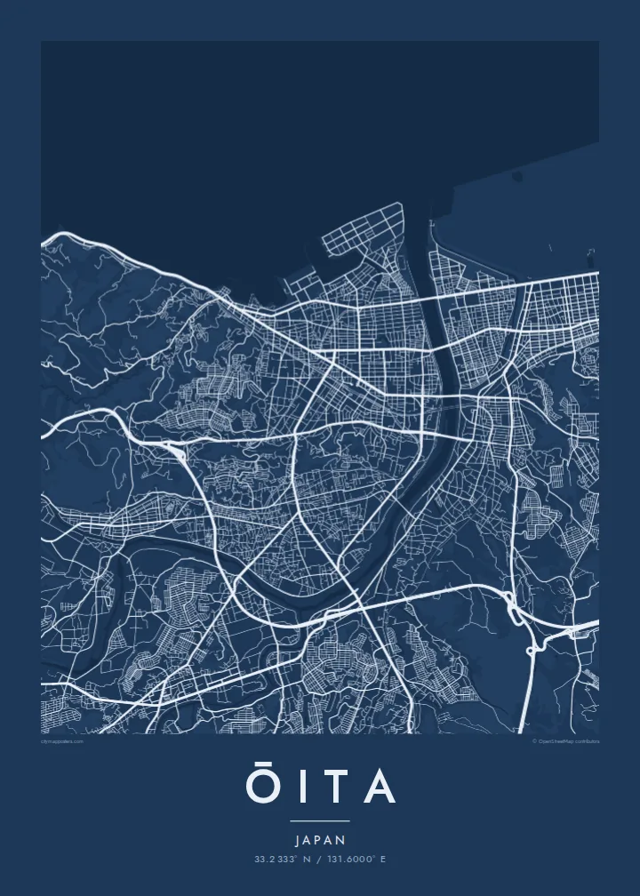
Ōita lies on the northern coast of Kyushu, facing Beppu Bay, and its map is shaped by two rivers, the Ōita and the Ōno, which reach the sea on either side of the city. Between them, the centre is laid out in a regular grid around the remains of Funai Castle, whose moats and stone walls still form a clear square in the street pattern. Much of the coastline has been reclaimed for industry.
In the sixteenth century the area was ruled by the Ōtomo clan, and under Ōtomo Sōrin the town of Funai became one of Japan's early points of contact with Europe. Francis Xavier visited in 1551. Today Ōita is the prefectural capital, and it sits right next to Beppu, one of Japan's best-known hot spring towns.
An Ōita map poster brings together the grid of the castle town, the two river mouths and the straight edges of the reclaimed coast. The hills behind the city frame it on the landward side. In black and white the castle's square moats, the river curves and the man-made shoreline create a composition that feels both historical and modern.
The castle ruins in the centre, with moats and stone walls, form a clear square. The surrounding streets are laid out in an orderly grid around it.
The Ōita and Ōno rivers enter Beppu Bay on either side of the city, framing the urban area with long, curving lines of water.
Large areas of the shore were filled in for industry. On the map they appear as straight-edged blocks pushing into the bay.
Personalizează-l
Adaugă o dată, un nume sau un rând scris de tine, schimbă stilul, dimensiunea sau orientarea.
Previzualizarea gratuită are rezoluție redusă și filigran. Posterele tipărite și fișierele HD sunt randate la 300 DPI, până la 7,200 × 10,800 px, fără filigran.
De ce Ōita
Ōita is a map for people from Kyushu, for those who have lived in the prefecture, and for travellers who remember the bay and the nearby hot springs. The castle square and the rivers make it easy to recognise.
Personalise the title, subtitle and coordinates line with a date or phrase, and choose Classic black & white, Noir, Paper, Blueprint or Sand. Blueprint suits the bay and the industrial coast.
Comandă posterul Ōita| Dimensiune tipar | Rezoluție | Fișiere |
|---|---|---|
| 30 × 40 cm11.8 × 15.7″ | 3,543 × 4,724 px | PNG · PDF |
| 29.7 × 42 cm (A3)11.7 × 16.5″ | 3,508 × 4,961 px | PNG · PDF |
| 42 × 59.4 cm (A2)16.5 × 23.4″ | 4,961 × 7,016 px | PNG · PDF |
| 45.7 × 61 cm18 × 24″ | 5,400 × 7,200 px | PNG · PDF |
| 50 × 70 cm19.7 × 27.6″ | 5,906 × 8,268 px | PNG · PDF |
| 61 × 91.4 cm24 × 36″ | 7,200 × 10,800 px | PNG · PDF |
Pentru comparație, previzualizarea gratuită are 900 px lățime, are filigran și este destinată ecranelor. Fișierele HD au o rezoluție de până la 8 ori mai mare pe fiecare direcție și se tipăresc impecabil la dimensiunea completă a posterului.
Alege un stil în partea de sus a paginii, apoi selectează Poster Tipărit — o dimensiune și, dacă vrei, o ramă — sau Fișiere Digitale HD. Plata se face într-un singur pas, iar pagina comenzii tale se actualizează imediat ce plata este confirmată.
Este tipărit pe hârtie mată premium de 200 g/m² în una din șase dimensiuni, de la 30 × 40 cm la 24 × 36″. Posterele tipărite pornesc de la $39, livrare inclusă.
Da. Alege o ramă din lemn masiv în negru, alb, stejar natural sau lemn închis la culoare. Vine cu geam antișoc și e gata de agățat pe perete. Posterele înrămate pornesc de la $99, livrare inclusă.
Transportul este gratuit în peste 60 de țări. Fiecare poster este tipărit de cel mai apropiat partener de tipar dintre cei din peste 30 de țări și ajunge, de obicei, în 3–7 zile lucrătoare. Poți urmări starea comenzii și coletul în Comenzile mele. În câteva țări livrarea durează 2–5 săptămâni, iar acolo unde încă nu livrăm, site-ul te anunță înainte de plată.
Trimite-ne o poză în termen de 14 zile de la livrare și îl vom retipări gratuit sau îți vom returna banii.
Da. În editorul de pe această pagină, schimbă titlul, subtitlul și linia cu coordonatele cum dorești, apoi alege un stil și o dimensiune. Comenzile tipărite, înrămate și digitale folosesc exact designul tău.
Pentru $9 primești fișiere PNG la 300 DPI și PDF pregătite pentru print, în toate cele șase dimensiuni, fără filigran, gata de tipărit oriunde. Nu ești sigur încă? Descarcă mai întâi o previzualizare gratuită cu filigran.
În apropiere
