Kiir River
The river, also called Bahr el-Arab, runs across the plain south of the town. It is central to grazing, farming and seasonal movement throughout the region.
Posta faʻafanua faigofie · Sudan
9.5953° N / 28.4349° E
A town on the flat, seasonally flooded plains between Sudan and South Sudan, near the river the region depends on


Tasi le aai, lagona e lima
Tapi se sitaili e vaai ai i luga o le puipui. E tutusa uma le tau o sitaili — pe lolomiina, faapipiiina, pe avea ma faila HD.
 Pika Moni · Faila Lolomi 24 × 36″
Manino mo le lolomi
O se vaega atoa (100%) lenei mai le faila lolomi moni. O posita uma — pe lolomiina, faapipiiina pe download mai — e faia i luga o a matou server i le 300 DPI, e oo atu i le 7,200 × 10,800 pika, ina ia manino pea auala laiti i luga o se lolomiga 24 × 36″.
I luga o le puipui


Le faʻafanua
Abyei lies in a flat savannah region on the border between Sudan and South Sudan, and it is known internationally for the unresolved question of which country it belongs to. The area has its own special administrative status, and a United Nations peacekeeping force has been stationed there since 2011. It is home to the Ngok Dinka, and Misseriya herders move through it seasonally with their cattle.
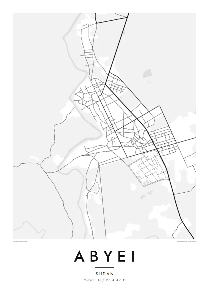
On a map, the landscape is almost entirely level. The Kiir River, also called the Bahr el-Arab, crosses the region to the south of the town, and seasonal watercourses and low-lying wetlands spread across the plain in the rainy months. The town is a compact cluster of streets and compounds, with tracks leading outward across open country.
An Abyei map poster doesn't claim to settle anything. It records a place that many people call home and that others know only from the news: a town, its roads and the waterways that shape life around it. For people from Abyei, for aid workers and for peacekeepers who have served there, the map holds a personal meaning that goes beyond politics.
The river, also called Bahr el-Arab, runs across the plain south of the town. It is central to grazing, farming and seasonal movement throughout the region.
Abyei itself appears as a tight group of streets and compounds. It stands out sharply against the large, open country around it.
Unpaved routes lead away from the town in several directions. They connect it to villages, grazing lands and the wider region.
Fai mo oe
Faʻaopoopo se aso, se igoa po o sau lava upu, sui le sitaili, lapoʻa po o le itu.
O le preview e leai se totogi e maualalo le resolution ma iai se watermark. O lolomi ma faila HD e faia i le 300 DPI, e oo atu i le 7,200 × 10,800 px, e aunoa ma se watermark.
Aisea Abyei
For people from Abyei living elsewhere, and for those who have worked or served there, this map is a way of keeping the place in view on its own terms: as streets, a river and a home, not a headline.
Write the title and subtitle as you see fit, including a name, a date or a dedication, and edit the coordinates line. Choose from Classic black & white, Noir, Paper, Blueprint and Sand. Sand suits the savannah.
Faatau le posita Abyei| Lapoʻa lolomi | Manino | Faila |
|---|---|---|
| 30 × 40 cm (11.8 × 15.7″) | 3,543 × 4,724 px | PNG · PDF |
| 29.7 × 42 cm (A3, 11.7 × 16.5″) | 3,508 × 4,961 px | PNG · PDF |
| 42 × 59.4 cm (A2, 16.5 × 23.4″) | 4,961 × 7,016 px | PNG · PDF |
| 45.7 × 61 cm (18 × 24″) | 5,400 × 7,200 px | PNG · PDF |
| 50 × 70 cm (19.7 × 27.6″) | 5,906 × 8,268 px | PNG · PDF |
| 61 × 91.4 cm (24 × 36″) | 7,200 × 10,800 px | PNG · PDF |
Ae faʻatusatusa, o le faʻataʻitaʻiga e leai se totogi e 900 px le lautele, e iai le faʻailoga vai ma e mo mata. O faila HD e oʻo atu i le 8× le manino i itu taʻitasi ma e lolomi manino i le lapoʻa atoa o le posta.
Filifili se sitaili i le pito i luga o le itulau, ona filifili lea o le Posita Lolomi — se lapopoa ma, afai e te fiafia, se faavaa — po o Faila HD Numera. E na o le tasi laasaga o le Checkout, ma o le a fesuia'i lou itulau o oka i le taimi lava e mae'a ai le totogi.
E lolomiina i luga o pepa matte maualuga le tulaga e 200 gsm, i se tasi o lapopoa e ono, mai le 30 × 40 cm i le 24 × 36″. E amata le tau o posita lolomi mai le $39, aofia ai le auina atu.
Ioe. Filifili se faavaa laau malosi i le lanu uliuli, sina, oak masani, po o le laau pogisa. E aofia ai se tioata e le gau ma ua saunia e tautau i luga. E amata le tau o posita faavaa mai le $99, aofia ai le auina atu.
E leai se totogi mo le uta i le lalolagi atoa. O poster ta'itasi e lolomi e le paaga lolomi e latalata mai i matou i atunuu e 30+, ma e masani ona taunuu i aso faigaluega e 3–7. E mafai ona e mulimuli i le tulaga ma le tracking i le "Aʻu Oka". O nisi atunuu e 2–5 vaiaso, ma i atunuu matou te lei tuuina atu ai, e taʻu atu e le saite iā te oe ae e te leʻi totogiina.
Auina mai se ata i totonu o le 14 aso talu ona taunuu, ma o le a matou toe lolomiina e leai se totogi po o le toe faafoi atu lau tupe.
Ioe. I totonu o le editor i lenei itulau, suia le ulutala, le ulutala laititi ma le laina o coordinates i soo se mea e te fiafia i ai, ma filifili se sitaili ma le lapopoa. O oka lolomi, faavaa ma numera e faaaoga uma lava lau mamanu.
Mo le $9 e te maua ai faila PNG 300 DPI ma PDF ua saunia mo le lolomi i lapopoa uma e ono, e aunoa ma se watermark, e mafai ona lolomi i soo se mea. Le mautinoa lava? Download muamua se preview e leai se totogi ma le watermark.
Latalata ane
