Fraser River edge
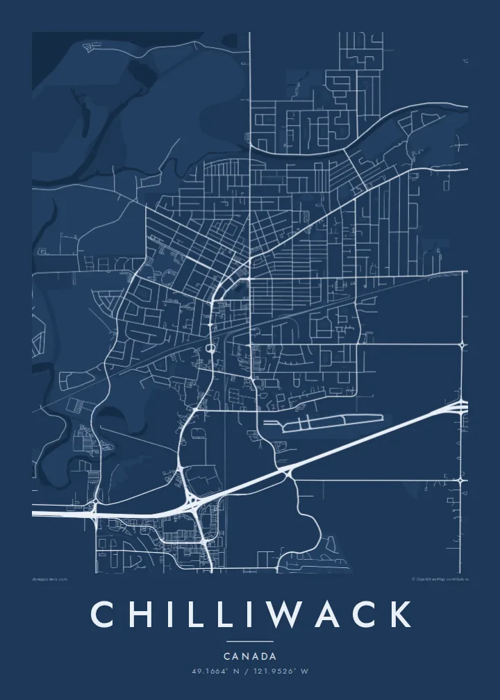
The wide, braided Fraser forms the northern boundary, with sandbars and side channels. It adds a loose, organic edge to an otherwise geometric map.
Posta faʻafanua faigofie · Canada
49.1664° N / 121.9526° W
Farm grids on the flat Fraser Valley floor that stop abruptly where the Cascade foothills rise to the south



Tasi le aai, lagona e lima
Tapi se sitaili e vaai ai i luga o le puipui. E tutusa uma le tau o sitaili — pe lolomiina, faapipiiina, pe avea ma faila HD.
 Pika Moni · Faila Lolomi 24 × 36″
Manino mo le lolomi
O se vaega atoa (100%) lenei mai le faila lolomi moni. O posita uma — pe lolomiina, faapipiiina pe download mai — e faia i luga o a matou server i le 300 DPI, e oo atu i le 7,200 × 10,800 pika, ina ia manino pea auala laiti i luga o se lolomiga 24 × 36″.
I luga o le puipui


Le faʻafanua
Chilliwack sits on the floor of the Fraser Valley, about 100 km east of Vancouver. The Fraser River forms the northern edge of the city, and the mountains close in from the south and east. Between them the land is almost perfectly flat. It is divided into long rectangular fields and straight rural roads that look like a ruled page from above.
The urban core is a modest grid around the old downtown, with newer subdivisions spreading toward Sardis and Vedder. The Vedder and Chilliwack rivers come out of the mountains in the south, and Cultus Lake lies in a valley beyond. On the Chilliwack map poster the eye moves from the orderly farmland to the tangle of roads where the valley meets the slopes.
The area is part of the traditional territory of the Stó:lō people, and the name comes from a Halq'eméylem word. Agriculture has shaped the valley for a long time, especially dairy and berry farming. The former Canadian Forces Base Chilliwack has been redeveloped, and its layout is still visible in the southern part of the city.
The wide, braided Fraser forms the northern boundary, with sandbars and side channels. It adds a loose, organic edge to an otherwise geometric map.
Straight roads and field boundaries cover the valley floor in long rectangles. This is the most distinctive texture of the Chilliwack map.
To the south the grid gives way to winding roads and river valleys leading toward Cultus Lake. It shows exactly where the flat land ends.
Fai mo oe
Faʻaopoopo se aso, se igoa po o sau lava upu, sui le sitaili, lapoʻa po o le itu.
O le preview e leai se totogi e maualalo le resolution ma iai se watermark. O lolomi ma faila HD e faia i le 300 DPI, e oo atu i le 7,200 × 10,800 px, e aunoa ma se watermark.
Aisea Chilliwack
The map is popular with people who live in the valley, including farming families and anyone who has moved out from the coast for more space. It shows the valley as it is: fields, river and mountains in one view.
You can add a family name, a farm name or a moving-in date as the title, and adjust the subtitle and coordinates. Five styles are available: Classic black & white, Noir, Paper, Blueprint and Sand. Sand suits the agricultural setting.
Faatau le posita Chilliwack| Lapoʻa lolomi | Manino | Faila |
|---|---|---|
| 30 × 40 cm11.8 × 15.7″ | 3,543 × 4,724 px | PNG · PDF |
| 29.7 × 42 cm (A3)11.7 × 16.5″ | 3,508 × 4,961 px | PNG · PDF |
| 42 × 59.4 cm (A2)16.5 × 23.4″ | 4,961 × 7,016 px | PNG · PDF |
| 45.7 × 61 cm18 × 24″ | 5,400 × 7,200 px | PNG · PDF |
| 50 × 70 cm19.7 × 27.6″ | 5,906 × 8,268 px | PNG · PDF |
| 61 × 91.4 cm24 × 36″ | 7,200 × 10,800 px | PNG · PDF |
Ae faʻatusatusa, o le faʻataʻitaʻiga e leai se totogi e 900 px le lautele, e iai le faʻailoga vai ma e mo mata. O faila HD e oʻo atu i le 8× le manino i itu taʻitasi ma e lolomi manino i le lapoʻa atoa o le posta.
Filifili se sitaili i le pito i luga o le itulau, ona filifili lea o le Posita Lolomi — se lapopoa ma, afai e te fiafia, se faavaa — po o Faila HD Numera. E na o le tasi laasaga o le Checkout, ma o le a fesuia'i lou itulau o oka i le taimi lava e mae'a ai le totogi.
E lolomiina i luga o pepa matte maualuga le tulaga e 200 gsm, i se tasi o lapopoa e ono, mai le 30 × 40 cm i le 24 × 36″. E amata le tau o posita lolomi mai le $39, aofia ai le auina atu.
Ioe. Filifili se faavaa laau malosi i le lanu uliuli, sina, oak masani, po o le laau pogisa. E aofia ai se tioata e le gau ma ua saunia e tautau i luga. E amata le tau o posita faavaa mai le $99, aofia ai le auina atu.
E leai se totogi o le auina atu i atunuu e 60+. O pepa ata taʻitasi e lolomiina e le tasi o matou paaga lolomi e latalata mai i atunuu e 30+, ma e masani ona taunuu i le 3–7 aso faigaluega. E mafai ona e mulimulitaia le tulaga ma le sailiga i lalo o My Orders. O nisi atunuu e 2–5 vaiaso, ma i nofoaga e lei matou auina atu iai, e taʻu atu e le saite ia te oe a o lei totogi.
Auina mai se ata i totonu o le 14 aso talu ona taunuu, ma o le a matou toe lolomiina e leai se totogi po o le toe faafoi atu lau tupe.
Ioe. I totonu o le editor i lenei itulau, suia le ulutala, le ulutala laititi ma le laina o coordinates i soo se mea e te fiafia i ai, ma filifili se sitaili ma le lapopoa. O oka lolomi, faavaa ma numera e faaaoga uma lava lau mamanu.
Mo le $9 e te maua ai faila PNG 300 DPI ma PDF ua saunia mo le lolomi i lapopoa uma e ono, e aunoa ma se watermark, e mafai ona lolomi i soo se mea. Le mautinoa lava? Download muamua se preview e leai se totogi ma le watermark.
Latalata ane
