Great Belt link
The fixed link to Zealand leaves Funen's east coast near Nyborg and crosses the strait by way of the small island of Sprogø. On the map it is a long, straight line across open water.
Posta faʻafanua faigofie · Denmark
55.3367° N / 10.2666° E
A broad, rounded Danish island between two straits, with Odense near its centre and an archipelago scattered off its southern coast


Tasi le aai, lagona e lima
Tapi se sitaili e vaai ai i luga o le puipui. E tutusa uma le tau o sitaili — pe lolomiina, faapipiiina, pe avea ma faila HD.
 Pika Moni · Faila Lolomi 24 × 36″
Manino mo le lolomi
O se vaega atoa (100%) lenei mai le faila lolomi moni. O posita uma — pe lolomiina, faapipiiina pe download mai — e faia i luga o a matou server i le 300 DPI, e oo atu i le 7,200 × 10,800 pika, ina ia manino pea auala laiti i luga o se lolomiga 24 × 36″.
I luga o le puipui


Le faʻafanua
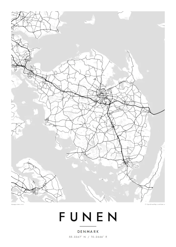
Funen lies between Jutland and Zealand, and on a map it sits squarely in the middle of Denmark, with the Little Belt to the west and the Great Belt to the east. The island is broad and compact. Country roads cross gently rolling farmland, small towns are spaced evenly across the land, and the coastline is cut by shallow fjords and bays.
Odense, the island's largest city and one of the oldest in Denmark, sits near the centre. Ring roads surround its historic core, and a canal leads north to Odense Fjord. The city is the birthplace of Hans Christian Andersen. Bridges carry road and rail west to Jutland, and the long Great Belt link runs east toward Zealand.
South of the island lies the South Funen Archipelago, with Tåsinge, Ærø and many smaller islands reached by bridge and ferry. Castles and manor estates are scattered across the countryside, among them Egeskov with its moat. A Funen map poster shows the island as a hub: the city at the centre, bridges on either side and islands trailing off to the south.
The fixed link to Zealand leaves Funen's east coast near Nyborg and crosses the strait by way of the small island of Sprogø. On the map it is a long, straight line across open water.
At the heart of the island, ring roads enclose Odense's old centre. The river Odense Å winds through it and through parks, and a canal carries on north to the fjord.
Off the south coast, a scatter of islands and islets breaks up the water around Svendborg Sound. It turns the bottom of the map into a mosaic of small coastlines.
Fai mo oe
Faʻaopoopo se aso, se igoa po o sau lava upu, sui le sitaili, lapoʻa po o le itu.
O le preview e leai se totogi e maualalo le resolution ma iai se watermark. O lolomi ma faila HD e faia i le 300 DPI, e oo atu i le 7,200 × 10,800 px, e aunoa ma se watermark.
Aisea Funen
This is a map for people from Odense, Svendborg or the small towns in between, and for anyone who thinks of Funen as the green middle of Denmark. The rounded shape, the bridges and the southern islands give the print a pleasing balance.
You can personalise the title, subtitle and coordinates, add a date that matters to you, and choose one of five styles. The $9 digital files cover six sizes, including 50×70 cm and A2, each as a 300 DPI PNG and a print-ready PDF.
Faatau le posita Funen| Lapoʻa lolomi | Manino | Faila |
|---|---|---|
| 30 × 40 cm (11.8 × 15.7″) | 3,543 × 4,724 px | PNG · PDF |
| 29.7 × 42 cm (A3, 11.7 × 16.5″) | 3,508 × 4,961 px | PNG · PDF |
| 42 × 59.4 cm (A2, 16.5 × 23.4″) | 4,961 × 7,016 px | PNG · PDF |
| 45.7 × 61 cm (18 × 24″) | 5,400 × 7,200 px | PNG · PDF |
| 50 × 70 cm (19.7 × 27.6″) | 5,906 × 8,268 px | PNG · PDF |
| 61 × 91.4 cm (24 × 36″) | 7,200 × 10,800 px | PNG · PDF |
Ae faʻatusatusa, o le faʻataʻitaʻiga e leai se totogi e 900 px le lautele, e iai le faʻailoga vai ma e mo mata. O faila HD e oʻo atu i le 8× le manino i itu taʻitasi ma e lolomi manino i le lapoʻa atoa o le posta.
Filifili se sitaili i le pito i luga o le itulau, ona filifili lea o le Posita Lolomi — se lapopoa ma, afai e te fiafia, se faavaa — po o Faila HD Numera. E na o le tasi laasaga o le Checkout, ma o le a fesuia'i lou itulau o oka i le taimi lava e mae'a ai le totogi.
E lolomiina i luga o pepa matte maualuga le tulaga e 200 gsm, i se tasi o lapopoa e ono, mai le 30 × 40 cm i le 24 × 36″. E amata le tau o posita lolomi mai le {printFrom}, aofia ai le auina atu.
Ioe. Filifili se faavaa laau malosi i le lanu uliuli, sina, oak masani, po o le laau pogisa. E aofia ai se tioata e le gau ma ua saunia e tautau i luga. E amata le tau o posita faavaa mai le {framedFrom}, aofia ai le auina atu.
E leai se totogi mo le uta i le lalolagi atoa. O poster ta'itasi e lolomi e le paaga lolomi e latalata mai i matou i atunuu e 30+, ma e masani ona taunuu i aso faigaluega e 3–7. E mafai ona e mulimuli i le tulaga ma le tracking i le "Aʻu Oka". O nisi atunuu e 2–5 vaiaso, ma i atunuu matou te lei tuuina atu ai, e taʻu atu e le saite iā te oe ae e te leʻi totogiina.
Auina mai se ata i totonu o le 14 aso talu ona taunuu, ma o le a matou toe lolomiina e leai se totogi po o le toe faafoi atu lau tupe.
Ioe. I totonu o le editor i lenei itulau, suia le ulutala, le ulutala laititi ma le laina o coordinates i soo se mea e te fiafia i ai, ma filifili se sitaili ma le lapopoa. O oka lolomi, faavaa ma numera e faaaoga uma lava lau mamanu.
Mo le $9 e te maua ai faila PNG 300 DPI ma PDF ua saunia mo le lolomi i lapopoa uma e ono, e aunoa ma se watermark, e mafai ona lolomi i soo se mea. Le mautinoa lava? Download muamua se preview e leai se totogi ma le watermark.
Latalata ane
