Two rivers meeting
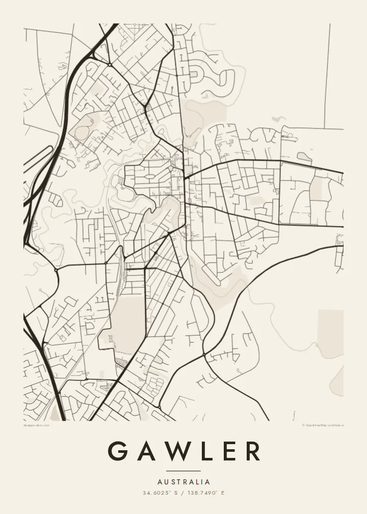
The North Para and South Para curve around the old town and meet to form the Gawler River, which gives the plan a natural frame on two sides.
Posta faʻafanua faigofie · Australia
34.6025° S / 138.7490° E
A colonial town plan set in the fork where the North and South Para rivers meet to form the Gawler River




Tasi le aai, lagona e lima
Tapi se sitaili e vaai ai i luga o le puipui. E tutusa uma le tau o sitaili — pe lolomiina, faapipiiina, pe avea ma faila HD.
 Pika Moni · Faila Lolomi 24 × 36″
Manino mo le lolomi
O se vaega atoa (100%) lenei mai le faila lolomi moni. O posita uma — pe lolomiina, faapipiiina pe download mai — e faia i luga o a matou server i le 300 DPI, e oo atu i le 7,200 × 10,800 pika, ina ia manino pea auala laiti i luga o se lolomiga 24 × 36″.
I luga o le puipui


Le faʻafanua
Gawler, north of Adelaide, was laid out in 1839 and is usually credited to Colonel William Light, the surveyor of Adelaide itself. Its plan still shows clearly from above. A formal grid with squares and a long main street sits on the tongue of land between two rivers. It is one of the most legible nineteenth-century town layouts in South Australia and draws cleanly in black and white.
The North Para and South Para rivers bend around the old town and join on its western side to form the Gawler River. Their tree-lined courses appear on the map as soft, winding bands against the straight streets. Murray Street, the historic main street, runs through the centre, and the railway and newer suburbs spread outward across the surrounding plain and low hills.
Gawler is also a gateway to the Barossa Valley, which starts just to the northeast, so vineyards and farmland lie close to the town's edges. A Gawler map poster captures the planned grid, the enclosing rivers and the looser suburban growth beyond them. It is a clear record of how a surveyed colonial town fitted itself to a river fork.
The North Para and South Para curve around the old town and meet to form the Gawler River, which gives the plan a natural frame on two sides.
The 1839 survey laid out regular streets and open squares on the land between the rivers. It is still the clear, ordered core of the modern map.
The historic main street runs through the centre of town. It is the line the rest of the old grid organises itself around.
Fai mo oe
Faʻaopoopo se aso, se igoa po o sau lava upu, sui le sitaili, lapoʻa po o le itu.
O le preview e leai se totogi e maualalo le resolution ma iai se watermark. O lolomi ma faila HD e faia i le 300 DPI, e oo atu i le 7,200 × 10,800 px, e aunoa ma se watermark.
Aisea Gawler
Gawler has a plan with a clear intention behind it, and that comes through well in a minimalist print. It suits people who live in the town or commute from it, and anyone with ties to the Barossa or to South Australian history.
You can personalise the title, the subtitle and the coordinates line, whether that means a street address or the year you moved in. Choose from Classic, Noir, Paper, Blueprint and Sand. The HD files cost $9, and printed posters ship from print partners in more than 30 countries.
Faatau le posita Gawler| Lapoʻa lolomi | Manino | Faila |
|---|---|---|
| 30 × 40 cm11.8 × 15.7″ | 3,543 × 4,724 px | PNG · PDF |
| 29.7 × 42 cm (A3)11.7 × 16.5″ | 3,508 × 4,961 px | PNG · PDF |
| 42 × 59.4 cm (A2)16.5 × 23.4″ | 4,961 × 7,016 px | PNG · PDF |
| 45.7 × 61 cm18 × 24″ | 5,400 × 7,200 px | PNG · PDF |
| 50 × 70 cm19.7 × 27.6″ | 5,906 × 8,268 px | PNG · PDF |
| 61 × 91.4 cm24 × 36″ | 7,200 × 10,800 px | PNG · PDF |
Ae faʻatusatusa, o le faʻataʻitaʻiga e leai se totogi e 900 px le lautele, e iai le faʻailoga vai ma e mo mata. O faila HD e oʻo atu i le 8× le manino i itu taʻitasi ma e lolomi manino i le lapoʻa atoa o le posta.
Filifili se sitaili i le pito i luga o le itulau, ona filifili lea o le Posita Lolomi — se lapopoa ma, afai e te fiafia, se faavaa — po o Faila HD Numera. E na o le tasi laasaga o le Checkout, ma o le a fesuia'i lou itulau o oka i le taimi lava e mae'a ai le totogi.
E lolomiina i luga o pepa matte maualuga le tulaga e 200 gsm, i se tasi o lapopoa e ono, mai le 30 × 40 cm i le 24 × 36″. E amata le tau o posita lolomi mai le $39, aofia ai le auina atu.
Ioe. Filifili se faavaa laau malosi i le lanu uliuli, sina, oak masani, po o le laau pogisa. E aofia ai se tioata e le gau ma ua saunia e tautau i luga. E amata le tau o posita faavaa mai le $99, aofia ai le auina atu.
E leai se totogi o le auina atu i atunuu e 60+. O pepa ata taʻitasi e lolomiina e le tasi o matou paaga lolomi e latalata mai i atunuu e 30+, ma e masani ona taunuu i le 3–7 aso faigaluega. E mafai ona e mulimulitaia le tulaga ma le sailiga i lalo o My Orders. O nisi atunuu e 2–5 vaiaso, ma i nofoaga e lei matou auina atu iai, e taʻu atu e le saite ia te oe a o lei totogi.
Auina mai se ata i totonu o le 14 aso talu ona taunuu, ma o le a matou toe lolomiina e leai se totogi po o le toe faafoi atu lau tupe.
Ioe. I totonu o le editor i lenei itulau, suia le ulutala, le ulutala laititi ma le laina o coordinates i soo se mea e te fiafia i ai, ma filifili se sitaili ma le lapopoa. O oka lolomi, faavaa ma numera e faaaoga uma lava lau mamanu.
Mo le $9 e te maua ai faila PNG 300 DPI ma PDF ua saunia mo le lolomi i lapopoa uma e ono, e aunoa ma se watermark, e mafai ona lolomi i soo se mea. Le mautinoa lava? Download muamua se preview e leai se totogi ma le watermark.
Latalata ane
