Changlu salt pans
Wide rectangular evaporation ponds stretch along the coast in orderly rows, divided by narrow dikes. On paper they look like a monochrome tiling pattern rather than a landscape.
Posta faʻafanua faigofie · China
39.2489° N / 117.7892° E
A flat coastal district on Bohai Bay, where rectangular salt pans and port basins turn the shoreline into geometry



Tasi le aai, lagona e lima
Tapi se sitaili e vaai ai i luga o le puipui. E tutusa uma le tau o sitaili — pe lolomiina, faapipiiina, pe avea ma faila HD.
 Pika Moni · Faila Lolomi 24 × 36″
Manino mo le lolomi
O se vaega atoa (100%) lenei mai le faila lolomi moni. O posita uma — pe lolomiina, faapipiiina pe download mai — e faia i luga o a matou server i le 300 DPI, e oo atu i le 7,200 × 10,800 pika, ina ia manino pea auala laiti i luga o se lolomiga 24 × 36″.
I luga o le puipui


Le faʻafanua
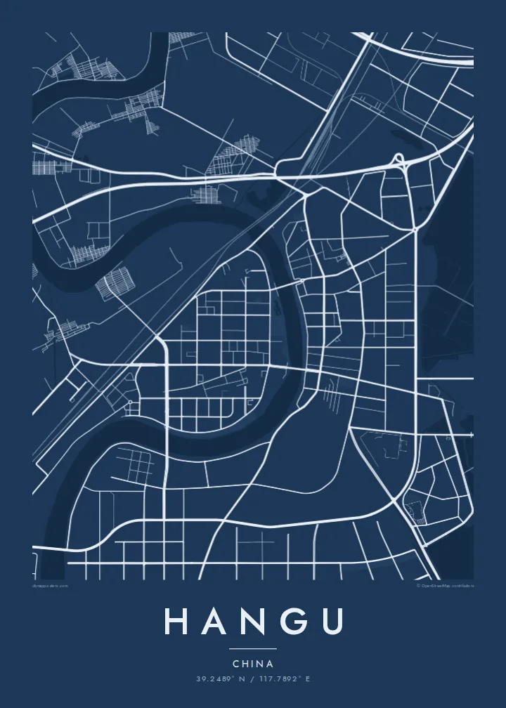
Hangu lies on the northern shore of Bohai Bay, east of central Tianjin, and today forms part of the Binhai New Area. The land here is almost perfectly flat, reclaimed and engineered over generations. From above it reads as a field of straight lines: embankments, drainage channels, roads and the edges of enormous rectangular ponds.
Those ponds belong to the salt works that made Hangu known for centuries. The Changlu salt fields along this coast have long been among the largest sea-salt producers in China. Their evaporation pans create one of the most striking patterns on any map. Between them sit industrial zones and the older town centre on the banks of the Jiyun River.
A Hangu map poster works almost like a technical drawing. Grids of salt pans, straight canals and industrial blocks fill the frame, while the curving river and the coastline supply the only soft lines. It is an unusual subject for a wall, and that is part of its appeal: a place defined by water, flatness and careful human order.
Wide rectangular evaporation ponds stretch along the coast in orderly rows, divided by narrow dikes. On paper they look like a monochrome tiling pattern rather than a landscape.
The river bends through the district towards Bohai Bay. It is one of the few curved lines on the map and a natural anchor for the older part of town.
The coast is largely engineered, with straight seawalls, port basins and reclaimed land, so the edge between land and sea appears sharp and angular rather than natural.
Fai mo oe
Faʻaopoopo se aso, se igoa po o sau lava upu, sui le sitaili, lapoʻa po o le itu.
O le preview e leai se totogi e maualalo le resolution ma iai se watermark. O lolomi ma faila HD e faia i le 300 DPI, e oo atu i le 7,200 × 10,800 px, e aunoa ma se watermark.
Aisea Hangu
People who work in Tianjin's port and industrial zones, or families with roots in the old salt-making town, often want something that shows Hangu as it really looks from above. The geometry suits modern interiors and holds up especially well at larger sizes such as 50×70 cm or 24×36″.
Add a title in your own words, a subtitle and a date, and keep or edit the coordinates line. The Blueprint style brings out the engineered feel, while Sand or Paper soften it. Classic black & white and Noir are also available. Files cost $9, and prints ship from partners in 30+ countries.
Faatau le posita Hangu| Lapoʻa lolomi | Manino | Faila |
|---|---|---|
| 30 × 40 cm11.8 × 15.7″ | 3,543 × 4,724 px | PNG · PDF |
| 29.7 × 42 cm (A3)11.7 × 16.5″ | 3,508 × 4,961 px | PNG · PDF |
| 42 × 59.4 cm (A2)16.5 × 23.4″ | 4,961 × 7,016 px | PNG · PDF |
| 45.7 × 61 cm18 × 24″ | 5,400 × 7,200 px | PNG · PDF |
| 50 × 70 cm19.7 × 27.6″ | 5,906 × 8,268 px | PNG · PDF |
| 61 × 91.4 cm24 × 36″ | 7,200 × 10,800 px | PNG · PDF |
Ae faʻatusatusa, o le faʻataʻitaʻiga e leai se totogi e 900 px le lautele, e iai le faʻailoga vai ma e mo mata. O faila HD e oʻo atu i le 8× le manino i itu taʻitasi ma e lolomi manino i le lapoʻa atoa o le posta.
Filifili se sitaili i le pito i luga o le itulau, ona filifili lea o le Posita Lolomi — se lapopoa ma, afai e te fiafia, se faavaa — po o Faila HD Numera. E na o le tasi laasaga o le Checkout, ma o le a fesuia'i lou itulau o oka i le taimi lava e mae'a ai le totogi.
E lolomiina i luga o pepa matte maualuga le tulaga e 200 gsm, i se tasi o lapopoa e ono, mai le 30 × 40 cm i le 24 × 36″. E amata le tau o posita lolomi mai le $39, aofia ai le auina atu.
Ioe. Filifili se faavaa laau malosi i le lanu uliuli, sina, oak masani, po o le laau pogisa. E aofia ai se tioata e le gau ma ua saunia e tautau i luga. E amata le tau o posita faavaa mai le $99, aofia ai le auina atu.
E leai se totogi o le auina atu i atunuu e 60+. O pepa ata taʻitasi e lolomiina e le tasi o matou paaga lolomi e latalata mai i atunuu e 30+, ma e masani ona taunuu i le 3–7 aso faigaluega. E mafai ona e mulimulitaia le tulaga ma le sailiga i lalo o My Orders. O nisi atunuu e 2–5 vaiaso, ma i nofoaga e lei matou auina atu iai, e taʻu atu e le saite ia te oe a o lei totogi.
Auina mai se ata i totonu o le 14 aso talu ona taunuu, ma o le a matou toe lolomiina e leai se totogi po o le toe faafoi atu lau tupe.
Ioe. I totonu o le editor i lenei itulau, suia le ulutala, le ulutala laititi ma le laina o coordinates i soo se mea e te fiafia i ai, ma filifili se sitaili ma le lapopoa. O oka lolomi, faavaa ma numera e faaaoga uma lava lau mamanu.
Mo le $9 e te maua ai faila PNG 300 DPI ma PDF ua saunia mo le lolomi i lapopoa uma e ono, e aunoa ma se watermark, e mafai ona lolomi i soo se mea. Le mautinoa lava? Download muamua se preview e leai se totogi ma le watermark.
Latalata ane
