Excavated harbour
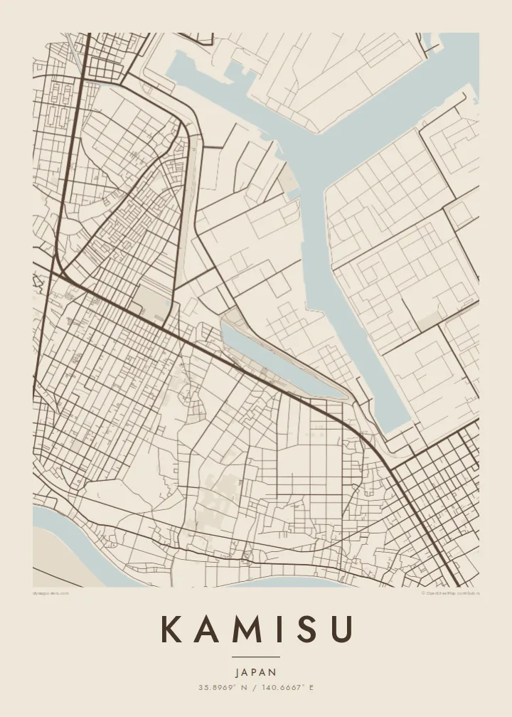
A large port basin was dug into the coast to serve heavy industry. Its straight quays and branching channels make the most striking shape on the map.
Posta faʻafanua faigofie · Japan
35.8969° N / 140.6667° E
A coastal industrial city on the Pacific shore of Ibaraki, set between a long sandy beach, a dug-out port and the lower Tone.


Tasi le aai, lagona e lima
Tapi se sitaili e vaai ai i luga o le puipui. E tutusa uma le tau o sitaili — pe lolomiina, faapipiiina, pe avea ma faila HD.
 Pika Moni · Faila Lolomi 24 × 36″
Manino mo le lolomi
O se vaega atoa (100%) lenei mai le faila lolomi moni. O posita uma — pe lolomiina, faapipiiina pe download mai — e faia i luga o a matou server i le 300 DPI, e oo atu i le 7,200 × 10,800 pika, ina ia manino pea auala laiti i luga o se lolomiga 24 × 36″.
I luga o le puipui


Le faʻafanua
Kamisu occupies the southern part of a long, low strip of land on the eastern edge of Ibaraki. The Pacific lies on one side, and the waterways of the lower Tone River region lie inland. On a map, a straight, unbroken coastline runs along its east. Just inland, a large artificial harbour and industrial zone have been cut into the land.
This is part of the Kashima coastal industrial area, developed in the second half of the twentieth century around an excavated port. Petrochemical plants, steelworks and storage facilities occupy large, regular sites. Residential neighbourhoods, farmland and pine woods fill the remaining ground, and wind turbines stand along parts of the coast.
A Kamisu map poster shows an unusual mix: the clean line of the Pacific shore, the angular basins of the man-made port, the large blocks of industry and the smaller streets of the towns around them. It is a map shaped as much by engineering as by nature.
A large port basin was dug into the coast to serve heavy industry. Its straight quays and branching channels make the most striking shape on the map.
A long, nearly straight sandy coast runs along the eastern side. It sets a clean edge that contrasts with the complex industrial forms inland.
To the west and south, the rivers and wetlands of the lower Tone basin soften the map. They add curving lines against the rectilinear industrial zone.
Fai mo oe
Faʻaopoopo se aso, se igoa po o sau lava upu, sui le sitaili, lapoʻa po o le itu.
O le preview e leai se totogi e maualalo le resolution ma iai se watermark. O lolomi ma faila HD e faia i le 300 DPI, e oo atu i le 7,200 × 10,800 px, e aunoa ma se watermark.
Aisea Kamisu
For people who work in the Kashima industrial zone or grew up along this coast, Kamisu is a place of shifts, sea wind and long straight roads. Its map is bold and geometric, and it makes a strong image.
Personalise the title, subtitle and coordinates line, and choose Classic black & white, Noir, Paper, Blueprint or Sand. The $9 download includes six sizes. Prints come on matte paper with an optional wooden frame.
Faatau le posita Kamisu| Lapoʻa lolomi | Manino | Faila |
|---|---|---|
| 30 × 40 cm11.8 × 15.7″ | 3,543 × 4,724 px | PNG · PDF |
| 29.7 × 42 cm (A3)11.7 × 16.5″ | 3,508 × 4,961 px | PNG · PDF |
| 42 × 59.4 cm (A2)16.5 × 23.4″ | 4,961 × 7,016 px | PNG · PDF |
| 45.7 × 61 cm18 × 24″ | 5,400 × 7,200 px | PNG · PDF |
| 50 × 70 cm19.7 × 27.6″ | 5,906 × 8,268 px | PNG · PDF |
| 61 × 91.4 cm24 × 36″ | 7,200 × 10,800 px | PNG · PDF |
Ae faʻatusatusa, o le faʻataʻitaʻiga e leai se totogi e 900 px le lautele, e iai le faʻailoga vai ma e mo mata. O faila HD e oʻo atu i le 8× le manino i itu taʻitasi ma e lolomi manino i le lapoʻa atoa o le posta.
Filifili se sitaili i le pito i luga o le itulau, ona filifili lea o le Posita Lolomi — se lapopoa ma, afai e te fiafia, se faavaa — po o Faila HD Numera. E na o le tasi laasaga o le Checkout, ma o le a fesuia'i lou itulau o oka i le taimi lava e mae'a ai le totogi.
E lolomiina i luga o pepa matte maualuga le tulaga e 200 gsm, i se tasi o lapopoa e ono, mai le 30 × 40 cm i le 24 × 36″. E amata le tau o posita lolomi mai le $39, aofia ai le auina atu.
Ioe. Filifili se faavaa laau malosi i le lanu uliuli, sina, oak masani, po o le laau pogisa. E aofia ai se tioata e le gau ma ua saunia e tautau i luga. E amata le tau o posita faavaa mai le $99, aofia ai le auina atu.
E leai se totogi o le auina atu i atunuu e 60+. O pepa ata taʻitasi e lolomiina e le tasi o matou paaga lolomi e latalata mai i atunuu e 30+, ma e masani ona taunuu i le 3–7 aso faigaluega. E mafai ona e mulimulitaia le tulaga ma le sailiga i lalo o My Orders. O nisi atunuu e 2–5 vaiaso, ma i nofoaga e lei matou auina atu iai, e taʻu atu e le saite ia te oe a o lei totogi.
Auina mai se ata i totonu o le 14 aso talu ona taunuu, ma o le a matou toe lolomiina e leai se totogi po o le toe faafoi atu lau tupe.
Ioe. I totonu o le editor i lenei itulau, suia le ulutala, le ulutala laititi ma le laina o coordinates i soo se mea e te fiafia i ai, ma filifili se sitaili ma le lapopoa. O oka lolomi, faavaa ma numera e faaaoga uma lava lau mamanu.
Mo le $9 e te maua ai faila PNG 300 DPI ma PDF ua saunia mo le lolomi i lapopoa uma e ono, e aunoa ma se watermark, e mafai ona lolomi i soo se mea. Le mautinoa lava? Download muamua se preview e leai se totogi ma le watermark.
Latalata ane
