The Kaveri
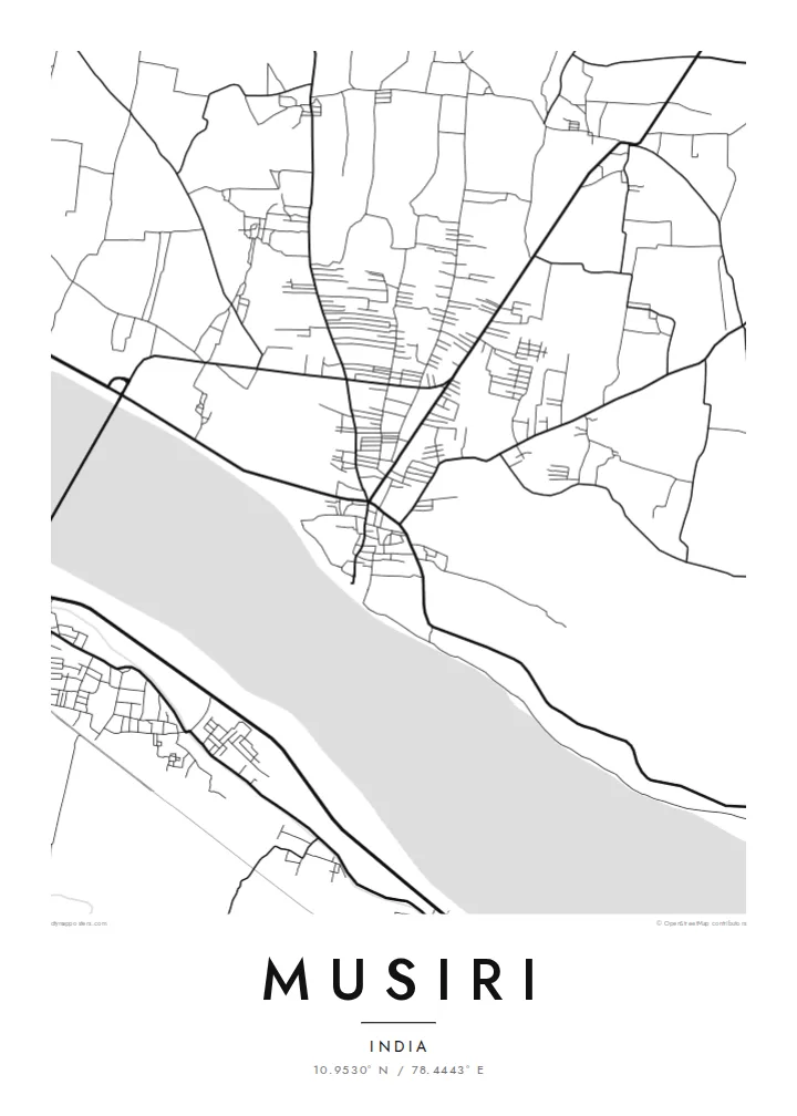
The river runs broad and low past the town, and its channel shifts between water and sand. It forms the southern border of the map and its strongest shape.
Posta faʻafanua faigofie · India
10.9530° N / 78.4443° E
A riverside town on the Kaveri's northern bank, its streets running alongside a wide, braided channel of water and sand.


Tasi le aai, lagona e lima
Tapi se sitaili e vaai ai i luga o le puipui. E tutusa uma le tau o sitaili — pe lolomiina, faapipiiina, pe avea ma faila HD.
 Pika Moni · Faila Lolomi 24 × 36″
Manino mo le lolomi
O se vaega atoa (100%) lenei mai le faila lolomi moni. O posita uma — pe lolomiina, faapipiiina pe download mai — e faia i luga o a matou server i le 300 DPI, e oo atu i le 7,200 × 10,800 pika, ina ia manino pea auala laiti i luga o se lolomiga 24 × 36″.
I luga o le puipui


Le faʻafanua
Musiri is in Tiruchirappalli district, Tamil Nadu, on the northern bank of the Kaveri river upstream from Tiruchirappalli city. The river is the dominant feature of any map of the town. It is a broad band, sometimes full and sometimes braided with sandbars, and it runs roughly east to west along the southern edge of the settlement.
The town itself follows the river, with the main streets roughly parallel to the bank and smaller lanes branching north into farmland. The Kaveri delta and its upstream plains are among the most intensively farmed land in South India, so the map outside the built-up area is largely a pattern of fields, irrigation channels and village roads.
A Musiri map poster suits anyone who knows the town from daily life rather than a guidebook. The composition is simple and strong: a long river, a town strung along its shore, and a quiet farming landscape to the north. In black and white, the river's width and texture give the design its weight.
The river runs broad and low past the town, and its channel shifts between water and sand. It forms the southern border of the map and its strongest shape.
The main roads run parallel to the riverbank, so the town is long and narrow rather than round. That is typical of settlements that grew along the Kaveri.
North of the town, the land becomes a pattern of fields and small channels. Its fine, even texture contrasts with the denser streets near the river.
Fai mo oe
Faʻaopoopo se aso, se igoa po o sau lava upu, sui le sitaili, lapoʻa po o le itu.
O le preview e leai se totogi e maualalo le resolution ma iai se watermark. O lolomi ma faila HD e faia i le 300 DPI, e oo atu i le 7,200 × 10,800 px, e aunoa ma se watermark.
Aisea Musiri
For families from Musiri and the surrounding villages, the Kaveri and the streets beside it are a firm point of reference. A map of the town is a way to keep that riverbank close from a flat in Chennai, Bengaluru or overseas.
The title, subtitle and coordinates line can carry a family name, a date or a short dedication. The map comes in five styles: Classic black and white, Noir, Paper, Blueprint and Sand.
Faatau le posita Musiri| Lapoʻa lolomi | Manino | Faila |
|---|---|---|
| 30 × 40 cm11.8 × 15.7″ | 3,543 × 4,724 px | PNG · PDF |
| 29.7 × 42 cm (A3)11.7 × 16.5″ | 3,508 × 4,961 px | PNG · PDF |
| 42 × 59.4 cm (A2)16.5 × 23.4″ | 4,961 × 7,016 px | PNG · PDF |
| 45.7 × 61 cm18 × 24″ | 5,400 × 7,200 px | PNG · PDF |
| 50 × 70 cm19.7 × 27.6″ | 5,906 × 8,268 px | PNG · PDF |
| 61 × 91.4 cm24 × 36″ | 7,200 × 10,800 px | PNG · PDF |
Ae faʻatusatusa, o le faʻataʻitaʻiga e leai se totogi e 900 px le lautele, e iai le faʻailoga vai ma e mo mata. O faila HD e oʻo atu i le 8× le manino i itu taʻitasi ma e lolomi manino i le lapoʻa atoa o le posta.
Filifili se sitaili i le pito i luga o le itulau, ona filifili lea o le Posita Lolomi — se lapopoa ma, afai e te fiafia, se faavaa — po o Faila HD Numera. E na o le tasi laasaga o le Checkout, ma o le a fesuia'i lou itulau o oka i le taimi lava e mae'a ai le totogi.
E lolomiina i luga o pepa matte maualuga le tulaga e 200 gsm, i se tasi o lapopoa e ono, mai le 30 × 40 cm i le 24 × 36″. E amata le tau o posita lolomi mai le $39, aofia ai le auina atu.
Ioe. Filifili se faavaa laau malosi i le lanu uliuli, sina, oak masani, po o le laau pogisa. E aofia ai se tioata e le gau ma ua saunia e tautau i luga. E amata le tau o posita faavaa mai le $99, aofia ai le auina atu.
E leai se totogi o le auina atu i atunuu e 60+. O pepa ata taʻitasi e lolomiina e le tasi o matou paaga lolomi e latalata mai i atunuu e 30+, ma e masani ona taunuu i le 3–7 aso faigaluega. E mafai ona e mulimulitaia le tulaga ma le sailiga i lalo o My Orders. O nisi atunuu e 2–5 vaiaso, ma i nofoaga e lei matou auina atu iai, e taʻu atu e le saite ia te oe a o lei totogi.
Auina mai se ata i totonu o le 14 aso talu ona taunuu, ma o le a matou toe lolomiina e leai se totogi po o le toe faafoi atu lau tupe.
Ioe. I totonu o le editor i lenei itulau, suia le ulutala, le ulutala laititi ma le laina o coordinates i soo se mea e te fiafia i ai, ma filifili se sitaili ma le lapopoa. O oka lolomi, faavaa ma numera e faaaoga uma lava lau mamanu.
Mo le $9 e te maua ai faila PNG 300 DPI ma PDF ua saunia mo le lolomi i lapopoa uma e ono, e aunoa ma se watermark, e mafai ona lolomi i soo se mea. Le mautinoa lava? Download muamua se preview e leai se totogi ma le watermark.
