Tampa Bypass Canal
This long, straight flood-control channel runs through the area. It is one of the most distinctive lines on the map, clearly engineered rather than natural.
Posta faʻafanua faigofie · United States
27.9239° N / 82.3794° W
A community east of Tampa shaped by the Palm River, the Tampa Bypass Canal and the edge of McKay Bay


Tasi le aai, lagona e lima
Tapi se sitaili e vaai ai i luga o le puipui. E tutusa uma le tau o sitaili — pe lolomiina, faapipiiina, pe avea ma faila HD.
 Pika Moni · Faila Lolomi 24 × 36″
Manino mo le lolomi
O se vaega atoa (100%) lenei mai le faila lolomi moni. O posita uma — pe lolomiina, faapipiiina pe download mai — e faia i luga o a matou server i le 300 DPI, e oo atu i le 7,200 × 10,800 pika, ina ia manino pea auala laiti i luga o se lolomiga 24 × 36″.
I luga o le puipui


Le faʻafanua
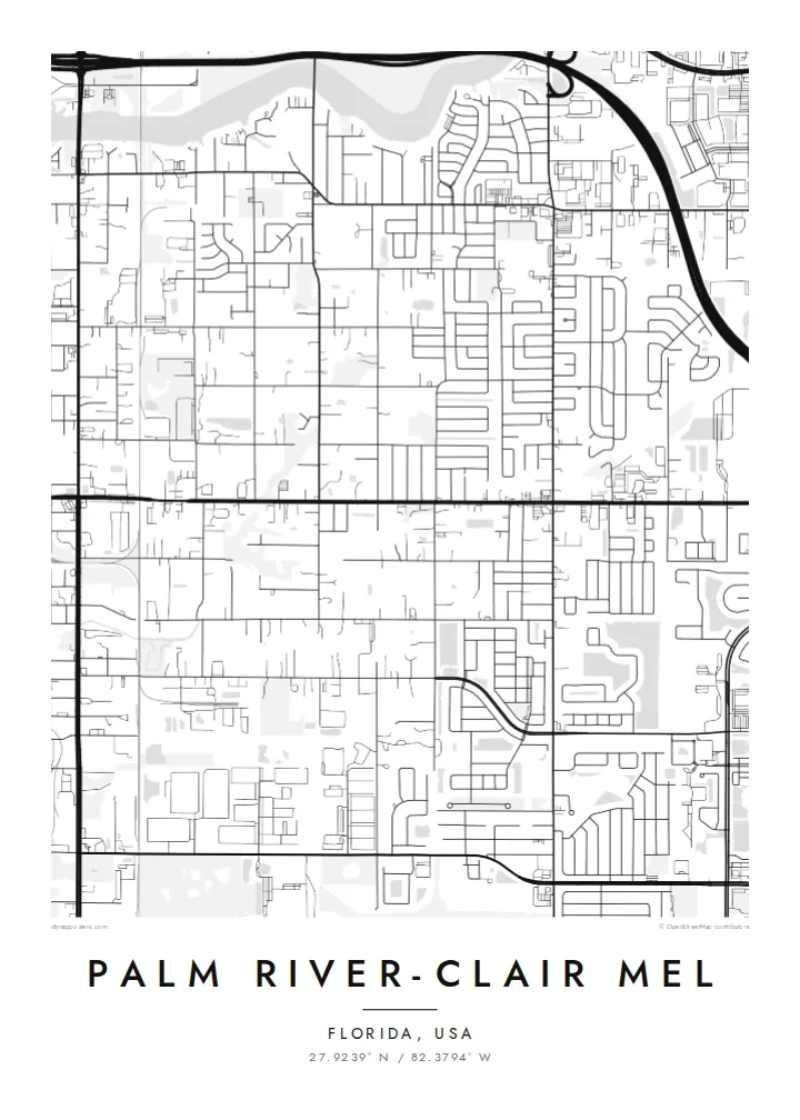
Palm River-Clair Mel is an unincorporated community in Hillsborough County, just east of Tampa. From above, water defines it. The Palm River winds towards McKay Bay, and the straight, man-made Tampa Bypass Canal cuts north to south across the landscape. Between them are residential streets in the familiar Florida pattern of blocks, cul-de-sacs and long arterial roads.
The Tampa Bypass Canal was built as a flood-control channel to protect the city from the overflow of the Hillsborough River. On the map it is one of the clearest features: a long, deliberate line that contrasts with the natural bends of the Palm River. Industrial areas near the port and highways add heavier shapes to the western edge.
A Palm River-Clair Mel map poster captures a place that is often overlooked from the freeway. It shows neighbourhood streets, the meeting of canal, river and bay, and the transition from suburb to waterfront. It is a detailed, specific portrait of an area that residents know well and visitors rarely see as a whole.
This long, straight flood-control channel runs through the area. It is one of the most distinctive lines on the map, clearly engineered rather than natural.
The river takes a winding course towards McKay Bay. Its curves soften the grid of the surrounding streets.
To the west, the land opens onto the waters of McKay Bay near the Port of Tampa, which gives the map a clear coastal edge.
Fai mo oe
Faʻaopoopo se aso, se igoa po o sau lava upu, sui le sitaili, lapoʻa po o le itu.
O le preview e leai se totogi e maualalo le resolution ma iai se watermark. O lolomi ma faila HD e faia i le 300 DPI, e oo atu i le 7,200 × 10,800 px, e aunoa ma se watermark.
Aisea Palm River-Clair Mel
For people who live between the canal and the bay, this map shows their neighbourhood as its own place, not just a corner of Tampa. It makes a good first-home gift or a reminder of a Florida chapter.
Add a custom title, a subtitle such as your street or family name, and the coordinates. Choose Classic black & white, Noir, Paper, Blueprint or Sand. HD files come in six sizes, including 18×24″ and 24×36″, for $9.
Faatau le posita Palm River-Clair Mel| Lapoʻa lolomi | Manino | Faila |
|---|---|---|
| 30 × 40 cm11.8 × 15.7″ | 3,543 × 4,724 px | PNG · PDF |
| 29.7 × 42 cm (A3)11.7 × 16.5″ | 3,508 × 4,961 px | PNG · PDF |
| 42 × 59.4 cm (A2)16.5 × 23.4″ | 4,961 × 7,016 px | PNG · PDF |
| 45.7 × 61 cm18 × 24″ | 5,400 × 7,200 px | PNG · PDF |
| 50 × 70 cm19.7 × 27.6″ | 5,906 × 8,268 px | PNG · PDF |
| 61 × 91.4 cm24 × 36″ | 7,200 × 10,800 px | PNG · PDF |
Ae faʻatusatusa, o le faʻataʻitaʻiga e leai se totogi e 900 px le lautele, e iai le faʻailoga vai ma e mo mata. O faila HD e oʻo atu i le 8× le manino i itu taʻitasi ma e lolomi manino i le lapoʻa atoa o le posta.
Filifili se sitaili i le pito i luga o le itulau, ona filifili lea o le Posita Lolomi — se lapopoa ma, afai e te fiafia, se faavaa — po o Faila HD Numera. E na o le tasi laasaga o le Checkout, ma o le a fesuia'i lou itulau o oka i le taimi lava e mae'a ai le totogi.
E lolomiina i luga o pepa matte maualuga le tulaga e 200 gsm, i se tasi o lapopoa e ono, mai le 30 × 40 cm i le 24 × 36″. E amata le tau o posita lolomi mai le $39, aofia ai le auina atu.
Ioe. Filifili se faavaa laau malosi i le lanu uliuli, sina, oak masani, po o le laau pogisa. E aofia ai se tioata e le gau ma ua saunia e tautau i luga. E amata le tau o posita faavaa mai le $99, aofia ai le auina atu.
E leai se totogi o le auina atu i atunuu e 60+. O pepa ata taʻitasi e lolomiina e le tasi o matou paaga lolomi e latalata mai i atunuu e 30+, ma e masani ona taunuu i le 3–7 aso faigaluega. E mafai ona e mulimulitaia le tulaga ma le sailiga i lalo o My Orders. O nisi atunuu e 2–5 vaiaso, ma i nofoaga e lei matou auina atu iai, e taʻu atu e le saite ia te oe a o lei totogi.
Auina mai se ata i totonu o le 14 aso talu ona taunuu, ma o le a matou toe lolomiina e leai se totogi po o le toe faafoi atu lau tupe.
Ioe. I totonu o le editor i lenei itulau, suia le ulutala, le ulutala laititi ma le laina o coordinates i soo se mea e te fiafia i ai, ma filifili se sitaili ma le lapopoa. O oka lolomi, faavaa ma numera e faaaoga uma lava lau mamanu.
Mo le $9 e te maua ai faila PNG 300 DPI ma PDF ua saunia mo le lolomi i lapopoa uma e ono, e aunoa ma se watermark, e mafai ona lolomi i soo se mea. Le mautinoa lava? Download muamua se preview e leai se totogi ma le watermark.
Latalata ane
