Shimanto River
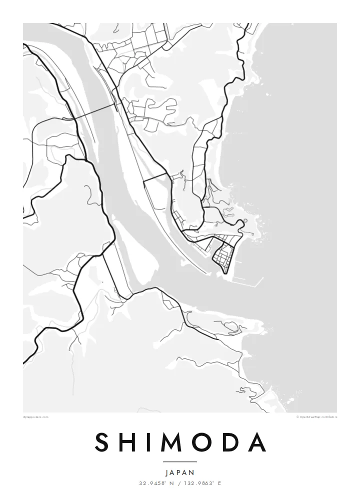
The river's wide, slow bends are the strongest shape on the map, a pale band cutting through the dark mass of the surrounding valley and hills.
Posta faʻafanua faigofie · Japan
32.9458° N / 132.9863° E
A riverside district on Shikoku's southwest, where the broad Shimanto meanders toward the Pacific between wooded ridges and small rice plains.


Tasi le aai, lagona e lima
Tapi se sitaili e vaai ai i luga o le puipui. E tutusa uma le tau o sitaili — pe lolomiina, faapipiiina, pe avea ma faila HD.
 Pika Moni · Faila Lolomi 24 × 36″
Manino mo le lolomi
O se vaega atoa (100%) lenei mai le faila lolomi moni. O posita uma — pe lolomiina, faapipiiina pe download mai — e faia i luga o a matou server i le 300 DPI, e oo atu i le 7,200 × 10,800 pika, ina ia manino pea auala laiti i luga o se lolomiga 24 × 36″.
I luga o le puipui


Le faʻafanua
Shimoda sits in the southwestern corner of Kochi Prefecture on the island of Shikoku, close to where the Shimanto River runs out toward the Pacific. From above, the pattern is simple: a wide ribbon of water, a thin strip of flat land beside it, and steep green ridges pressing in on almost every side, leaving little room for anything like a grid.
The Shimanto is often called the last clear stream in Japan, and it is well known for its low submersible bridges, built without railings so that floods can pass over them. On a map the river dominates everything. The roads follow its banks, the settlements cluster where the valley widens, and the coastline to the south breaks into coves and headlands.
A Shimoda map poster turns this into a composition of curves rather than blocks. The river's sweeping bends carry most of the weight, fine lines of lanes and paths trace the edges of the fields, and the blank hillsides give the drawing a quiet, open feel. It is a map for people who know how this part of Kochi is shaped by water.
The river's wide, slow bends are the strongest shape on the map, a pale band cutting through the dark mass of the surrounding valley and hills.
To the south, the river mouth opens onto the ocean, and the shoreline turns ragged, with small bays and rocky points marking where Shikoku meets open water.
Houses and roads gather on the narrow flat ground beside the river, forming loose clusters instead of a planned street grid and leaving the steep slopes almost empty.
Fai mo oe
Faʻaopoopo se aso, se igoa po o sau lava upu, sui le sitaili, lapoʻa po o le itu.
O le preview e leai se totogi e maualalo le resolution ma iai se watermark. O lolomi ma faila HD e faia i le 300 DPI, e oo atu i le 7,200 × 10,800 px, e aunoa ma se watermark.
Aisea Shimoda
Some people hang Shimoda because they grew up along the Shimanto, and others because they once travelled Shikoku's quiet southwest and remember the river more than any single building. The map keeps the shape of that valley in one clean frame.
Add a title, a date or a line of coordinates, then pick one of five styles. Blueprint suits the river, while Paper or Sand soften the hills. The $9 HD download covers six print sizes, each as a 300 DPI PNG and a print-ready PDF.
Faatau le posita Shimoda| Lapoʻa lolomi | Manino | Faila |
|---|---|---|
| 30 × 40 cm11.8 × 15.7″ | 3,543 × 4,724 px | PNG · PDF |
| 29.7 × 42 cm (A3)11.7 × 16.5″ | 3,508 × 4,961 px | PNG · PDF |
| 42 × 59.4 cm (A2)16.5 × 23.4″ | 4,961 × 7,016 px | PNG · PDF |
| 45.7 × 61 cm18 × 24″ | 5,400 × 7,200 px | PNG · PDF |
| 50 × 70 cm19.7 × 27.6″ | 5,906 × 8,268 px | PNG · PDF |
| 61 × 91.4 cm24 × 36″ | 7,200 × 10,800 px | PNG · PDF |
Ae faʻatusatusa, o le faʻataʻitaʻiga e leai se totogi e 900 px le lautele, e iai le faʻailoga vai ma e mo mata. O faila HD e oʻo atu i le 8× le manino i itu taʻitasi ma e lolomi manino i le lapoʻa atoa o le posta.
Filifili se sitaili i le pito i luga o le itulau, ona filifili lea o le Posita Lolomi — se lapopoa ma, afai e te fiafia, se faavaa — po o Faila HD Numera. E na o le tasi laasaga o le Checkout, ma o le a fesuia'i lou itulau o oka i le taimi lava e mae'a ai le totogi.
E lolomiina i luga o pepa matte maualuga le tulaga e 200 gsm, i se tasi o lapopoa e ono, mai le 30 × 40 cm i le 24 × 36″. E amata le tau o posita lolomi mai le $39, aofia ai le auina atu.
Ioe. Filifili se faavaa laau malosi i le lanu uliuli, sina, oak masani, po o le laau pogisa. E aofia ai se tioata e le gau ma ua saunia e tautau i luga. E amata le tau o posita faavaa mai le $99, aofia ai le auina atu.
E leai se totogi o le auina atu i atunuu e 60+. O pepa ata taʻitasi e lolomiina e le tasi o matou paaga lolomi e latalata mai i atunuu e 30+, ma e masani ona taunuu i le 3–7 aso faigaluega. E mafai ona e mulimulitaia le tulaga ma le sailiga i lalo o My Orders. O nisi atunuu e 2–5 vaiaso, ma i nofoaga e lei matou auina atu iai, e taʻu atu e le saite ia te oe a o lei totogi.
Auina mai se ata i totonu o le 14 aso talu ona taunuu, ma o le a matou toe lolomiina e leai se totogi po o le toe faafoi atu lau tupe.
Ioe. I totonu o le editor i lenei itulau, suia le ulutala, le ulutala laititi ma le laina o coordinates i soo se mea e te fiafia i ai, ma filifili se sitaili ma le lapopoa. O oka lolomi, faavaa ma numera e faaaoga uma lava lau mamanu.
Mo le $9 e te maua ai faila PNG 300 DPI ma PDF ua saunia mo le lolomi i lapopoa uma e ono, e aunoa ma se watermark, e mafai ona lolomi i soo se mea. Le mautinoa lava? Download muamua se preview e leai se totogi ma le watermark.
Latalata ane
