Yuzhong peninsula
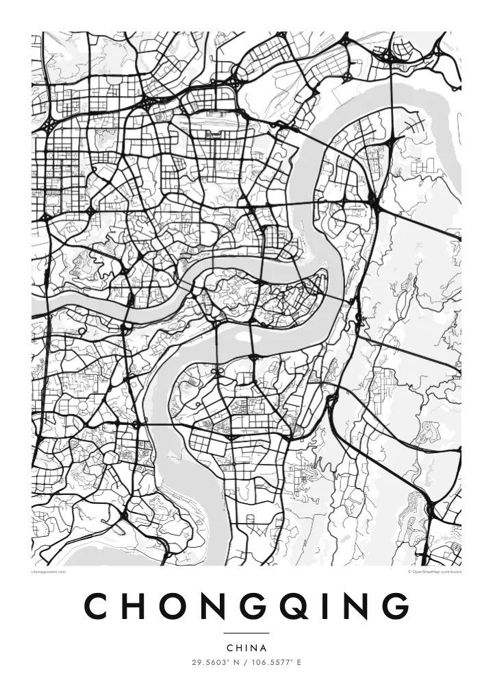
The old centre fills a slender finger of land between the Jialing and Yangtze, ending at Chaotianmen, where the two rivers meet and continue east as one.
Ata mapa faigafua · China
29.5603° N / 106.5577° E
A mountain city folded around the meeting of two rivers, its streets climbing hillsides and bridges stitching every bank together


Kolo e tahi, lanu e nima
Tuki he sitaili ke sio ai ʻi te holo. ʻE tatau pē te totogi ʻo te sitaili fuli pē — mokā tā, fakakātoa, peʻe ko he ʻu faila HD.
 Ngaahi pikiseli moʻoni · faila tā 24 × 36″
Mahino lelei ki te pulūti
Ko he konga 100% ʻo te faila tā moʻoni ʻaeni. Ko te ʻu posita fuli pē — mokā tā, fakakātoa peʻe download — ʻe fakatupu ʻi ʻomātou seva ʻi te 300 DPI, aʻu ki te 7,200 × 10,800 pikiseli, koia ʻe nofo mahino ai te ʻu ala liliki ʻi he tā 24 × 36″.
ʻI Te Puipui


Te mapa
Chongqing is built where the Jialing River flows into the Yangtze, and the map makes that meeting point unmistakable. The historic core of Yuzhong occupies a narrow, rocky peninsula between the two rivers, tapering to a point at Chaotianmen, where the waters join. From there the city spreads across both banks and up into the surrounding ridges, filling valleys and hilltops alike.
Few large cities are this uneven. Streets here do not follow a grid; they curve along contour lines, switch back up slopes and stop abruptly at cliffs, so the pattern on paper looks more like a set of branching veins than a planned plan. Roads sit at different levels, and a building's ground floor on one side may be several storeys up on the other.
A Chongqing map poster turns this terrain into an intricate drawing. Its many bridges, which have earned it the nickname of China's bridge city, cross the Yangtze and Jialing again and again, linking districts that the rivers and hills would otherwise keep apart. The result is one of the most distinctive urban outlines in the world.
The old centre fills a slender finger of land between the Jialing and Yangtze, ending at Chaotianmen, where the two rivers meet and continue east as one.
Roads wind around hills rather than cutting through them, so neighbourhoods appear as curling clusters of streets separated by steep slopes and gaps where the ground falls away.
Dozens of bridges span the two rivers, and on the map they appear as a series of straight lines stitching the curving banks together at regular intervals.
Faʻu ke ʻau ʻa ʻau
Tuku he ʻaho, he hingoa peʻe he kiʻi palalau ʻa ʻau, fetogi te faʻahiga, te lahi peʻe te hake.
Ko te faʻata fua noa ʻe māʻulalo hono lelei pea ʻe ʻi ai he fakaʻilonga. Ko te ʻu tā mo te ʻu faila HD ʻe fakatupu ʻi te 300 DPI, aʻu ki te 7,200 × 10,800 px, ʻe mole ʻi ai he fakaʻilonga.
Koteā ko Chongqing
For anyone who has climbed Chongqing's stairways, ridden the monorail through its hills or looked out over the rivers at night, this map is an unmistakable reminder of the city. It works as a piece for a home there, a keepsake from a trip or a gift for someone who grew up among its slopes.
Add a title and a date that matter to you, and choose from five styles: Classic black & white, Noir, Paper, Blueprint or Sand. The layered streets and river curves read clearly in every version, from dark Noir to warm, soft Sand.
Fakatau te posita Chongqing| Lahi ʻo te pulūti | Mahino | Faile |
|---|---|---|
| 30 × 40 cm11.8 × 15.7″ | 3,543 × 4,724 px | PNG · PDF |
| 29.7 × 42 cm (A3)11.7 × 16.5″ | 3,508 × 4,961 px | PNG · PDF |
| 42 × 59.4 cm (A2)16.5 × 23.4″ | 4,961 × 7,016 px | PNG · PDF |
| 45.7 × 61 cm18 × 24″ | 5,400 × 7,200 px | PNG · PDF |
| 50 × 70 cm19.7 × 27.6″ | 5,906 × 8,268 px | PNG · PDF |
| 61 × 91.4 cm24 × 36″ | 7,200 × 10,800 px | PNG · PDF |
Ko te ata ʻe mole totogi ʻe 900 px tona laulahi, mo te fakaʻilonga, ki te sioʻata pē. Ko te ʻu faile HD ʻe aʻu ki te liuga 8 tona mahino, pea ʻe pulūti lelei ʻi te lahi kātoa.
Fili he sitaili ʻi te tuʻa ʻo te pasina, pea fili leva te Posita Tā — he lahi pea, kapau ʻe ke loto ai, he fakakātoa — peʻe ko te ʻu Faila HD Fakakomipiuta. ʻE tahi pē te sitepu ʻo te totogi, pea ʻe fakafou fakavavevave pē tau pasina fakatau mai te taimi ʻe fai ai te totogi.
ʻE tā ʻi he pepa lelei ʻaupito 200 gsm matte, ʻi he tahi ʻo te ono lahi, mai te 30 × 40 cm ki te 24 × 36″. ʻE kamata te ʻu posita tā ʻi te $39, kātoa mo te ʻave.
ʻIo. Fili he fakakātoa ʻakau moʻoni ʻi te kili, hinahina, ʻakau natula peʻe ʻakau ʻuliʻuli. ʻE ʻi ai mo he sioga mālohi ʻe mole mafesi, pea kua teu ke tautau. ʻE kamata te ʻu posita fakakātoa ʻi te $99, kātoa mo te ʻave.
Ko te fakahoko e mole totogi ki te ʼu fenua e 60+. Ko te pōsita taki taha ʼe tā e te tahi ʼo ʼemau ʼu kaufakalogo tā ʼe ofi mai, ʼi te ʼu fenua e 30+, pea ʼe hoko mai ʼi te ʼu ʼaho gaue e 3–7. ʼE feala hau ke ke vakaʼi te tuʼunga mo te tracking ʼi Oku Fakamaʼu. ʼE ʼi ai te ʼu fenua ʼe 2–5 te ʼu vaiaho, pea ʼi te ʼu fenua ʼaē ʼe heʼeki tou fakahoko ki ai, ʼe fakahā e te saite ʼi muʼa ʼo tau totogi.
Fekau mai he ʻata ʻi loto ʻi te ʻaho e 14 talu mai te aʻu mai, pea mātou toe tā noa peʻe toe totogi atu.
ʻIo. ʻI te meʻa fakatonutonu ʻi te pasina ʻaeni, fetogi te kupu tāfito, te kupu lalo pea mo te laina koʻoliteti ki he meʻa fuli pē ʻe ke loto ai, pea fili he sitaili mo he lahi. Ko te ʻu fakatau tā, fakakātoa mo fakakomipiuta ʻe fakaʻaogaʻi katoa pē tou fakatātā.
Mo te $9 ʻe ke maʻu ai te ʻu faila PNG 300 DPI mo PDF kua teu ke tā, ʻi te ono lahi kātoa, ʻe mole ʻi ai he fakaʻilonga, ke ke tā ai ʻi soʻo he potu. Kei tā fakafiafia? Download muʻa he faʻata mokā mo he fakaʻilonga, ʻe fua noa.
