Neighbourhood clusters
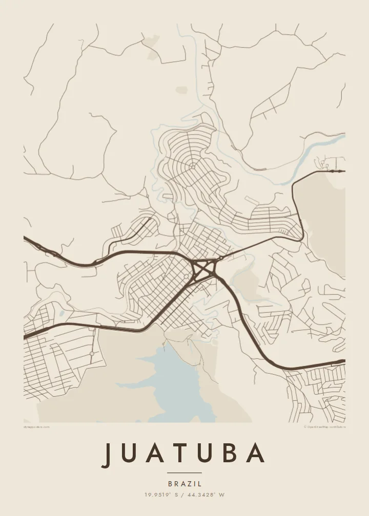
Instead of one dense centre, the map shows several separate groups of streets, each laid out in its own small grid and separated by open, undeveloped ground.
Ata mapa faigafua · Brazil
19.9519° S / 44.3428° W
A young municipality west of Belo Horizonte, where highways and scattered neighbourhoods meet among low green hills.


Kolo e tahi, lanu e nima
Tuki he sitaili ke sio ai ʻi te holo. ʻE tatau pē te totogi ʻo te sitaili fuli pē — mokā tā, fakakātoa, peʻe ko he ʻu faila HD.
 Ngaahi pikiseli moʻoni · faila tā 24 × 36″
Mahino lelei ki te pulūti
Ko he konga 100% ʻo te faila tā moʻoni ʻaeni. Ko te ʻu posita fuli pē — mokā tā, fakakātoa peʻe download — ʻe fakatupu ʻi ʻomātou seva ʻi te 300 DPI, aʻu ki te 7,200 × 10,800 pikiseli, koia ʻe nofo mahino ai te ʻu ala liliki ʻi he tā 24 × 36″.
ʻI Te Puipui


Te mapa
Juatuba is one of the municipalities in the metropolitan region of Belo Horizonte, lying to the west of the state capital in Minas Gerais. It became an independent municipality relatively recently, and its map still shows that: rather than a single historic core, the town is a set of neighbourhoods linked by main roads, each with its own small street grid.
The landscape around it is gently hilly, typical of central Minas Gerais, with pasture, patches of woodland and small streams cutting between the built areas. Highways heading west from the capital pass nearby, and on paper these long strokes contrast with the curving local streets that follow the contours of the land, giving the plan a loose, open rhythm.
A Juatuba map poster captures that spread-out, modern layout: clusters of blocks, green gaps between them and the arteries that tie everything together. For residents it is a precise record of home, and for people who commute into Belo Horizonte it shows the place they return to each evening, reduced to line and space.
Instead of one dense centre, the map shows several separate groups of streets, each laid out in its own small grid and separated by open, undeveloped ground.
Long, straight roads running west from Belo Horizonte cross the area, giving the composition strong lines that frame the smaller residential streets.
Streets bend around low hills and small valleys, and the watercourses between them leave natural gaps that make the layout feel light and open.
Faʻu ke ʻau ʻa ʻau
Tuku he ʻaho, he hingoa peʻe he kiʻi palalau ʻa ʻau, fetogi te faʻahiga, te lahi peʻe te hake.
Ko te faʻata fua noa ʻe māʻulalo hono lelei pea ʻe ʻi ai he fakaʻilonga. Ko te ʻu tā mo te ʻu faila HD ʻe fakatupu ʻi te 300 DPI, aʻu ki te 7,200 × 10,800 px, ʻe mole ʻi ai he fakaʻilonga.
Koteā ko Juatuba
Juatuba has grown as families have settled on the edge of the metropolitan area, and many of them feel a strong attachment to their particular neighbourhood. A map of the town is a straightforward way to mark a first home, a move or a place where children grew up.
The title, subtitle and coordinates line are editable, so the poster can name a street, a family or a year. Choose Classic black & white for a clean look or Sand for a warmer one, and download six print sizes as 300 DPI PNG and PDF files for $9.
Fakatau te posita Juatuba| Lahi ʻo te pulūti | Mahino | Faile |
|---|---|---|
| 30 × 40 cm (11.8 × 15.7″) | 3,543 × 4,724 px | PNG · PDF |
| 29.7 × 42 cm (A3, 11.7 × 16.5″) | 3,508 × 4,961 px | PNG · PDF |
| 42 × 59.4 cm (A2, 16.5 × 23.4″) | 4,961 × 7,016 px | PNG · PDF |
| 45.7 × 61 cm (18 × 24″) | 5,400 × 7,200 px | PNG · PDF |
| 50 × 70 cm (19.7 × 27.6″) | 5,906 × 8,268 px | PNG · PDF |
| 61 × 91.4 cm (24 × 36″) | 7,200 × 10,800 px | PNG · PDF |
Ko te ata ʻe mole totogi ʻe 900 px tona laulahi, mo te fakaʻilonga, ki te sioʻata pē. Ko te ʻu faile HD ʻe aʻu ki te liuga 8 tona mahino, pea ʻe pulūti lelei ʻi te lahi kātoa.
Fili he sitaili ʻi te tuʻa ʻo te pasina, pea fili leva te Posita Tā — he lahi pea, kapau ʻe ke loto ai, he fakakātoa — peʻe ko te ʻu Faila HD Fakakomipiuta. ʻE tahi pē te sitepu ʻo te totogi, pea ʻe fakafou fakavavevave pē tau pasina fakatau mai te taimi ʻe fai ai te totogi.
ʻE tā ʻi he pepa lelei ʻaupito 200 gsm matte, ʻi he tahi ʻo te ono lahi, mai te 30 × 40 cm ki te 24 × 36″. ʻE kamata te ʻu posita tā ʻi te $39, kātoa mo te ʻave.
ʻIo. Fili he fakakātoa ʻakau moʻoni ʻi te kili, hinahina, ʻakau natula peʻe ʻakau ʻuliʻuli. ʻE ʻi ai mo he sioga mālohi ʻe mole mafesi, pea kua teu ke tautau. ʻE kamata te ʻu posita fakakātoa ʻi te $99, kātoa mo te ʻave.
Ko te ʻave ʻe tuʻa totogi ʻi te malamanei katoa. Ko te pōsita ʻe tā e te kaumeʻa tā ʻoku ofi taha ʻi fenua e 30+, pea ʻe aʻu mai ʻi ʻaho gāue e 3–7. ʻE lava ke ke sivi te tuʻunga mo te tulitaki ʻi lalo ʻo Aku ʻōta. ʻE ʻi ai ni fenua ʻe uike e 2–5, pea ʻi te ʻu fenua ʻe mole te ʻave ki ai, ʻe fakahā e te sitē ʻi muʻa ʻo te totogi.
Fekau mai he ʻata ʻi loto ʻi te ʻaho e 14 talu mai te aʻu mai, pea mātou toe tā noa peʻe toe totogi atu.
ʻIo. ʻI te meʻa fakatonutonu ʻi te pasina ʻaeni, fetogi te kupu tāfito, te kupu lalo pea mo te laina koʻoliteti ki he meʻa fuli pē ʻe ke loto ai, pea fili he sitaili mo he lahi. Ko te ʻu fakatau tā, fakakātoa mo fakakomipiuta ʻe fakaʻaogaʻi katoa pē tou fakatātā.
Mo te $9 ʻe ke maʻu ai te ʻu faila PNG 300 DPI mo PDF kua teu ke tā, ʻi te ono lahi kātoa, ʻe mole ʻi ai he fakaʻilonga, ke ke tā ai ʻi soʻo he potu. Kei tā fakafiafia? Download muʻa he faʻata mokā mo he fakaʻilonga, ʻe fua noa.
Ofi
