A refugee-era grid
The neighbourhoods laid out for Asia Minor refugees in the 1920s give Níkaia a tight, regular street pattern that stands apart from the looser, older layouts elsewhere in Attica.
Qeeqabak kaartah poster · Greece
37.9667° N / 23.6500° E
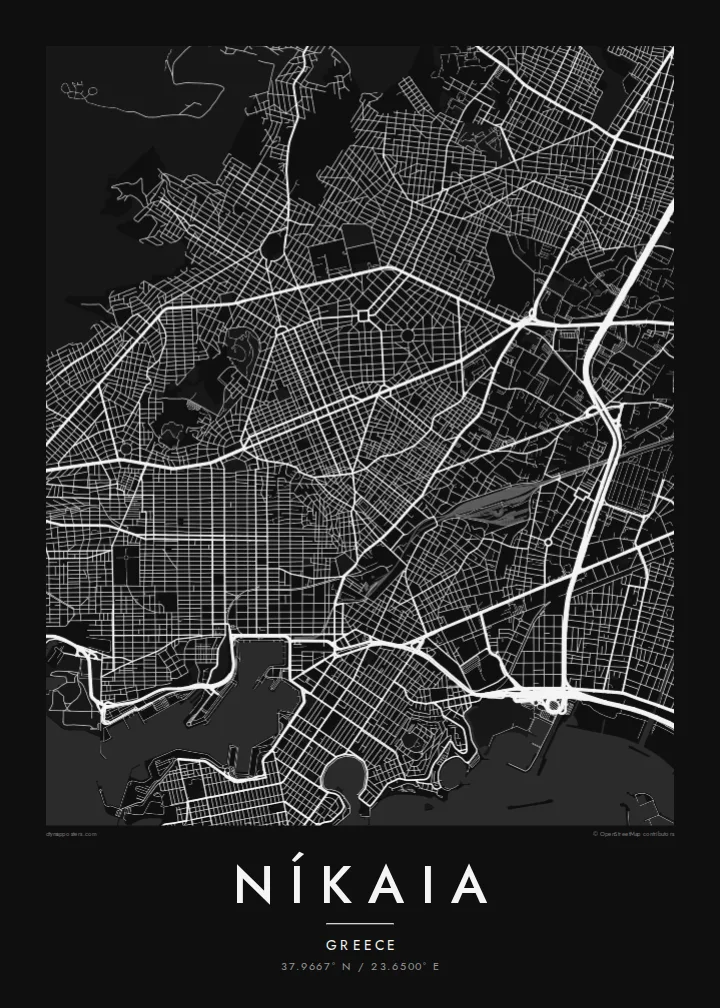
A dense, gridded refugee suburb pressed between Piraeus and the Aigaleo hills, its blocks packed tight against the port city.



Inki magaala, konoy gaba
Qande inkih tibbixeeh derre baguley table. Kulli qande missoowa caagid—daabbisimta, dirbaabu-le kaadu HD fayla akah.
 Cagalah pixels · 24 × 36″ daabbi fayla
Maxxaacah qeeqa
Tama usuk cagalah daabbi faylak 100% qambaala. Kulli poster — daabbisimta, dirbaabu-le kaadu download geytimta — ni-server-ittal 300 DPI-l ederimta, 7,200 × 10,800 pixels fanah, tokkel iyyi ellee catoy 24 × 36″ daabbi baxsi bahisak raaqu.
Gidarih


Kaarta
Níkaia sits just inland of Piraeus, in the western part of the Athens basin. From above it reads as one of the densest pieces of the whole conurbation: short blocks, narrow streets and very few gaps, running uphill from the flat land near the port toward the lower slopes of the Aigaleo range. Its edges with its neighbours are hard to see on the ground, and on a map they vanish entirely.
The town was built in the 1920s by refugees from Asia Minor after 1922, and it takes its name from Nicaea, the Anatolian city now called İznik. That origin still shows in the plan. The streets are more regular than in older Attic towns and were laid out quickly to house a large population, so the grid is tighter and more even than the hillside would suggest.
A Níkaia map poster shows a place defined by density rather than by monuments. The ink is heaviest in the residential core, lighter where arterial roads cut through toward Piraeus and central Athens, and it thins out on the rising ground to the north. It suits anyone with family roots in the Asia Minor diaspora, or anyone who grew up on these crowded, orderly streets.
The neighbourhoods laid out for Asia Minor refugees in the 1920s give Níkaia a tight, regular street pattern that stands apart from the looser, older layouts elsewhere in Attica.
To the south, the town's blocks run straight into Piraeus with no visible break, which makes it clear on paper how closely Níkaia is tied to the port.
Toward the Aigaleo slopes the grid loosens and the streets start to follow the contours, a gentle change in texture you can see across the upper part of the frame.
Kok tanim ab
Ayro, migaq hinnay kok tan xagar osis; gaba, ballaqa hinnay xiqa soorris.
Free preview qansarissi kee watermark-le. Daabbisimtaan kee HD fayla 300 DPI-l, 7,200 × 10,800 px fanah, watermark maleh ederimta.
Macah Níkaia
People hang Níkaia for the story it carries: a town built from nothing by displaced families, named after a city they had left behind. For descendants of those refugees, the map is a quiet record of where a family started over.
You can personalise the title, subtitle and coordinates line, for example with a family name or the year someone arrived, and choose from five styles: Classic black & white, Noir, Paper, Blueprint or Sand. It is available as a $9 HD digital file or as a printed poster.
Níkaia poster orme| Maxxaacah ballaqa | Qeeqa | Faylal |
|---|---|---|
| 30 × 40 cm11.8 × 15.7″ | 3,543 × 4,724 px | PNG · PDF |
| 29.7 × 42 cm (A3)11.7 × 16.5″ | 3,508 × 4,961 px | PNG · PDF |
| 42 × 59.4 cm (A2)16.5 × 23.4″ | 4,961 × 7,016 px | PNG · PDF |
| 45.7 × 61 cm18 × 24″ | 5,400 × 7,200 px | PNG · PDF |
| 50 × 70 cm19.7 × 27.6″ | 5,906 × 8,268 px | PNG · PDF |
| 61 × 91.4 cm24 × 36″ | 7,200 × 10,800 px | PNG · PDF |
Tabbaltah, limo-wayta xaqqa-le ablo 900 px ballaqa le, asta le, iskiriinih keh tan. HD faylal gexsoh inkih addal 8× fanah qeeqa le, poster ballaqa inkih addal meqeh maxxaacimta.
Baxxaqqa qari le qandiy dooriy, tohuk lakal Daabbisimtah Poster — kutuk kee, faxximek, dirbaabu — hinnay HD Digital Fayla dooru. Checkout inki wagitti geytima, kaadu ku-orme page keenih adissa akke waqdi caagoy kummite.
Usuk 200 gsm-le catam kutuk warqatal, lica katiy caagitte $39-ik hane ayta 30 × 40 cm-ik 24 × 36″ fanah, xaagu keenil warreeh.
Ee. Sarrah-le dirbaabu doori — bad, gudduc, oak-le hinnay bad-madabuy. Usuk finqisiimam ellee sange qarab-le kaadu qari umukku iyya keenih taagu. Dirbaabu-le poster $99-ik hane, xaagu keenil warreeh.
Dirsa 60+ baaxoh bilsa. Poster kasa 30+ baaxoh nel print kaadu yan kee dirgeh kaxxa kee tanah printa, kee 3–7 xaqu ayyaamah yaaxigeeh. Xaaloo kee tracking "Ac Order" gexsitam. Kaadu baaxo 2–5 isbuuc yaaxigeeh, nanu dirsi yanin baaxoh sajiitah site ku kalah tekkeh.
Geytimeek 14 ayróy addal foto naah rubbaay, cisab-le daabbisiynah hinnay ku-lacay gacisnaah.
Ee. Tama page-l edito addal, migaaq, subtitle kee coordinates sarrah faxxem fanah badal, kaadu qande kee katiy doori. Daabbisimtah, dirbaabu-le kaadu digital orme inkih ku-design cagalah yekkelen.
$9 bacisak 300 DPI PNG kee daabbisimtah adissime PDF fayla lica katiy inkih, watermark maleh, ayyi meki daabbisimtah geeytitta. Cisab makkoysemty ana? Awqak, watermark-le free preview download-eh.
Xayyo
