Stepped hillside
Streets switch back and forth up the steep slopes behind the bay, producing a dense, looping pattern that thins out as the land rises toward the mountains.
Minimalist map poster · Japan
35.0883° N / 139.0532° E
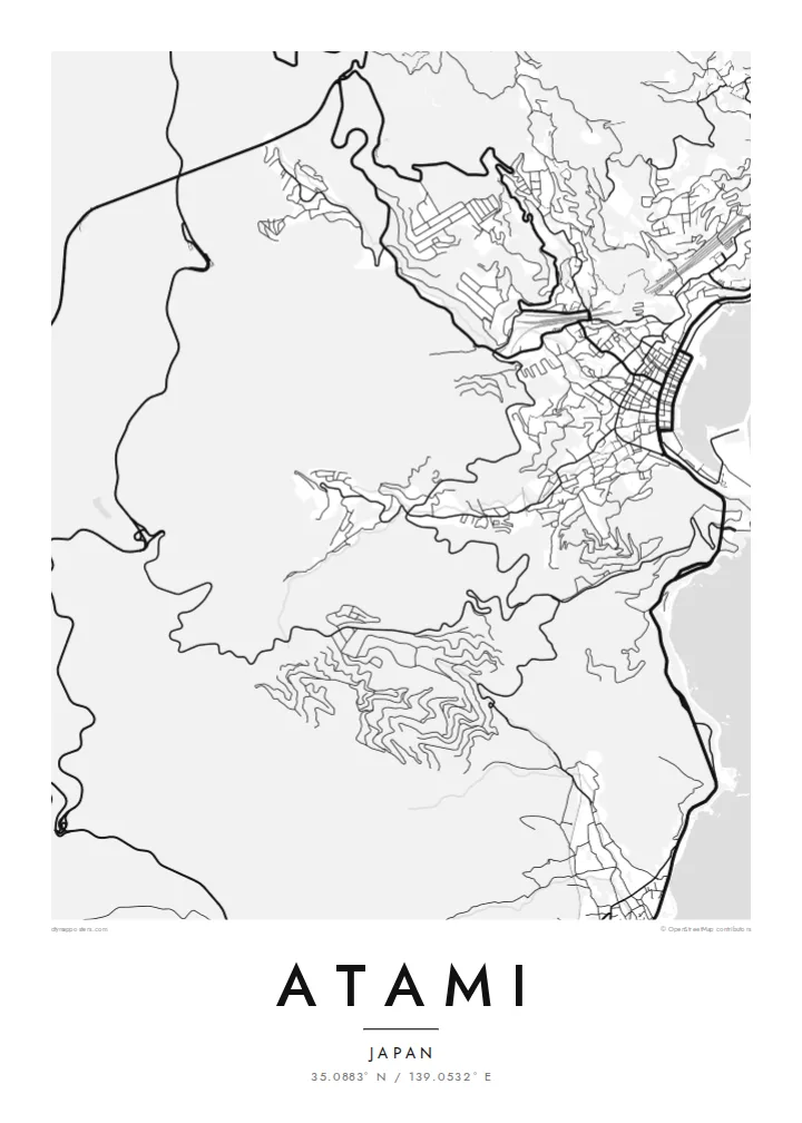
A hot-spring town climbing steep slopes above Sagami Bay, its streets twisting between hillsides, the shoreline and a small curved harbour.
One city, five moods
Tap a style to see it on the wall. Every style costs the same — printed, framed or as HD files.
 Actual pixels · 24 × 36″ print file
Print-sharp
This is a 100% crop of the real print file. Every poster — printed, framed or downloaded — is rendered on our servers at 300 DPI, up to 7,200 × 10,800 pixels, so even the smallest lanes stay crisp on a 24 × 36″ print.
On the wall


The map
Atami sits at the northern edge of the Izu Peninsula, where the mountains drop almost straight into Sagami Bay. There is little flat land, so the town rises in layers up the slopes, with streets zigzagging to reach hotels, homes and viewpoints. From above, the plan is dense near the water and increasingly fragmented as it climbs the hillside.
The town has been known for its hot springs for centuries and became a popular resort in the modern era, helped by the Tokaido Shinkansen, which stops here on the way between Tokyo and western Japan. On an Atami map poster, the rail line and tunnels cut through the hills in firm straight lines against the tangled local streets.
Along the waterfront, a narrow strip of promenade, beach and harbour faces the bay, and the coastline curves around toward neighbouring inlets. Offshore, small islands sit in the water beyond the harbour. The combination of steep terrain, winding streets and open sea gives Atami one of the most sculptural outlines of any Japanese coastal town.
Streets switch back and forth up the steep slopes behind the bay, producing a dense, looping pattern that thins out as the land rises toward the mountains.
The high-speed rail line passes through the town in tunnels and cuttings, drawing a strong, straight line across the irregular hillside street pattern.
A short curved waterfront, beach and harbour face Sagami Bay, giving the map a clean coastal edge against the open water.
Make it yours
Add a date, a name or a line of your own, switch style, size or orientation.
The free preview is low-resolution with a watermark. Prints and HD files are rendered at 300 DPI, up to 7,200 × 10,800 px, without a watermark.
Why Atami
Atami is a place of holidays, family trips and quiet weekends by the sea. A map of its steep streets and curved bay makes a fitting keepsake for anyone who has stayed there or has ties to the Izu coast.
The title and subtitle can be changed to a name, a hotel, a date or a short phrase, in English or Japanese. Blueprint emphasises the sea, while Noir makes the dense hillside streets stand out sharply.
Order the Atami poster| Print size | Resolution | Files |
|---|---|---|
| 30 × 40 cm11.8 × 15.7″ | 3,543 × 4,724 px | PNG · PDF |
| 29.7 × 42 cm (A3)11.7 × 16.5″ | 3,508 × 4,961 px | PNG · PDF |
| 42 × 59.4 cm (A2)16.5 × 23.4″ | 4,961 × 7,016 px | PNG · PDF |
| 45.7 × 61 cm18 × 24″ | 5,400 × 7,200 px | PNG · PDF |
| 50 × 70 cm19.7 × 27.6″ | 5,906 × 8,268 px | PNG · PDF |
| 61 × 91.4 cm24 × 36″ | 7,200 × 10,800 px | PNG · PDF |
For comparison, the free preview is 900 px wide, watermarked and meant for screens. The HD files have up to 8× the resolution in each direction and print cleanly at full poster size.
Pick a style at the top of the page, then choose Printed Poster — a size and, if you like, a frame — or Digital HD Files. Checkout takes one step, and your order page updates as soon as the payment goes through.
It is printed on premium 200 gsm matte paper in one of six sizes, from 30 × 40 cm to 24 × 36″. Printed posters start at $39, shipping included.
Yes. Choose a solid wood frame in black, white, natural oak or dark wood. It comes with shatterproof glazing and is ready to hang. Framed posters start at $99, shipping included.
Shipping is free to 60+ countries. Each poster is printed by the nearest of our print partners in 30+ countries and usually arrives in 3–7 business days. You can follow the status and tracking under My Orders. A few countries take 2–5 weeks, and where we don't ship yet, the site tells you before you pay.
Send us a photo within 14 days of delivery and we will reprint it for free or refund you.
Yes. In the editor on this page, change the title, the subtitle and the coordinates line to anything you like, and pick a style and size. Printed, framed and digital orders all use exactly your design.
For $9 you get 300 DPI PNG and print-ready PDF files in all six sizes, without a watermark, to print anywhere. Not sure yet? Download a free watermarked preview first.
Nearby
