Connaught Place
A circular commercial centre built as concentric rings of colonnaded buildings, with roads radiating outward. It is one of the most recognisable geometric shapes in the city.
Minimalist map poster · India
28.6519° N / 77.2315° E
A river city of layered capitals, from the walled lanes of Shahjahanabad to the radial avenues of New Delhi
One city, five moods
Tap a style to see it on the wall. Every style costs the same — printed, framed or as HD files.
 Actual pixels · 24 × 36″ print file
Print-sharp
This is a 100% crop of the real print file. Every poster — printed, framed or downloaded — is rendered on our servers at 300 DPI, up to 7,200 × 10,800 pixels, so even the smallest lanes stay crisp on a 24 × 36″ print.
On the wall


The map
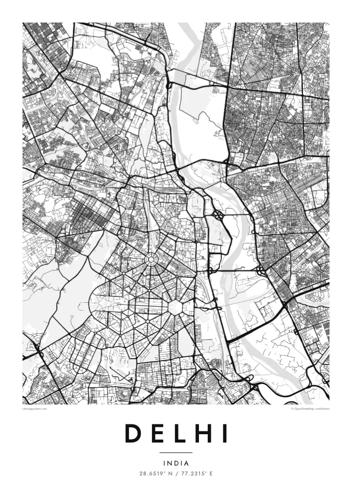
Delhi spreads mainly along the western bank of the Yamuna River, with the forested Ridge, an old extension of the Aravalli hills, running through it from north to south. The city is built in layers, each capital placed beside the last, so the map shows distinct patterns side by side: medieval ruins to the south, the Mughal walled city to the north, and the ordered avenues of New Delhi in between.
Shahjahanabad, now Old Delhi, is a dense web of lanes around the Red Fort and the Jama Masjid, with Chandni Chowk running straight through it. To the south, New Delhi was laid out in the 1910s and 1920s with broad tree-lined avenues, roundabouts and hexagonal blocks. Connaught Place forms a set of concentric circles, and Kartavya Path runs east from Rashtrapati Bhavan to India Gate.
Three UNESCO World Heritage Sites lie within the city: the Red Fort Complex, Humayun’s Tomb and the Qutb Minar with its monuments. A Delhi map poster brings together the contrasts between these eras, the organic lanes of Old Delhi and the formal geometry of the colonial capital, framed by the Ring Road and the Yamuna.
A circular commercial centre built as concentric rings of colonnaded buildings, with roads radiating outward. It is one of the most recognisable geometric shapes in the city.
The ceremonial avenue, formerly Rajpath, runs in a straight line between Rashtrapati Bhavan and India Gate, flanked by lawns and water channels, forming the central axis of New Delhi.
Around the Red Fort and Chandni Chowk, a tight network of lanes and bazaars fills the former walled city, creating the finest, densest texture anywhere on the map.
Make it yours
Add a date, a name or a line of your own, switch style, size or orientation.
The free preview is low-resolution with a watermark. Prints and HD files are rendered at 300 DPI, up to 7,200 × 10,800 px, without a watermark.
Why Delhi
Delhi is a city of neighbourhoods and memories: a family house in Old Delhi, college years on the North Campus, a first flat somewhere in the south. A map poster keeps those places in one frame and shows how they connect.
Title it Delhi, New Delhi or the name of your colony, and add a subtitle with a date or a message. Edit the coordinates line as you like, and choose from Classic black & white, Noir, Paper, Blueprint and Sand in any of six print sizes.
Order the Delhi poster| Print size | Resolution | Files |
|---|---|---|
| 30 × 40 cm11.8 × 15.7″ | 3,543 × 4,724 px | PNG · PDF |
| 29.7 × 42 cm (A3)11.7 × 16.5″ | 3,508 × 4,961 px | PNG · PDF |
| 42 × 59.4 cm (A2)16.5 × 23.4″ | 4,961 × 7,016 px | PNG · PDF |
| 45.7 × 61 cm18 × 24″ | 5,400 × 7,200 px | PNG · PDF |
| 50 × 70 cm19.7 × 27.6″ | 5,906 × 8,268 px | PNG · PDF |
| 61 × 91.4 cm24 × 36″ | 7,200 × 10,800 px | PNG · PDF |
For comparison, the free preview is 900 px wide, watermarked and meant for screens. The HD files have up to 8× the resolution in each direction and print cleanly at full poster size.
Pick a style at the top of the page, then choose Printed Poster — a size and, if you like, a frame — or Digital HD Files. Checkout takes one step, and your order page updates as soon as the payment goes through.
It is printed on premium 200 gsm matte paper in one of six sizes, from 30 × 40 cm to 24 × 36″. Printed posters start at $39, shipping included.
Yes. Choose a solid wood frame in black, white, natural oak or dark wood. It comes with shatterproof glazing and is ready to hang. Framed posters start at $99, shipping included.
Shipping is free to 60+ countries. Each poster is printed by the nearest of our print partners in 30+ countries and usually arrives in 3–7 business days. You can follow the status and tracking under My Orders. A few countries take 2–5 weeks, and where we don't ship yet, the site tells you before you pay.
Send us a photo within 14 days of delivery and we will reprint it for free or refund you.
Yes. In the editor on this page, change the title, the subtitle and the coordinates line to anything you like, and pick a style and size. Printed, framed and digital orders all use exactly your design.
For $9 you get 300 DPI PNG and print-ready PDF files in all six sizes, without a watermark, to print anywhere. Not sure yet? Download a free watermarked preview first.
Nearby
