Ginza grid
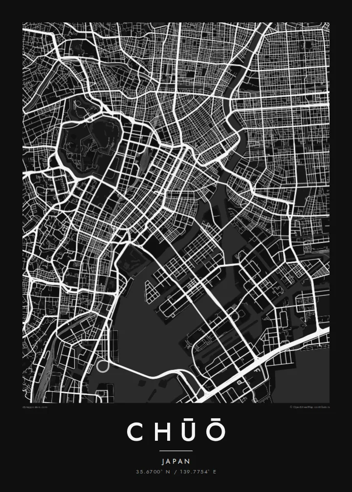
Ginza's regular blocks and main avenues form one of the most orderly street patterns in Tokyo. On the map it sits between former canal routes.
Póster de mapa minimalista · Japón
35.6700° N / 139.7754° E
Tokyo's historic commercial heart between the Imperial moats and the Sumida, extending onto reclaimed islands in the bay



Una ciudad, cinco ambientes
Toca un estilo para verlo en la pared. Todos los estilos cuestan lo mismo: impreso, enmarcado o en archivos HD.
 Píxeles reales · archivo de impresión de 24 × 36″
Nitidez de impresión
Este es un recorte al 100% del archivo de impresión real. Cada póster —impreso, enmarcado o descargado— se renderiza en nuestros servidores a 300 DPI, hasta 7,200 × 10,800 píxeles, para que hasta las calles más pequeñas se vean nítidas en una impresión de 24 × 36″.
En la pared


El mapa
Chūō is one of Tokyo's central wards, lying between the area around the Imperial Palace and Tokyo Bay. It includes Nihonbashi, the old merchant district, and Ginza, famous for department stores and shopping. In the Edo period, the Nihonbashi bridge was the starting point of the main roads out of the city, and road distances in Japan are still measured from a marker there.
The ward's map is shaped by water. The Sumida River runs along its eastern side, and canals and old moats once surrounded the commercial districts. Some of these are now covered by expressways. To the southeast, the islands of Tsukishima, Kachidoki and Harumi were built on reclaimed land in the bay and are now filled with apartment towers.
A Chūō map poster shows the tight grid of Ginza and Nihonbashi, the wide Sumida, and the geometric outlines of the reclaimed islands. Few parts of Tokyo show so clearly how the city has grown out into the water. It makes a precise and detailed print for anyone who has worked, shopped or lived in the centre of Tokyo.
Ginza's regular blocks and main avenues form one of the most orderly street patterns in Tokyo. On the map it sits between former canal routes.
The old merchant district around the famous bridge, which served as the Edo-period starting point for the main roads leading out of the city.
Tsukishima, Kachidoki and Harumi extend into Tokyo Bay as angular blocks of reclaimed land, connected to the rest of the city by long bridges.
Hazlo tuyo
Añade una fecha, un nombre o una frase propia, y cambia el estilo, el tamaño o la orientación.
La vista previa gratuita es de baja resolución y con marca de agua. Las impresiones y los archivos HD se renderizan a 300 DPI, hasta 7,200 × 10,800 px, sin marca de agua.
Por qué Chūō
For many people, Chūō is the part of Tokyo where they worked, stayed or walked on their first visit. The map puts Ginza, Nihonbashi and the Sumida together in one clear view.
You can personalise the title, subtitle and coordinates, for example with an office address or the year of a trip. Choose one of five styles: Classic black & white, Noir, Paper, Blueprint or Sand. Noir suits the dense grid especially well.
Pedir el póster Chūō| Tamaño de impresión | Resolución | Archivos |
|---|---|---|
| 30 × 40 cm (11.8 × 15.7″) | 3,543 × 4,724 px | PNG · PDF |
| 29.7 × 42 cm (A3, 11.7 × 16.5″) | 3,508 × 4,961 px | PNG · PDF |
| 42 × 59.4 cm (A2, 16.5 × 23.4″) | 4,961 × 7,016 px | PNG · PDF |
| 45.7 × 61 cm (18 × 24″) | 5,400 × 7,200 px | PNG · PDF |
| 50 × 70 cm (19.7 × 27.6″) | 5,906 × 8,268 px | PNG · PDF |
| 61 × 91.4 cm (24 × 36″) | 7,200 × 10,800 px | PNG · PDF |
Como referencia, la vista previa gratuita mide 900 px de ancho, lleva marca de agua y está pensada para pantallas. Los archivos HD tienen hasta 8 veces más resolución en cada dirección y se imprimen con total nitidez a tamaño póster.
Elige un estilo arriba de la página y luego selecciona Póster Impreso —un tamaño y, si quieres, un marco— o Archivos Digitales HD. El pago se hace en un solo paso, y tu página de pedido se actualiza en cuanto se confirma el pago.
Se imprime en papel mate premium de 200 g/m² en uno de seis tamaños, desde 30 × 40 cm hasta 24 × 36″. Los pósters impresos cuestan desde {printFrom}, envío incluido.
Sí. Elige un marco de madera maciza en negro, blanco, roble natural o madera oscura. Incluye vidrio irrompible y llega listo para colgar. Los pósters enmarcados cuestan desde {framedFrom}, envío incluido.
El envío es gratis en todo el mundo. Cada póster lo imprime el socio de impresión más cercano entre más de 30 países y suele llegar en 3 a 7 días hábiles. Puedes seguir el estado y el seguimiento en Mis Pedidos.
Envíanos una foto dentro de los 14 días posteriores a la entrega y te lo reimprimimos gratis o te devolvemos el dinero.
Sí. En el editor de esta página, cambia el título, el subtítulo y la línea de coordenadas por lo que quieras, y elige un estilo y un tamaño. Los pedidos impresos, enmarcados y digitales usan exactamente tu diseño.
Por $9 obtienes archivos PNG a 300 DPI y PDF listos para imprimir en los seis tamaños, sin marca de agua, para imprimir donde quieras. ¿Aún no estás seguro? Descarga primero una vista previa gratis con marca de agua.
