Würm valley
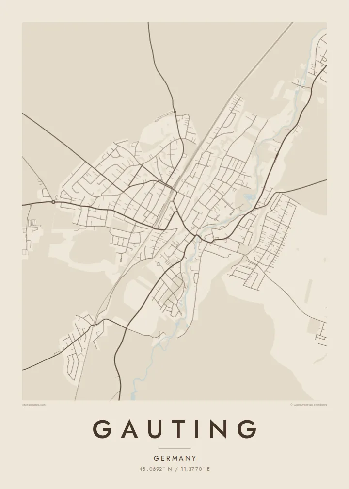
The river winds through the centre of town, flowing north from Lake Starnberg toward Munich, and sets the orientation of the whole map.
Póster de mapa minimalista · Alemania
48.0692° N / 11.3770° E
A town strung along the wooded Würm valley between Munich and Lake Starnberg, with forest on the plateaus above.


Una ciudad, cinco ambientes
Toca un estilo para verlo en la pared. Todos los estilos cuestan lo mismo: impreso, enmarcado o en archivos HD.
 Píxeles reales · archivo de impresión de 24 × 36″
Nitidez de impresión
Este es un recorte al 100% del archivo de impresión real. Cada póster —impreso, enmarcado o descargado— se renderiza en nuestros servidores a 300 DPI, hasta 7,200 × 10,800 píxeles, para que hasta las calles más pequeñas se vean nítidas en una impresión de 24 × 36″.
En la pared


El mapa
Gauting lies southwest of Munich in the district of Starnberg, following the course of the Würm, the river that flows out of Lake Starnberg. From above, the town is long and relatively narrow, its centre in the valley and residential streets climbing onto the higher ground on either side, where large forests begin.
The S-Bahn line from Munich runs through the valley, making Gauting a place where many live within reach of the city while surrounded by woodland. Local tradition holds that Charlemagne was born at the Reismühle, a mill on the Würm here, though historians treat this as legend rather than fact.
A Gauting map poster captures this linear layout. The Würm snakes through the centre, the railway runs close beside it, and the forest areas to the east and west remain open and quiet on the map. It is a composition shaped by river and woodland, with suburbs threaded carefully between them.
The river winds through the centre of town, flowing north from Lake Starnberg toward Munich, and sets the orientation of the whole map.
The railway follows the valley alongside the river, a clean straight line connecting Gauting to Munich and Starnberg.
Large forested areas cover the plateaus beside the valley, leaving broad open spaces that frame the settled strip along the Würm.
Hazlo tuyo
Añade una fecha, un nombre o una frase propia, y cambia el estilo, el tamaño o la orientación.
La vista previa gratuita es de baja resolución y con marca de agua. Las impresiones y los archivos HD se renderizan a 300 DPI, hasta 7,200 × 10,800 px, sin marca de agua.
Por qué Gauting
Gauting is a thoughtful choice for families who moved out of Munich for more space, or anyone who knows its forest paths and riverbanks. The valley shape makes a gentle, elegant print.
Personalise the title, subtitle and coordinates to mark a home or a milestone. Choose Classic black & white, Noir, Paper, Blueprint or Sand, and order HD files in six sizes or a matte print with an optional wooden frame.
Pedir el póster Gauting| Tamaño de impresión | Resolución | Archivos |
|---|---|---|
| 30 × 40 cm (11.8 × 15.7″) | 3,543 × 4,724 px | PNG · PDF |
| 29.7 × 42 cm (A3, 11.7 × 16.5″) | 3,508 × 4,961 px | PNG · PDF |
| 42 × 59.4 cm (A2, 16.5 × 23.4″) | 4,961 × 7,016 px | PNG · PDF |
| 45.7 × 61 cm (18 × 24″) | 5,400 × 7,200 px | PNG · PDF |
| 50 × 70 cm (19.7 × 27.6″) | 5,906 × 8,268 px | PNG · PDF |
| 61 × 91.4 cm (24 × 36″) | 7,200 × 10,800 px | PNG · PDF |
Como referencia, la vista previa gratuita mide 900 px de ancho, lleva marca de agua y está pensada para pantallas. Los archivos HD tienen hasta 8 veces más resolución en cada dirección y se imprimen con total nitidez a tamaño póster.
Elige un estilo arriba de la página y luego selecciona Póster Impreso —un tamaño y, si quieres, un marco— o Archivos Digitales HD. El pago se hace en un solo paso, y tu página de pedido se actualiza en cuanto se confirma el pago.
Se imprime en papel mate premium de 200 g/m² en uno de seis tamaños, desde 30 × 40 cm hasta 24 × 36″. Los pósters impresos cuestan desde $39, envío incluido.
Sí. Elige un marco de madera maciza en negro, blanco, roble natural o madera oscura. Incluye vidrio irrompible y llega listo para colgar. Los pósters enmarcados cuestan desde $99, envío incluido.
El envío es gratuito a todo el mundo. Cada póster lo imprime el socio de impresión más cercano de nuestra red, presente en más de 30 países, y suele llegar en 3–7 días hábiles. Puedes seguir el estado y el seguimiento en Mis pedidos. En algunos países tarda de 2 a 5 semanas y, si todavía no enviamos a tu país, el sitio te lo avisa antes de pagar.
Envíanos una foto dentro de los 14 días posteriores a la entrega y te lo reimprimimos gratis o te devolvemos el dinero.
Sí. En el editor de esta página, cambia el título, el subtítulo y la línea de coordenadas por lo que quieras, y elige un estilo y un tamaño. Los pedidos impresos, enmarcados y digitales usan exactamente tu diseño.
Por $9 obtienes archivos PNG a 300 DPI y PDF listos para imprimir en los seis tamaños, sin marca de agua, para imprimir donde quieras. ¿Aún no estás seguro? Descarga primero una vista previa gratis con marca de agua.
Cerca
