Nakasu island
The Naka River divides around a long, narrow island between Hakata and Tenjin. The island is lined with streets and bridges and known for its evening food stalls.
Minimalist map poster · Japan
33.6000° N / 130.4167° E
A bay-side city where two historic towns meet across the Naka River, with the airport minutes from the centre.
One city, five moods
Tap a style to see it on the wall. Every style costs the same — printed, framed or as HD files.
 Actual pixels · 24 × 36″ print file
Print-sharp
This is a 100% crop of the real print file. Every poster — printed, framed or downloaded — is rendered on our servers at 300 DPI, up to 7,200 × 10,800 pixels, so even the smallest lanes stay crisp on a 24 × 36″ print.
On the wall


The map
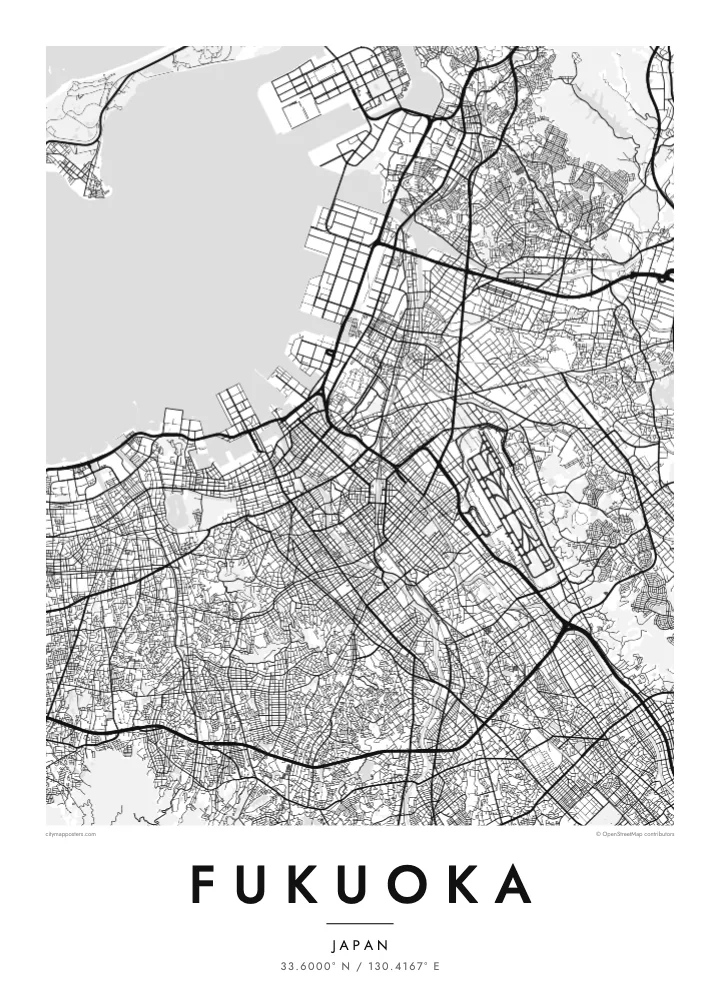
Fukuoka lies on Hakata Bay in northern Kyushu, and its map still reflects the two towns it grew from. East of the Naka River was Hakata, the old merchant port. West of it was Fukuoka, the castle town of the Kuroda lords. Between them the river splits around Nakasu, a narrow island of streets that is now one of the city's nightlife districts.
West of the river, the moats and stone walls of the Fukuoka Castle ruins stand next to Ohori Park. The park's large lake, with its string of islands, is one of the clearest shapes on the map. Tenjin, the main shopping district, lies between the castle and the river. To the east, Hakata Station and the old temple quarter mark the other historic centre.
Fukuoka Airport sits unusually close to the city centre, and its runway appears as a long straight shape just east of Hakata. A Fukuoka map poster fits bay, river, island, castle and lake into one compact frame. The yatai food stalls along the Nakasu riverbank are one reason the city stays in so many people's memories.
The Naka River divides around a long, narrow island between Hakata and Tenjin. The island is lined with streets and bridges and known for its evening food stalls.
A large lake that was once part of the castle moat sits in the west of the city. Its islands are linked by bridges across the middle, making an unmistakable shape on the poster.
The bay curves along the northern edge of the city. Port piers and reclaimed land give the calm water a sharp, angular shoreline.
Make it yours
Add a date, a name or a line of your own, switch style, size or orientation.
The free preview is low-resolution with a watermark. Prints and HD files are rendered at 300 DPI, up to 7,200 × 10,800 px, without a watermark.
Why Fukuoka
Fukuoka is where many people spent their student years or a first posting abroad, and its compact centre makes a map feel personal. Name the poster after a ward or station, add a date as the subtitle, and set the coordinates.
Paper gives the bay and lake a calm, understated look, and Noir shows the river as light lines on black. The $9 download covers six sizes as PNG and PDF, and a free 900 px preview lets you check the design before you buy.
Order the Fukuoka poster| Print size | Resolution | Files |
|---|---|---|
| 30 × 40 cm11.8 × 15.7″ | 3,543 × 4,724 px | PNG · PDF |
| 29.7 × 42 cm (A3)11.7 × 16.5″ | 3,508 × 4,961 px | PNG · PDF |
| 42 × 59.4 cm (A2)16.5 × 23.4″ | 4,961 × 7,016 px | PNG · PDF |
| 45.7 × 61 cm18 × 24″ | 5,400 × 7,200 px | PNG · PDF |
| 50 × 70 cm19.7 × 27.6″ | 5,906 × 8,268 px | PNG · PDF |
| 61 × 91.4 cm24 × 36″ | 7,200 × 10,800 px | PNG · PDF |
For comparison, the free preview is 900 px wide, watermarked and meant for screens. The HD files have up to 8× the resolution in each direction and print cleanly at full poster size.
Pick a style at the top of the page, then choose Printed Poster — a size and, if you like, a frame — or Digital HD Files. Checkout takes one step, and your order page updates as soon as the payment goes through.
It is printed on premium 200 gsm matte paper in one of six sizes, from 30 × 40 cm to 24 × 36″. Printed posters start at $39, shipping included.
Yes. Choose a solid wood frame in black, white, natural oak or dark wood. It comes with shatterproof glazing and is ready to hang. Framed posters start at $99, shipping included.
Shipping is free to 60+ countries. Each poster is printed by the nearest of our print partners in 30+ countries and usually arrives in 3–7 business days. You can follow the status and tracking under My Orders. A few countries take 2–5 weeks, and where we don't ship yet, the site tells you before you pay.
Send us a photo within 14 days of delivery and we will reprint it for free or refund you.
Yes. In the editor on this page, change the title, the subtitle and the coordinates line to anything you like, and pick a style and size. Printed, framed and digital orders all use exactly your design.
For $9 you get 300 DPI PNG and print-ready PDF files in all six sizes, without a watermark, to print anywhere. Not sure yet? Download a free watermarked preview first.
Nearby
