Nandu River delta
Hainan's longest river ends at Haikou and splits into several channels before reaching the sea. These branches and the islands between them define the eastern half of the city map.
Minimalist map poster · China
Hainan's capital on the Qiongzhou Strait, where a river delta, low islands and a curved coastline meet a growing grid
20.0342° N / 110.3465° E



One city, five moods
Tap a style to see it on the wall. Every style is included in the same $9 price.
 Actual pixels · 24 × 36″ HD file
Print-sharp
This is a crop of the real HD file at 100%. The paid download is rendered on our servers at 300 DPI, up to 7,200 × 10,800 pixels, so even the smallest lanes stay crisp on a 24 × 36″ print.
The map
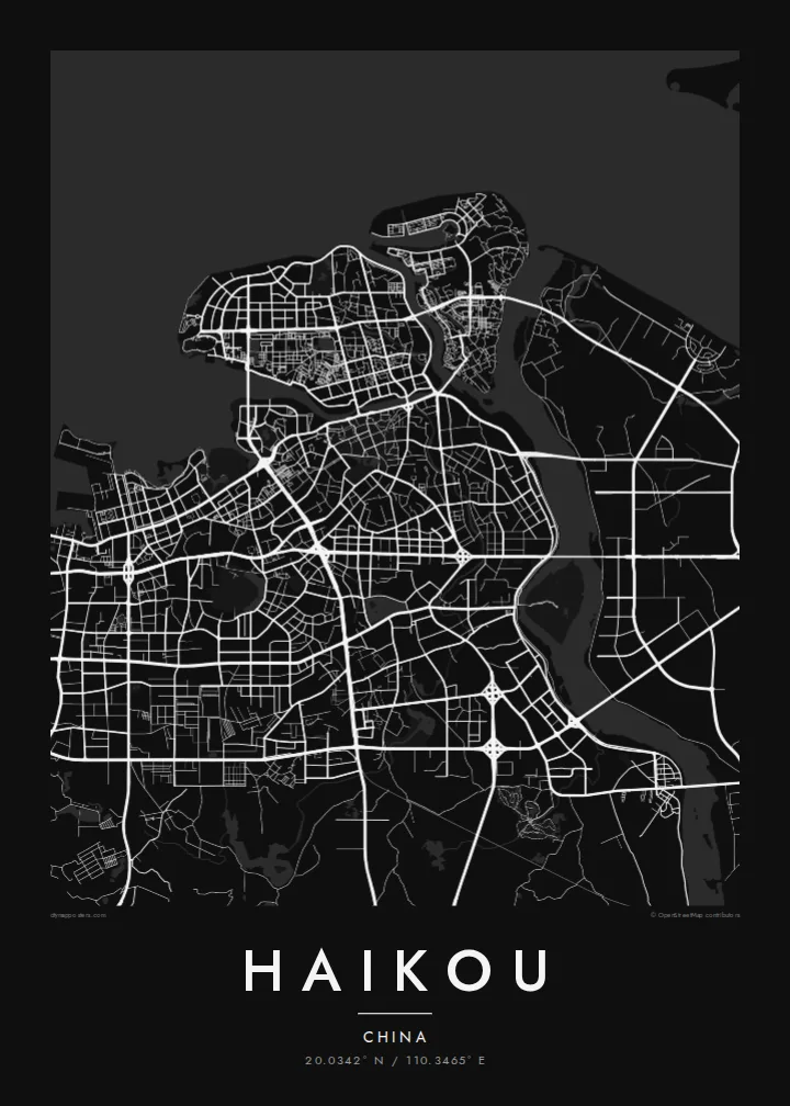
Haikou is the capital of Hainan and sits on the island's northern coast, facing mainland China across the Qiongzhou Strait. From above, the city spreads along a long, gently curved shoreline. The Nandu River, Hainan's largest river, reaches the sea here and breaks into channels and low islands, so the eastern side of the map is cut by water.
Haidian Island lies just off the old centre, separated by a narrow river channel and linked by several bridges. The older town near the waterfront keeps its denser, smaller streets, including the arcaded qilou buildings of the historic quarter. Further west and south, newer districts run on a wider, more regular grid of avenues, with parks and residential blocks in between.
The coast west of the centre is marked by beaches, a ferry port and long seafront roads. Inland to the southwest, the land rises slightly toward an old volcanic area. A Haikou map poster shows how the city is shaped by the strait on one side and the delta on the other, with the old port in the middle.
Hainan's longest river ends at Haikou and splits into several channels before reaching the sea. These branches and the islands between them define the eastern half of the city map.
A low island separated from the old centre by a narrow channel. Bridges cross to it at several points, and its northern edge follows the open coastline.
The historic centre near the river mouth has narrow streets lined with arcaded qilou buildings. On the map it appears as a compact, dense block of small streets next to the water.
Make it yours
Add a date, a name or a line of your own, switch style, size or orientation.
Free preview is low-resolution with a watermark. The HD version is 7,200 × 10,800 px, 300 DPI, no watermark.
Why Haikou
Haikou is where many journeys to Hainan begin, by ferry or plane, and it is home to people who know its seafront and river neighbourhoods well. Its outline of coast, delta and islands works well as a simple, clean wall piece.
You can personalise the title, subtitle and coordinates, for instance with a move date or a family name, and pick Classic black & white, Noir, Paper, Blueprint or Sand. Buy it as a digital file or have it printed and shipped.
Get the Haikou poster — $9| Print size | Resolution | Files |
|---|---|---|
| 30 × 40 cm | 3,543 × 4,724 px | PNG · PDF |
| 50 × 70 cm | 5,906 × 8,268 px | PNG · PDF |
| A3 · 29.7 × 42 cm | 3,508 × 4,961 px | PNG · PDF |
| A2 · 42 × 59.4 cm | 4,961 × 7,016 px | PNG · PDF |
| 18 × 24" | 5,400 × 7,200 px | PNG · PDF |
| 24 × 36" | 7,200 × 10,800 px | PNG · PDF |
For comparison, the free preview is 900 px wide, watermarked and meant for screens. The HD files have up to 8× the resolution in each direction and print cleanly at full poster size.
Yes. Drag and zoom the map in the editor — centre it on your neighbourhood, the old town or the whole metro area. The text updates independently.
The HD purchase includes 30×40 cm, 50×70 cm, A3, A2, 18×24″ and 24×36″, each as a 300 DPI PNG and a print-ready PDF.
You can download a free 900 px preview with a watermark. The paid HD files have no watermark and are sharp enough for large prints.
Send the PDF to any local print shop or online printing service and ask for the matching paper size. Matte paper and a thin black or oak frame suit this style best.
Nearby
