The Main riverbank
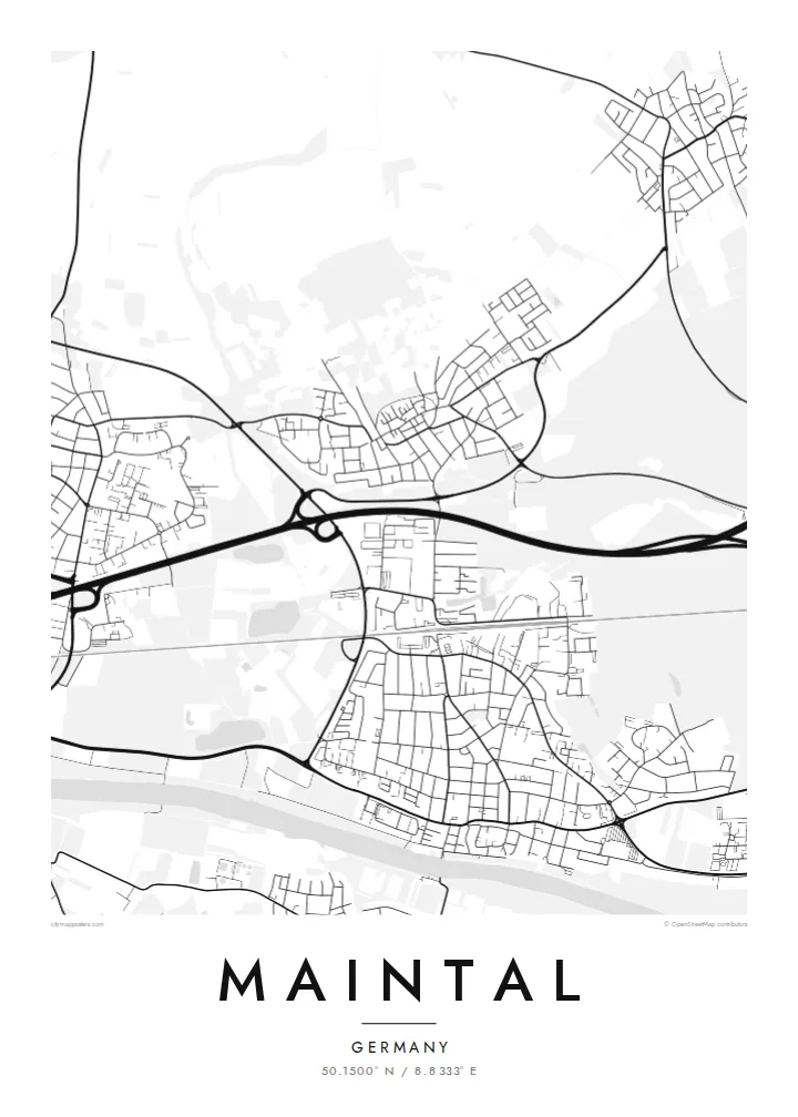
The river runs along the southern edge as a broad, calm band, giving the composition a firm base and showing how Dörnigheim's streets were drawn towards the water.
Minimalist map poster · Germany
50.1500° N / 8.8333° E
Four former villages stitched together on the north bank of the Main, between Frankfurt's eastern edge and Hanau
One city, five moods
Tap a style to see it on the wall. Every style costs the same — printed, framed or as HD files.
 Actual pixels · 24 × 36″ print file
Print-sharp
This is a 100% crop of the real print file. Every poster — printed, framed or downloaded — is rendered on our servers at 300 DPI, up to 7,200 × 10,800 pixels, so even the smallest lanes stay crisp on a 24 × 36″ print.
On the wall


The map
Maintal is a young town with old parts. It was formed in 1974, when Dörnigheim, Bischofsheim, Hochstadt and Wachenbuchen were merged into a single municipality in the Main-Kinzig district of Hesse. On a map the four cores are still easy to find, each with its own knot of older streets, joined by later housing, roads and rail.
The river Main forms the southern boundary, and Dörnigheim lies closest to it, with its streets running down towards the bank. Bischofsheim sits nearest to Frankfurt, while Hochstadt and Wachenbuchen are set further north, where the settlement pattern loosens into orchards and fields. The railway and the motorway cut east to west, tying the town into the Rhine-Main region.
Hochstadt is known for its preserved medieval wall and gate and for its apple-wine tradition, a reminder that this was a landscape of meadow orchards before it became commuter country. A Maintal map poster shows how those separate villages grew into one place without entirely losing their outlines, which is exactly what makes the drawing interesting.
The river runs along the southern edge as a broad, calm band, giving the composition a firm base and showing how Dörnigheim's streets were drawn towards the water.
Inside its surviving medieval wall, Hochstadt forms a small, tight cluster of lanes that stands out clearly against the more regular housing estates around it.
Look closely and the map shows four distinct points of density, each an original village, linked by roads and newer neighbourhoods that filled the gaps after the 1974 merger.
Make it yours
Add a date, a name or a line of your own, switch style, size or orientation.
The free preview is low-resolution with a watermark. Prints and HD files are rendered at 300 DPI, up to 7,200 × 10,800 px, without a watermark.
Why Maintal
Maintal suits people who know it from one particular part of town, whether they grew up in Bischofsheim or moved to Dörnigheim for the commute. The poster keeps all four districts on one sheet, which feels right for a town defined by joining.
Personalise the title, subtitle and coordinates line, perhaps naming your district or the year you moved in, and pick one of five styles: Classic black & white, Noir, Paper, Blueprint or Sand. Files cost $9, or order a print on matte paper with an optional wooden frame.
Order the Maintal poster| Print size | Resolution | Files |
|---|---|---|
| 30 × 40 cm11.8 × 15.7″ | 3,543 × 4,724 px | PNG · PDF |
| 29.7 × 42 cm (A3)11.7 × 16.5″ | 3,508 × 4,961 px | PNG · PDF |
| 42 × 59.4 cm (A2)16.5 × 23.4″ | 4,961 × 7,016 px | PNG · PDF |
| 45.7 × 61 cm18 × 24″ | 5,400 × 7,200 px | PNG · PDF |
| 50 × 70 cm19.7 × 27.6″ | 5,906 × 8,268 px | PNG · PDF |
| 61 × 91.4 cm24 × 36″ | 7,200 × 10,800 px | PNG · PDF |
For comparison, the free preview is 900 px wide, watermarked and meant for screens. The HD files have up to 8× the resolution in each direction and print cleanly at full poster size.
Pick a style at the top of the page, then choose Printed Poster — a size and, if you like, a frame — or Digital HD Files. Checkout takes one step, and your order page updates as soon as the payment goes through.
It is printed on premium 200 gsm matte paper in one of six sizes, from 30 × 40 cm to 24 × 36″. Printed posters start at $39, shipping included.
Yes. Choose a solid wood frame in black, white, natural oak or dark wood. It comes with shatterproof glazing and is ready to hang. Framed posters start at $99, shipping included.
Shipping is free to 60+ countries. Each poster is printed by the nearest of our print partners in 30+ countries and usually arrives in 3–7 business days. You can follow the status and tracking under My Orders. A few countries take 2–5 weeks, and where we don't ship yet, the site tells you before you pay.
Send us a photo within 14 days of delivery and we will reprint it for free or refund you.
Yes. In the editor on this page, change the title, the subtitle and the coordinates line to anything you like, and pick a style and size. Printed, framed and digital orders all use exactly your design.
For $9 you get 300 DPI PNG and print-ready PDF files in all six sizes, without a watermark, to print anywhere. Not sure yet? Download a free watermarked preview first.
Nearby
