Beltway interchange
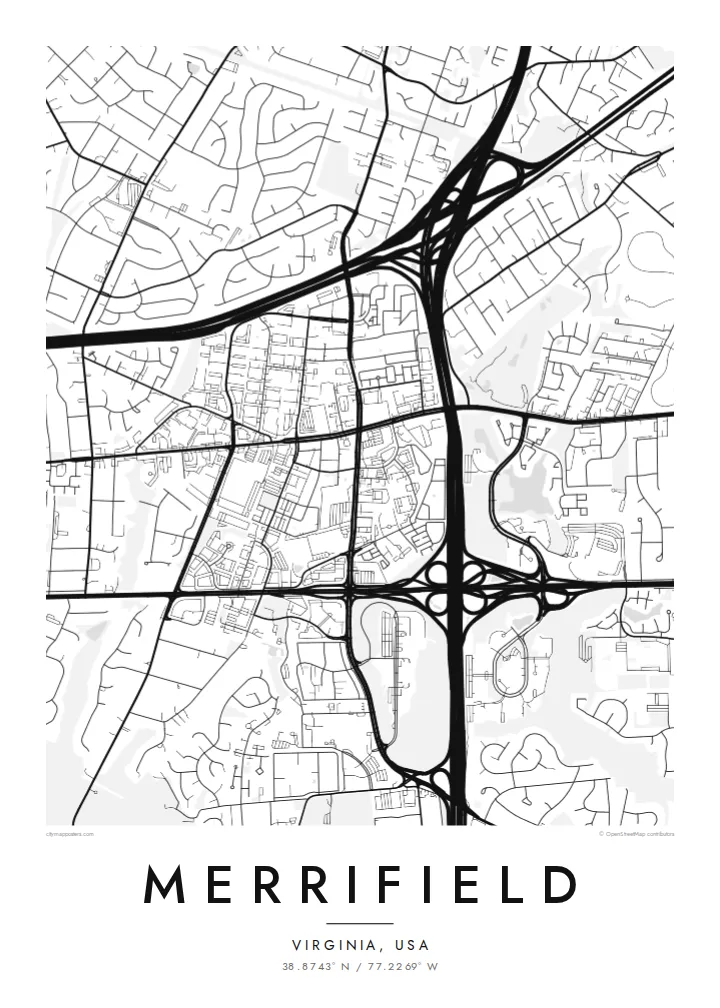
The meeting of I-495 and I-66 produces sweeping loops and ramps. On the poster they read almost like a drawn ornament among the ordinary streets.
Minimalist map poster · United States
38.8743° N / 77.2269° W
A Northern Virginia crossroads where the Beltway, I-66 and Metro tracks cut through suburban streets and new mixed-use blocks.
One city, five moods
Tap a style to see it on the wall. Every style costs the same — printed, framed or as HD files.
 Actual pixels · 24 × 36″ print file
Print-sharp
This is a 100% crop of the real print file. Every poster — printed, framed or downloaded — is rendered on our servers at 300 DPI, up to 7,200 × 10,800 pixels, so even the smallest lanes stay crisp on a 24 × 36″ print.
On the wall


The map
Merrifield is an unincorporated community in Fairfax County, Virginia, just inside the Capital Beltway, west of Washington. It is defined largely by infrastructure. The Beltway and Interstate 66 meet nearby, and their broad interchange ramps form some of the most striking curves on the map. Around them sit office parks, commercial strips and quiet residential streets that end in cul-de-sacs.
The Metro's Orange Line runs along the median of I-66, and the Dunn Loring–Merrifield station anchors a cluster of denser development. The best-known recent addition is the Mosaic District, a walkable mixed-use neighbourhood built on former commercial land. It shows up as a tighter grid of small blocks set against the larger footprints of the surrounding suburban roads.
A Merrifield map poster captures a very contemporary kind of American place. Highways, rail and planned neighbourhoods overlap, and wooded stream valleys still slip through between them. It is a good choice for people who live or work here, commute through the interchange every day, or bought a first home in this part of Fairfax County.
The meeting of I-495 and I-66 produces sweeping loops and ramps. On the poster they read almost like a drawn ornament among the ordinary streets.
Metro tracks run down the middle of I-66, and the Dunn Loring–Merrifield station forms a focal point with denser blocks growing around it.
A newer mixed-use neighbourhood of small, walkable blocks. It stands out on the map as a compact grid among the larger suburban parcels.
Make it yours
Add a date, a name or a line of your own, switch style, size or orientation.
The free preview is low-resolution with a watermark. Prints and HD files are rendered at 300 DPI, up to 7,200 × 10,800 px, without a watermark.
Why Merrifield
Merrifield is where many people start out in the Washington area, with a first apartment near the Metro or a first house off Gallows Road. A map poster turns that familiar tangle of highways and neighbourhoods into a clean record of a particular chapter of life.
Add your own title, a subtitle with a move-in date or an address, and a custom coordinates line. The five styles are Classic black and white, Noir, Paper, Blueprint and Sand. Blueprint suits the engineered interchanges well.
Order the Merrifield poster| Print size | Resolution | Files |
|---|---|---|
| 30 × 40 cm11.8 × 15.7″ | 3,543 × 4,724 px | PNG · PDF |
| 29.7 × 42 cm (A3)11.7 × 16.5″ | 3,508 × 4,961 px | PNG · PDF |
| 42 × 59.4 cm (A2)16.5 × 23.4″ | 4,961 × 7,016 px | PNG · PDF |
| 45.7 × 61 cm18 × 24″ | 5,400 × 7,200 px | PNG · PDF |
| 50 × 70 cm19.7 × 27.6″ | 5,906 × 8,268 px | PNG · PDF |
| 61 × 91.4 cm24 × 36″ | 7,200 × 10,800 px | PNG · PDF |
For comparison, the free preview is 900 px wide, watermarked and meant for screens. The HD files have up to 8× the resolution in each direction and print cleanly at full poster size.
Pick a style at the top of the page, then choose Printed Poster — a size and, if you like, a frame — or Digital HD Files. Checkout takes one step, and your order page updates as soon as the payment goes through.
It is printed on premium 200 gsm matte paper in one of six sizes, from 30 × 40 cm to 24 × 36″. Printed posters start at $39, shipping included.
Yes. Choose a solid wood frame in black, white, natural oak or dark wood. It comes with shatterproof glazing and is ready to hang. Framed posters start at $99, shipping included.
Shipping is free to 60+ countries. Each poster is printed by the nearest of our print partners in 30+ countries and usually arrives in 3–7 business days. You can follow the status and tracking under My Orders. A few countries take 2–5 weeks, and where we don't ship yet, the site tells you before you pay.
Send us a photo within 14 days of delivery and we will reprint it for free or refund you.
Yes. In the editor on this page, change the title, the subtitle and the coordinates line to anything you like, and pick a style and size. Printed, framed and digital orders all use exactly your design.
For $9 you get 300 DPI PNG and print-ready PDF files in all six sizes, without a watermark, to print anywhere. Not sure yet? Download a free watermarked preview first.
Nearby
