The historic core
A small cluster of older streets around the parish church and the central square, visibly finer-grained than the planned residential blocks that spread out from it in every direction.
Minimalist map poster · Spain
40.3223° N / 3.8650° W
A compact satellite city southwest of Madrid, its dense blocks ringed by motorways, rail lines and open Castilian farmland.

One city, five moods
Tap a style to see it on the wall. Every style costs the same — printed, framed or as HD files.
 Actual pixels · 24 × 36″ print file
Print-sharp
This is a 100% crop of the real print file. Every poster — printed, framed or downloaded — is rendered on our servers at 300 DPI, up to 7,200 × 10,800 pixels, so even the smallest lanes stay crisp on a 24 × 36″ print.
On the wall


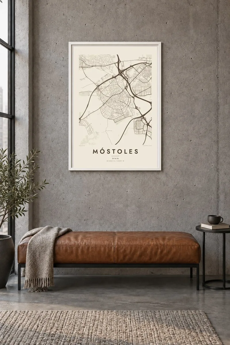
The map
Móstoles sits just under twenty kilometres southwest of central Madrid, and from above it reads as a single tight mass of apartment blocks with a clear edge. Until the 1960s it was a farming village. Within two decades it had become one of the largest cities in the region, and the map still shows that speed, with regular estates laid out quickly around a small historic core.
The old centre is easy to find: a knot of short, irregular streets around the parish church and the town square, surrounded by the long straight avenues of the newer districts. Along the northern edge, the A-5 motorway toward Extremadura draws a firm line, the M-50 orbital passes close by, and rail lines tie the city to its neighbours Alcorcón and Fuenlabrada.
Móstoles holds a small but lasting place in Spanish history. On 2 May 1808 its mayors issued a proclamation calling the country to rise against Napoleon's troops, a moment the town still commemorates. A Móstoles map poster captures the city as it is today, with its university campus, broad parks and clean suburban boundary rendered in fine black lines on white.
A small cluster of older streets around the parish church and the central square, visibly finer-grained than the planned residential blocks that spread out from it in every direction.
The A-5 and the nearby M-50 orbital frame the city with long, confident curves, giving the poster a strong outer edge against the fields and scrubland beyond.
The Móstoles campus of Universidad Rey Juan Carlos appears as a distinct open block of buildings, lawns and paths, a quieter pattern set against the surrounding housing estates.
Make it yours
Add a date, a name or a line of your own, switch style, size or orientation.
The free preview is low-resolution with a watermark. Prints and HD files are rendered at 300 DPI, up to 7,200 × 10,800 px, without a watermark.
Why Móstoles
For people who grew up in Móstoles or commute from it, the map shows a familiar place in a way it is rarely seen: whole, with its edges and old centre in one frame. It suits a hallway, a first flat or a gift for someone who moved away.
You can personalise the title, subtitle and coordinates line, adding a neighbourhood name or a date that matters, and choose from five styles: Classic black & white, Noir, Paper, Blueprint or Sand. The HD files cost $9 and include six print sizes as 300 DPI PNG and print-ready PDF.
Order the Móstoles poster| Print size | Resolution | Files |
|---|---|---|
| 30 × 40 cm11.8 × 15.7″ | 3,543 × 4,724 px | PNG · PDF |
| 29.7 × 42 cm (A3)11.7 × 16.5″ | 3,508 × 4,961 px | PNG · PDF |
| 42 × 59.4 cm (A2)16.5 × 23.4″ | 4,961 × 7,016 px | PNG · PDF |
| 45.7 × 61 cm18 × 24″ | 5,400 × 7,200 px | PNG · PDF |
| 50 × 70 cm19.7 × 27.6″ | 5,906 × 8,268 px | PNG · PDF |
| 61 × 91.4 cm24 × 36″ | 7,200 × 10,800 px | PNG · PDF |
For comparison, the free preview is 900 px wide, watermarked and meant for screens. The HD files have up to 8× the resolution in each direction and print cleanly at full poster size.
Pick a style at the top of the page, then choose Printed Poster — a size and, if you like, a frame — or Digital HD Files. Checkout takes one step, and your order page updates as soon as the payment goes through.
It is printed on premium 200 gsm matte paper in one of six sizes, from 30 × 40 cm to 24 × 36″. Printed posters start at $39, shipping included.
Yes. Choose a solid wood frame in black, white, natural oak or dark wood. It comes with shatterproof glazing and is ready to hang. Framed posters start at $99, shipping included.
Shipping is free to 60+ countries. Each poster is printed by the nearest of our print partners in 30+ countries and usually arrives in 3–7 business days. You can follow the status and tracking under My Orders. A few countries take 2–5 weeks, and where we don't ship yet, the site tells you before you pay.
Send us a photo within 14 days of delivery and we will reprint it for free or refund you.
Yes. In the editor on this page, change the title, the subtitle and the coordinates line to anything you like, and pick a style and size. Printed, framed and digital orders all use exactly your design.
For $9 you get 300 DPI PNG and print-ready PDF files in all six sizes, without a watermark, to print anywhere. Not sure yet? Download a free watermarked preview first.
Nearby
