Hilltop historic centre
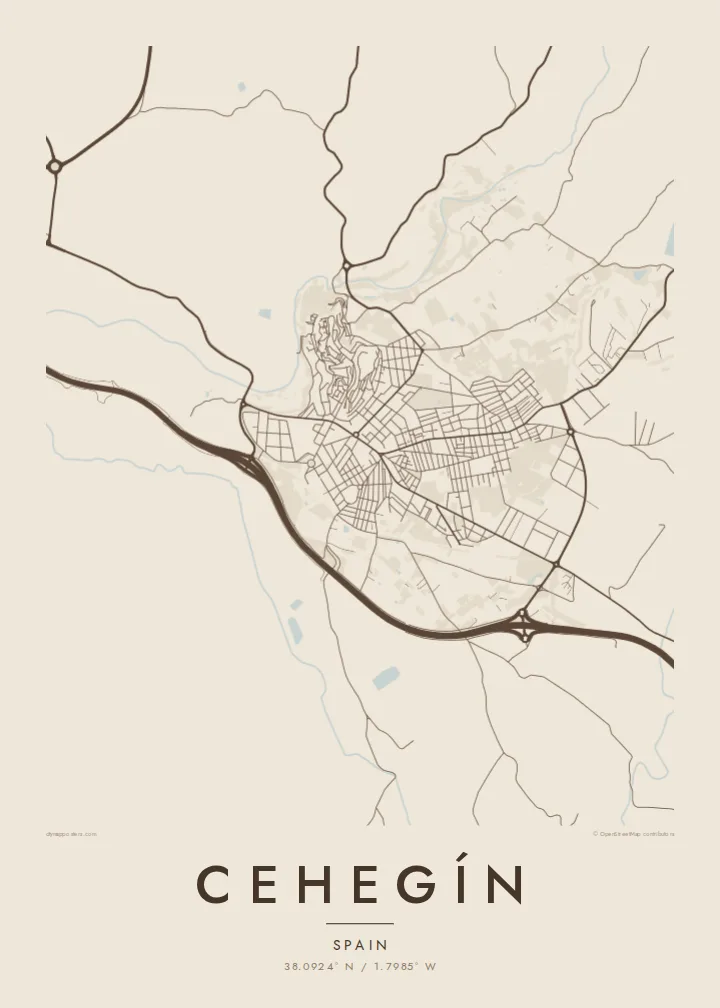
The protected old town covers the summit in a mesh of short, crooked lanes. It is the most intricate part of the map and immediately draws the eye.
Poster minimalist tal-mappa · Spanja
38.0924° N / 1.7985° W
A hilltop old town in northwest Murcia, its tight medieval lanes perched above the valley of the river Argos.


Belt waħda, ħames atmosferi
Agħfas fuq stil biex tarah fuq il-ħajt. Kull stil jiswa l-istess — stampat, inkurnat jew bħala fajls HD.
 Pixels reali · fajl tal-istampar 24 × 36″
Preċiż għall-istampar
Dan huwa qtugħ ta' 100% mill-fajl tal-istampar reali. Kull poster — stampat, inkurnat jew iddawnlowdjat — jiġi ġġenerat fuq is-servers tagħna b'300 DPI, sa 7,200 × 10,800 pixel, biex saħansitra l-iżgħar toroq jibqgħu ċari fuq stampa ta' 24 × 36″.
Fuq il-ħajt


Il-mappa
Cehegín stands in the northwest of the Region of Murcia, on a hill above the valley of the river Argos. The historic centre, protected as a conjunto histórico, occupies the top of that hill. From above, it forms a knot of steep, irregular lanes that stands out sharply from the grid of newer streets below.
The old quarter keeps churches and noble houses built between the sixteenth and eighteenth centuries, and its narrow streets follow the slope rather than any plan. Nearby lies the site of Begastri, a Roman and Visigothic town. The neighbouring town of Caravaca de la Cruz is a short distance to the west.
A Cehegín map poster reads almost like a relief drawing. The dense old town sits at the top, streets unwind down its sides, and the lower districts spread across flatter ground toward orchards and the river. The contrast between the two halves gives the print a strong natural focal point.
The protected old town covers the summit in a mesh of short, crooked lanes. It is the most intricate part of the map and immediately draws the eye.
Below the town, the river Argos and its irrigated land form a green corridor. On the map it shows as a softer, flowing band beneath the hill.
Newer neighbourhoods fill the flatter ground below the old centre with regular blocks and wider roads. Their order contrasts clearly with the medieval streets above.
Agħmlu tiegħek
Żid data, isem jew sentenza tiegħek, ibdel l-istil, id-daqs jew l-orjentazzjoni.
Il-preview b'xejn hija b'riżoluzzjoni baxxa u bil-watermark. L-istampi u l-fajls HD jiġu ġġenerati b'300 DPI, sa 7,200 × 10,800 px, mingħajr watermark.
Għaliex Cehegín
Cehegín is a town people carry with them: the climb through the old quarter, the view over the valley, the fiestas each year. A map of it is a way to keep that geography in the home, especially for those who have moved away to Murcia, Madrid or abroad.
The title, subtitle and coordinates line are all editable, so the poster can mark a wedding, a birth or a family house. Pick from Classic black & white, Noir, Paper, Blueprint and Sand. HD files cost $9 and have no watermark.
Ordna l-poster Cehegín| Daqs tal-istampa | Riżoluzzjoni | Fajls |
|---|---|---|
| 30 × 40 cm (11.8 × 15.7″) | 3,543 × 4,724 px | PNG · PDF |
| 29.7 × 42 cm (A3, 11.7 × 16.5″) | 3,508 × 4,961 px | PNG · PDF |
| 42 × 59.4 cm (A2, 16.5 × 23.4″) | 4,961 × 7,016 px | PNG · PDF |
| 45.7 × 61 cm (18 × 24″) | 5,400 × 7,200 px | PNG · PDF |
| 50 × 70 cm (19.7 × 27.6″) | 5,906 × 8,268 px | PNG · PDF |
| 61 × 91.4 cm (24 × 36″) | 7,200 × 10,800 px | PNG · PDF |
Għal paragun, il-preview b'xejn huwa wiesa' 900 px, għandu watermark u huwa maħsub għall-iskrins. Il-fajls HD għandhom sa 8× ir-riżoluzzjoni f'kull direzzjoni u jiġu stampati b'mod nadif fid-daqs sħiħ tal-poster.
Agħżel stil fin-naħa ta' fuq tal-paġna, imbagħad agħżel Poster Stampat — daqs u, jekk trid, kurniċa — jew Fajls Diġitali HD. Il-ħlas isir f'pass wieħed, u l-paġna tal-ordni tiegħek tiġi aġġornata malli l-ħlas jgħaddi.
Jiġi stampat fuq karta matte premium ta' 200 gsm f'wieħed minn sitt daqsijiet, minn 30 × 40 cm sa 24 × 36″. Il-posters stampati jibdew minn {printFrom}, bil-kunsinna inkluża.
Iva. Agħżel kurniċa tal-injam solidu f'iswed, abjad, ballut naturali jew injam skur. Tiġi bi ħġieġ li ma jinkisirx u lesta biex tittella'. Il-posters inkurnati jibdew minn {framedFrom}, bil-kunsinna inkluża.
Il-kunsinna hija b'xejn madwar id-dinja. Kull poster jiġi stampat mill-eqreb sieħeb tal-istampar tagħna f'aktar minn 30 pajjiż u ġeneralment jasal fi 3–7 ijiem tax-xogħol. Tista' ssegwi l-istatus u t-tracking taħt L-Ordnijiet Tiegħi.
Ibgħatilna ritratt fi żmien 14-il jum mill-kunsinna u aħna nistampawh mill-ġdid b'xejn jew nirrimborżawk.
Iva. Fl-editur ta' din il-paġna, biddel it-titlu, is-sottotitlu u l-linja tal-koordinati għal kwalunkwe ħaġa trid, u agħżel stil u daqs. L-ordnijiet stampati, inkurnati u diġitali kollha jużaw eżattament id-disinn tiegħek.
Għal $9 tikseb fajls PNG b'300 DPI u PDF lesti għall-istampar fis-sitt daqsijiet kollha, mingħajr watermark, biex tistampa kullimkien. Għadek mhux ċert? L-ewwel iddawnlowdja preview b'xejn bil-watermark.
