Mississippi bend
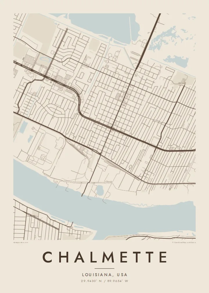
The river sweeps along the town's northern edge in a wide arc, its banks lined with the levee, wharves and industrial sites that face the shipping channel.
Poster minimalist tal-mappa · l-Istati Uniti
29.9430° N / 89.9654° W
A riverside grid on the Mississippi's east bank, levee on one side and wetlands opening toward the Gulf on the other


Belt waħda, ħames atmosferi
Agħfas fuq stil biex tarah fuq il-ħajt. Kull stil jiswa l-istess — stampat, inkurnat jew bħala fajls HD.
 Pixels reali · fajl tal-istampar 24 × 36″
Preċiż għall-istampar
Dan huwa qtugħ ta' 100% mill-fajl tal-istampar reali. Kull poster — stampat, inkurnat jew iddawnlowdjat — jiġi ġġenerat fuq is-servers tagħna b'300 DPI, sa 7,200 × 10,800 pixel, biex saħansitra l-iżgħar toroq jibqgħu ċari fuq stampa ta' 24 × 36″.
Fuq il-ħajt


Il-mappa
Chalmette lies just downriver from New Orleans in St. Bernard Parish, on a strip of higher ground along the east bank of the Mississippi. On a map the river curves across the top of the town, lined by the levee and industrial frontage. Behind it, a regular grid of residential streets fills the land between the river and the marshes that stretch away toward the east.
The town is best known as the site of the Battle of New Orleans in January 1815. The battlefield, now part of Jean Lafitte National Historical Park and Preserve, sits beside the river as an open rectangle of land, clearly visible among the surrounding blocks. The same low ground made Chalmette one of the places hit hardest by the flooding after Hurricane Katrina in 2005.
A Chalmette map poster shows how closely life here depends on water. The broad bend of the river, the straight canals and drainage lines, and the grid that stops at the wetland edge together describe a place defined by elevation measured in feet. In monochrome that relationship is easy to read at a glance.
The river sweeps along the town's northern edge in a wide arc, its banks lined with the levee, wharves and industrial sites that face the shipping channel.
The 1815 battlefield is an open, rectangular green by the river. On the poster it appears as a calm gap among the streets, with the national cemetery next to it.
Residential blocks run in an orderly grid until they meet canals and wetlands. That boundary between built land and open water gives the map its character.
Agħmlu tiegħek
Żid data, isem jew sentenza tiegħek, ibdel l-istil, id-daqs jew l-orjentazzjoni.
Il-preview b'xejn hija b'riżoluzzjoni baxxa u bil-watermark. L-istampi u l-fajls HD jiġu ġġenerati b'300 DPI, sa 7,200 × 10,800 px, mingħajr watermark.
Għaliex Chalmette
For people from St. Bernard Parish, Chalmette often stands for family history, rebuilding after the storm and a strong sense of home. A map of the streets people returned to can mean more than any photograph, especially for families now spread across the South.
Personalise the title, subtitle and coordinates line with a family name, a street or a meaningful year. Then choose one of five styles: Classic black & white, Noir, Paper, Blueprint or Sand. Noir makes the river and the wetlands particularly striking.
Ordna l-poster Chalmette| Daqs tal-istampa | Riżoluzzjoni | Fajls |
|---|---|---|
| 30 × 40 cm11.8 × 15.7″ | 3,543 × 4,724 px | PNG · PDF |
| 29.7 × 42 cm (A3)11.7 × 16.5″ | 3,508 × 4,961 px | PNG · PDF |
| 42 × 59.4 cm (A2)16.5 × 23.4″ | 4,961 × 7,016 px | PNG · PDF |
| 45.7 × 61 cm18 × 24″ | 5,400 × 7,200 px | PNG · PDF |
| 50 × 70 cm19.7 × 27.6″ | 5,906 × 8,268 px | PNG · PDF |
| 61 × 91.4 cm24 × 36″ | 7,200 × 10,800 px | PNG · PDF |
Għal paragun, il-preview b'xejn huwa wiesa' 900 px, għandu watermark u huwa maħsub għall-iskrins. Il-fajls HD għandhom sa 8× ir-riżoluzzjoni f'kull direzzjoni u jiġu stampati b'mod nadif fid-daqs sħiħ tal-poster.
Agħżel stil fin-naħa ta' fuq tal-paġna, imbagħad agħżel Poster Stampat — daqs u, jekk trid, kurniċa — jew Fajls Diġitali HD. Il-ħlas isir f'pass wieħed, u l-paġna tal-ordni tiegħek tiġi aġġornata malli l-ħlas jgħaddi.
Jiġi stampat fuq karta matte premium ta' 200 gsm f'wieħed minn sitt daqsijiet, minn 30 × 40 cm sa 24 × 36″. Il-posters stampati jibdew minn $39, bil-kunsinna inkluża.
Iva. Agħżel kurniċa tal-injam solidu f'iswed, abjad, ballut naturali jew injam skur. Tiġi bi ħġieġ li ma jinkisirx u lesta biex tittella'. Il-posters inkurnati jibdew minn $99, bil-kunsinna inkluża.
It-tbaħħir huwa b'xejn lejn 60+ pajjiż. Kull poster jiġi stampat mill-eqreb wieħed mis-sieħba tal-istampar tagħna f'30+ pajjiż u normalment jaslek fi 3–7 ijiem tax-xogħol. Tista' ssegwi l-istatus u t-traċċar taħt L-Ordnijiet Tiegħi. Xi pajjiżi jieħdu 2–5 ġimgħat, u fejn għadna ma nibagħtux, is-sit jgħidlek qabel tħallas.
Ibgħatilna ritratt fi żmien 14-il jum mill-kunsinna u aħna nistampawh mill-ġdid b'xejn jew nirrimborżawk.
Iva. Fl-editur ta' din il-paġna, biddel it-titlu, is-sottotitlu u l-linja tal-koordinati għal kwalunkwe ħaġa trid, u agħżel stil u daqs. L-ordnijiet stampati, inkurnati u diġitali kollha jużaw eżattament id-disinn tiegħek.
Għal $9 tikseb fajls PNG b'300 DPI u PDF lesti għall-istampar fis-sitt daqsijiet kollha, mingħajr watermark, biex tistampa kullimkien. Għadek mhux ċert? L-ewwel iddawnlowdja preview b'xejn bil-watermark.
