Davao Gulf shore
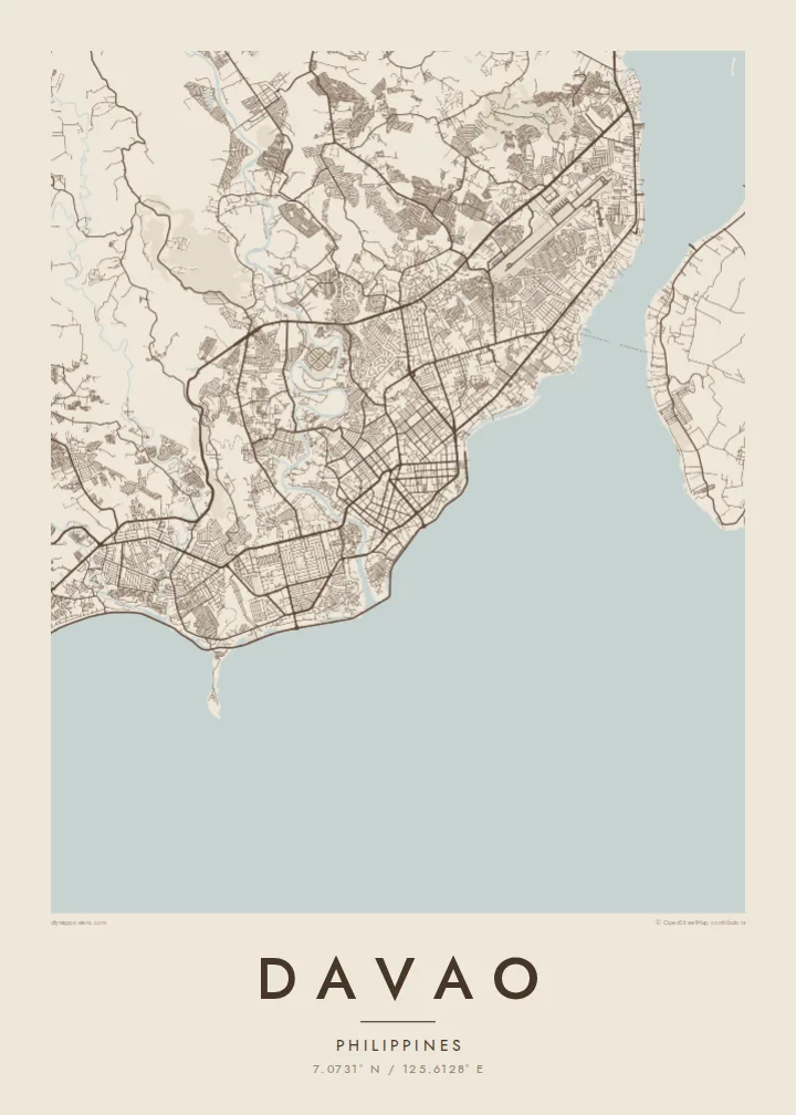
The coastline curves along the eastern edge of the city, where the port, downtown streets and seaside roads crowd together along the water.
Poster minimalist tal-mappa · il-Filippini
7.0731° N / 125.6128° E
A gulf-side city on Mindanao that runs from a crowded shoreline up into river valleys and forested slopes toward Mount Apo.


Belt waħda, ħames atmosferi
Agħfas fuq stil biex tarah fuq il-ħajt. Kull stil jiswa l-istess — stampat, inkurnat jew bħala fajls HD.
 Pixels reali · fajl tal-istampar 24 × 36″
Preċiż għall-istampar
Dan huwa qtugħ ta' 100% mill-fajl tal-istampar reali. Kull poster — stampat, inkurnat jew iddawnlowdjat — jiġi ġġenerat fuq is-servers tagħna b'300 DPI, sa 7,200 × 10,800 pixel, biex saħansitra l-iżgħar toroq jibqgħu ċari fuq stampa ta' 24 × 36″.
Fuq il-ħajt


Il-mappa
Davao is the largest city on Mindanao, in the southern Philippines, and one of the largest cities in the country by land area. Its urban core faces Davao Gulf, while the city limits stretch far inland across farmland, river valleys and forested uplands toward Mount Apo, the highest mountain in the Philippines. The map has two moods: dense along the coast, open and rugged behind it.
The Davao River reaches the gulf near the centre, and the downtown streets, port areas and main avenues gather around its mouth and along the shore. Across the narrow Pakiputan Strait lies Samal Island, close enough to appear on the poster as a large landmass just offshore, framing the city's waterfront from the east.
Davao is known for durian and for the Philippine eagle, which is bred and protected at a conservation centre on the city's outskirts. A Davao map poster shows how the city holds its place between sea and mountain: the dense streets by the water, the rivers coming down from the interior and the island lying across the strait.
The coastline curves along the eastern edge of the city, where the port, downtown streets and seaside roads crowd together along the water.
The large island across the strait appears as a separate, rounded form offshore, giving the composition a strong second shape beside the city.
The river winds down from the interior and reaches the gulf near the centre, a thin, curving line drawn through the dense urban blocks.
Agħmlu tiegħek
Żid data, isem jew sentenza tiegħek, ibdel l-istil, id-daqs jew l-orjentazzjoni.
Il-preview b'xejn hija b'riżoluzzjoni baxxa u bil-watermark. L-istampi u l-fajls HD jiġu ġġenerati b'300 DPI, sa 7,200 × 10,800 px, mingħajr watermark.
Għaliex Davao
Davao holds meaning for people who grew up there and for the many who moved to it for work or study. A map of its coast, river and island is a calm reminder of a place defined by sea and mountain.
You can personalise the title, subtitle and coordinates, then choose between Classic black & white, Noir, Paper, Blueprint and Sand. HD files in six sizes cost $9, or the poster can be printed and delivered through partners in more than 30 countries.
Ordna l-poster Davao| Daqs tal-istampa | Riżoluzzjoni | Fajls |
|---|---|---|
| 30 × 40 cm (11.8 × 15.7″) | 3,543 × 4,724 px | PNG · PDF |
| 29.7 × 42 cm (A3, 11.7 × 16.5″) | 3,508 × 4,961 px | PNG · PDF |
| 42 × 59.4 cm (A2, 16.5 × 23.4″) | 4,961 × 7,016 px | PNG · PDF |
| 45.7 × 61 cm (18 × 24″) | 5,400 × 7,200 px | PNG · PDF |
| 50 × 70 cm (19.7 × 27.6″) | 5,906 × 8,268 px | PNG · PDF |
| 61 × 91.4 cm (24 × 36″) | 7,200 × 10,800 px | PNG · PDF |
Għal paragun, il-preview b'xejn huwa wiesa' 900 px, għandu watermark u huwa maħsub għall-iskrins. Il-fajls HD għandhom sa 8× ir-riżoluzzjoni f'kull direzzjoni u jiġu stampati b'mod nadif fid-daqs sħiħ tal-poster.
Agħżel stil fin-naħa ta' fuq tal-paġna, imbagħad agħżel Poster Stampat — daqs u, jekk trid, kurniċa — jew Fajls Diġitali HD. Il-ħlas isir f'pass wieħed, u l-paġna tal-ordni tiegħek tiġi aġġornata malli l-ħlas jgħaddi.
Jiġi stampat fuq karta matte premium ta' 200 gsm f'wieħed minn sitt daqsijiet, minn 30 × 40 cm sa 24 × 36″. Il-posters stampati jibdew minn {printFrom}, bil-kunsinna inkluża.
Iva. Agħżel kurniċa tal-injam solidu f'iswed, abjad, ballut naturali jew injam skur. Tiġi bi ħġieġ li ma jinkisirx u lesta biex tittella'. Il-posters inkurnati jibdew minn {framedFrom}, bil-kunsinna inkluża.
Il-kunsinna hija b'xejn madwar id-dinja. Kull poster jiġi stampat mill-eqreb sieħeb tal-istampar tagħna f'aktar minn 30 pajjiż u ġeneralment jasal fi 3–7 ijiem tax-xogħol. Tista' ssegwi l-istatus u t-tracking taħt L-Ordnijiet Tiegħi.
Ibgħatilna ritratt fi żmien 14-il jum mill-kunsinna u aħna nistampawh mill-ġdid b'xejn jew nirrimborżawk.
Iva. Fl-editur ta' din il-paġna, biddel it-titlu, is-sottotitlu u l-linja tal-koordinati għal kwalunkwe ħaġa trid, u agħżel stil u daqs. L-ordnijiet stampati, inkurnati u diġitali kollha jużaw eżattament id-disinn tiegħek.
Għal $9 tikseb fajls PNG b'300 DPI u PDF lesti għall-istampar fis-sitt daqsijiet kollha, mingħajr watermark, biex tistampa kullimkien. Għadek mhux ċert? L-ewwel iddawnlowdja preview b'xejn bil-watermark.
