Leidse Rijn
The old waterway runs through the village, and the historic streets follow it. On the print it appears as a thin, steady line with buildings along both sides.
Poster minimalist tal-mappa · in-Netherlands
52.0817° N / 5.0361° E
A former village on the old Rhine course west of Utrecht, now framed by motorways, canals and the new Leidsche Rijn district



Belt waħda, ħames atmosferi
Agħfas fuq stil biex tarah fuq il-ħajt. Kull stil jiswa l-istess — stampat, inkurnat jew bħala fajls HD.
 Pixels reali · fajl tal-istampar 24 × 36″
Preċiż għall-istampar
Dan huwa qtugħ ta' 100% mill-fajl tal-istampar reali. Kull poster — stampat, inkurnat jew iddawnlowdjat — jiġi ġġenerat fuq is-servers tagħna b'300 DPI, sa 7,200 × 10,800 pixel, biex saħansitra l-iżgħar toroq jibqgħu ċari fuq stampa ta' 24 × 36″.
Fuq il-ħajt


Il-mappa
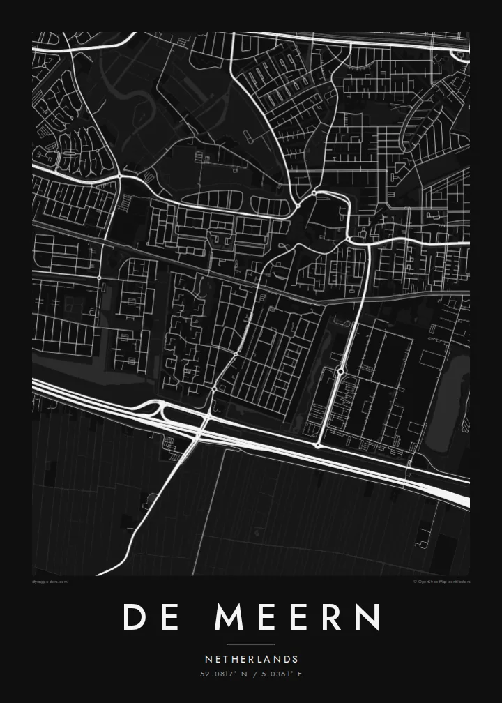
De Meern lies just west of Utrecht, part of the combined district of Vleuten-De Meern. From above, the older village follows the line of the Leidse Rijn, a waterway along an old course of the Rhine. Long, narrow streets run parallel to the water, and a straight, flat pattern of Dutch polder fields surrounds it.
That old river route was once the northern frontier of the Roman Empire. In 2003, archaeologists found a well-preserved Roman river barge here, known as De Meern 1. The nearby Roman fort site at Hoge Woerd is now marked by a reconstructed castellum. Around the village, the new Leidsche Rijn development has added large planned neighbourhoods, parks and water features.
A De Meern map poster combines different eras: a linear village along the water, modern curving neighbourhoods, straight drainage ditches and the motorways that pass nearby. It suits people who moved into the new district, those who grew up in the old village and anyone with an interest in the Roman frontier.
The old waterway runs through the village, and the historic streets follow it. On the print it appears as a thin, steady line with buildings along both sides.
The Limes once ran along this river course. The site at Hoge Woerd, where a Roman fort stood, is part of the area shown on the map.
The planned neighbourhoods of Leidsche Rijn surround the older village with parks, canals and curving streets. Together they make a sharp contrast with the linear core.
Agħmlu tiegħek
Żid data, isem jew sentenza tiegħek, ibdel l-istil, id-daqs jew l-orjentazzjoni.
Il-preview b'xejn hija b'riżoluzzjoni baxxa u bil-watermark. L-istampi u l-fajls HD jiġu ġġenerati b'300 DPI, sa 7,200 × 10,800 px, mingħajr watermark.
Għaliex De Meern
Many families moved to De Meern as the new district grew, and a map marks that first home well. Longtime residents often choose it to show how the old village sits within the new city.
Put your street, family name or moving-in date in the title and subtitle, and keep the coordinates. Choose Classic black & white, Noir, Paper, Blueprint or Sand. Blueprint shows the waterways clearly.
Ordna l-poster De Meern| Daqs tal-istampa | Riżoluzzjoni | Fajls |
|---|---|---|
| 30 × 40 cm11.8 × 15.7″ | 3,543 × 4,724 px | PNG · PDF |
| 29.7 × 42 cm (A3)11.7 × 16.5″ | 3,508 × 4,961 px | PNG · PDF |
| 42 × 59.4 cm (A2)16.5 × 23.4″ | 4,961 × 7,016 px | PNG · PDF |
| 45.7 × 61 cm18 × 24″ | 5,400 × 7,200 px | PNG · PDF |
| 50 × 70 cm19.7 × 27.6″ | 5,906 × 8,268 px | PNG · PDF |
| 61 × 91.4 cm24 × 36″ | 7,200 × 10,800 px | PNG · PDF |
Għal paragun, il-preview b'xejn huwa wiesa' 900 px, għandu watermark u huwa maħsub għall-iskrins. Il-fajls HD għandhom sa 8× ir-riżoluzzjoni f'kull direzzjoni u jiġu stampati b'mod nadif fid-daqs sħiħ tal-poster.
Agħżel stil fin-naħa ta' fuq tal-paġna, imbagħad agħżel Poster Stampat — daqs u, jekk trid, kurniċa — jew Fajls Diġitali HD. Il-ħlas isir f'pass wieħed, u l-paġna tal-ordni tiegħek tiġi aġġornata malli l-ħlas jgħaddi.
Jiġi stampat fuq karta matte premium ta' 200 gsm f'wieħed minn sitt daqsijiet, minn 30 × 40 cm sa 24 × 36″. Il-posters stampati jibdew minn $39, bil-kunsinna inkluża.
Iva. Agħżel kurniċa tal-injam solidu f'iswed, abjad, ballut naturali jew injam skur. Tiġi bi ħġieġ li ma jinkisirx u lesta biex tittella'. Il-posters inkurnati jibdew minn $99, bil-kunsinna inkluża.
It-tbaħħir huwa b'xejn lejn 60+ pajjiż. Kull poster jiġi stampat mill-eqreb wieħed mis-sieħba tal-istampar tagħna f'30+ pajjiż u normalment jaslek fi 3–7 ijiem tax-xogħol. Tista' ssegwi l-istatus u t-traċċar taħt L-Ordnijiet Tiegħi. Xi pajjiżi jieħdu 2–5 ġimgħat, u fejn għadna ma nibagħtux, is-sit jgħidlek qabel tħallas.
Ibgħatilna ritratt fi żmien 14-il jum mill-kunsinna u aħna nistampawh mill-ġdid b'xejn jew nirrimborżawk.
Iva. Fl-editur ta' din il-paġna, biddel it-titlu, is-sottotitlu u l-linja tal-koordinati għal kwalunkwe ħaġa trid, u agħżel stil u daqs. L-ordnijiet stampati, inkurnati u diġitali kollha jużaw eżattament id-disinn tiegħek.
Għal $9 tikseb fajls PNG b'300 DPI u PDF lesti għall-istampar fis-sitt daqsijiet kollha, mingħajr watermark, biex tistampa kullimkien. Għadek mhux ċert? L-ewwel iddawnlowdja preview b'xejn bil-watermark.
