Road junction
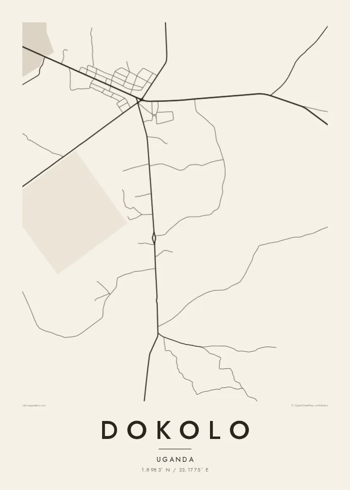
The town grew where regional roads meet. On the map the junction is its clear centre, with streets and plots arranged around it.
Poster minimalist tal-mappa · l-Uganda
1.8983° N / 33.1775° E
A small Lango town on a crossroads of red-earth roads, with farmland and lake wetlands spreading out on every side




Belt waħda, ħames atmosferi
Agħfas fuq stil biex tarah fuq il-ħajt. Kull stil jiswa l-istess — stampat, inkurnat jew bħala fajls HD.
 Pixels reali · fajl tal-istampar 24 × 36″
Preċiż għall-istampar
Dan huwa qtugħ ta' 100% mill-fajl tal-istampar reali. Kull poster — stampat, inkurnat jew iddawnlowdjat — jiġi ġġenerat fuq is-servers tagħna b'300 DPI, sa 7,200 × 10,800 pixel, biex saħansitra l-iżgħar toroq jibqgħu ċari fuq stampa ta' 24 × 36″.
Fuq il-ħajt


Il-mappa
Dokolo is the administrative town of Dokolo District in northern Uganda's Lango sub-region. On a map it looks compact: a short run of streets gathered around the point where regional roads meet, then a quick change to scattered homesteads and cultivated plots. The street grid is loose and practical, the kind of grid that grows out of a market and trading centre.
The wider district reaches south toward the Lake Kyoga system, where open water gives way to swamp and papyrus. That wetland edge, with channels threading through low ground, is the strongest natural feature in the area. The flat, open country inland is the other, where farm tracks branch off in every direction.
A Dokolo map poster captures that relationship between a small centre and the wide land around it. Thin roads radiate outward, the town's few blocks hold the middle, and the drawing grows emptier toward the edges. It is a quiet, spare image that honestly shows a rural East African town.
The town grew where regional roads meet. On the map the junction is its clear centre, with streets and plots arranged around it.
Around the core, the drawing thins into tracks and footpaths between fields and homesteads. It gives the poster a light, airy texture at its edges.
To the south, the district runs toward the wetlands of the Lake Kyoga system. There, water and swamp soften the land into an irregular margin.
Agħmlu tiegħek
Żid data, isem jew sentenza tiegħek, ibdel l-istil, id-daqs jew l-orjentazzjoni.
Il-preview b'xejn hija b'riżoluzzjoni baxxa u bil-watermark. L-istampi u l-fajls HD jiġu ġġenerati b'300 DPI, sa 7,200 × 10,800 px, mingħajr watermark.
Għaliex Dokolo
For people from Dokolo or the wider Lango region, and for anyone who has worked or lived there, this map is a simple way to keep home on the wall. Its open, uncluttered shape looks especially good in a larger frame.
Personalise the title and subtitle, perhaps with a family name or a year, and adjust the coordinates line. Pick one of five styles: Classic black & white, Noir, Paper, Blueprint or Sand. Download the files for $9, or order a printed poster.
Ordna l-poster Dokolo| Daqs tal-istampa | Riżoluzzjoni | Fajls |
|---|---|---|
| 30 × 40 cm (11.8 × 15.7″) | 3,543 × 4,724 px | PNG · PDF |
| 29.7 × 42 cm (A3, 11.7 × 16.5″) | 3,508 × 4,961 px | PNG · PDF |
| 42 × 59.4 cm (A2, 16.5 × 23.4″) | 4,961 × 7,016 px | PNG · PDF |
| 45.7 × 61 cm (18 × 24″) | 5,400 × 7,200 px | PNG · PDF |
| 50 × 70 cm (19.7 × 27.6″) | 5,906 × 8,268 px | PNG · PDF |
| 61 × 91.4 cm (24 × 36″) | 7,200 × 10,800 px | PNG · PDF |
Għal paragun, il-preview b'xejn huwa wiesa' 900 px, għandu watermark u huwa maħsub għall-iskrins. Il-fajls HD għandhom sa 8× ir-riżoluzzjoni f'kull direzzjoni u jiġu stampati b'mod nadif fid-daqs sħiħ tal-poster.
Agħżel stil fin-naħa ta' fuq tal-paġna, imbagħad agħżel Poster Stampat — daqs u, jekk trid, kurniċa — jew Fajls Diġitali HD. Il-ħlas isir f'pass wieħed, u l-paġna tal-ordni tiegħek tiġi aġġornata malli l-ħlas jgħaddi.
Jiġi stampat fuq karta matte premium ta' 200 gsm f'wieħed minn sitt daqsijiet, minn 30 × 40 cm sa 24 × 36″. Il-posters stampati jibdew minn {printFrom}, bil-kunsinna inkluża.
Iva. Agħżel kurniċa tal-injam solidu f'iswed, abjad, ballut naturali jew injam skur. Tiġi bi ħġieġ li ma jinkisirx u lesta biex tittella'. Il-posters inkurnati jibdew minn {framedFrom}, bil-kunsinna inkluża.
L-ispedizzjoni hija b'xejn mad-dinja kollha. Kull poster jiġi stampat mill-eqreb wieħed mis-sieħba tal-istampar tagħna f'aktar minn 30 pajjiż u normalment jaslilek fi 3–7 ijiem tax-xogħol. Tista' tsegwi l-istatus u t-traċċar taħt L-Ordnijiet Tiegħi. Xi pajjiżi jieħdu 2–5 ġimgħat, u fejn għadna ma nispedixxux, is-sit jgħidlek qabel ma tħallas.
Ibgħatilna ritratt fi żmien 14-il jum mill-kunsinna u aħna nistampawh mill-ġdid b'xejn jew nirrimborżawk.
Iva. Fl-editur ta' din il-paġna, biddel it-titlu, is-sottotitlu u l-linja tal-koordinati għal kwalunkwe ħaġa trid, u agħżel stil u daqs. L-ordnijiet stampati, inkurnati u diġitali kollha jużaw eżattament id-disinn tiegħek.
Għal $9 tikseb fajls PNG b'300 DPI u PDF lesti għall-istampar fis-sitt daqsijiet kollha, mingħajr watermark, biex tistampa kullimkien. Għadek mhux ċert? L-ewwel iddawnlowdja preview b'xejn bil-watermark.
